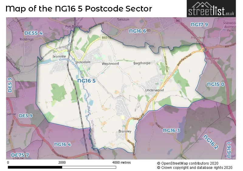
The NG16 5 postcode sector stands on the Derbyshire and Nottinghamshire border.
Did you know? According to the 2021 Census, the NG16 5 postcode sector is home to a bustling 9,825 residents!
Given that each sector allows for 400 unique postcode combinations. Letters C, I, K, M, O and V are not allowed in the last two letters of a postcode. With 205 postcodes already in use, this leaves 195 units available.
The largest settlement in the NG16 5 postal code is Brinsley followed by Underwood, and Jacksdale.
The NG16 5 Postcode shares a border with NG15 0 (Annesley, Newstead Village), NG17 9 (Kirkby-in-Ashfield), DE55 4 (Somercotes, Riddings, Pye Bridge), NG16 3 (Eastwood, Newthorpe), NG16 4 (Langley Mill), NG16 6 (Selston, Pinxton) and DE5 9 (Codnor, Waingroves).
The sector is within the post town of NOTTINGHAM.
NG16 5 is a postcode sector within the NG16 postcode district which is within the NG Nottingham postcode area.
The Royal Mail delivery office for the NG16 5 postal sector is the Eastwood Delivery Office.
The area of the NG16 5 postcode sector is 7.32 square miles which is 18.95 square kilometres or 4,682.67 square acres.
The NG16 5 postcode sector is crossed by the M1 motorway.
Waterways within the NG16 5 postcode sector include the Cromford Canal (disused), Erewash, River Erewash.

Map of the NG16 5 Postcode Sector
Explore the NG16 5 postcode sector by using our free interactive map.
| N | G | 1 | 6 | - | 5 | X | X |
| N | G | 1 | 6 | Space | 5 | Letter | Letter |
Official List of Streets
Ironville (39 Streets)
Jacksdale (29 Streets)
Underwood (30 Streets)
Brinsley (34 Streets)
Westwood (12 Streets)
Bagthorpe (3 Streets)
Unofficial Streets or Alternative Spellings
Newthorpe
WILLEY LANEUnderwood
DESMOND COURT WHEELER GATE ARTHURS VIEW CASTLE DRIVE CINDER BANK FELLEY MILL LANE (NORTH) FELLEY MILL LANE (SOUTH) PINXTON CANAL PATH SELSTON COLLIERY WILLOW COURTAnnesley
MANSFIELD ROADSelston
CRESCENT ROAD LANGTON HOLLOW NOTTINGHAM ROADLangley Mill
ALDERCAR LANEPye Bridge
ALFRETON ROADButterley
COACH ROADSchools and Places of Education Within the NG16 5 Postcode Sector
Bagthorpe Primary School
Community school
School Road, Nottingham, Nottinghamshire, NG16 5HB
Head: Mr David Walton
Ofsted Rating: Good
Inspection: 2019-03-05 (1906 days ago)
Website: Visit Bagthorpe Primary School Website
Phone: 01773782843
Number of Pupils: 168
Brinsley Primary and Nursery School
Community school
Moor Road, Nottingham, Nottinghamshire, NG16 5AZ
Head: Mr Jason Osprey
Ofsted Rating: Good
Inspection: 2023-03-22 (428 days ago)
Website: Visit Brinsley Primary and Nursery School Website
Phone: 01773783898
Number of Pupils: 211
Ironville and Codnor Park Primary School
Academy sponsor led
Victoria Street, Ironville, Derbyshire, NG16 5NB
Head: Mrs Jane Grundy
Ofsted Rating: Good
Inspection: 2022-07-13 (680 days ago)
Website: Visit Ironville and Codnor Park Primary School Website
Phone: 01773602936
Number of Pupils: 119
Jacksdale Primary and Nursery School
Community school
Main Road, Nottingham, Nottinghamshire, NG16 5JU
Head: Miss Julie Brockerton
Ofsted Rating: Good
Inspection: 2018-11-21 (2010 days ago)
Website: Visit Jacksdale Primary and Nursery School Website
Phone: 01773783930
Number of Pupils: 216
Underwood Church of England Primary School
Voluntary controlled school
Main Road, Nottingham, Nottinghamshire, NG16 5GN
Head: Mr Ian Baxter
Ofsted Rating: Good
Inspection: 2023-06-28 (330 days ago)
Website: Visit Underwood Church of England Primary School Website
Phone: 01773782868
Number of Pupils: 176
Westwood Infant and Nursery School
Community school
Palmerston Street, Nottingham, Nottinghamshire, NG16 5JA
Head: Miss Lizzy Woodcock
Ofsted Rating: Good
Inspection: 2023-05-24 (365 days ago)
Website: Visit Westwood Infant and Nursery School Website
Phone: 01773783899
Number of Pupils: 63
House Prices in the NG16 5 Postcode Sector
| Type of Property | 2018 Average | 2018 Sales | 2017 Average | 2017 Sales | 2016 Average | 2016 Sales | 2015 Average | 2015 Sales |
|---|---|---|---|---|---|---|---|---|
| Detached | £239,321 | 43 | £207,856 | 70 | £224,704 | 69 | £211,476 | 75 |
| Semi-Detached | £143,524 | 59 | £129,802 | 60 | £128,654 | 66 | £121,715 | 49 |
| Terraced | £95,986 | 37 | £98,318 | 38 | £88,400 | 32 | £87,842 | 30 |
| Flats | £0 | 0 | £0 | 0 | £0 | 0 | £58,000 | 1 |
Important Postcodes NG16 5 in the Postcode Sector
NG16 5AZ is the postcode for Brinsley Primary School, Moor Road, Brinsley, Brinsley Primary School, Moor Road, and BUILDING 3, Brinsley Primary School, Moor Road
NG16 5HB is the postcode for Bagthorpe Primary School, School Road
NG16 5JA is the postcode for Westwood Infant & Nursery School, Palmerston Street
NG16 5JU is the postcode for Jacksdale Primary & Nursery School, Main Road
NG16 5NB is the postcode for Main Building, Ironville & Codnor Park Primary School, Victoria Street, and Ironville & Codnor Park Primary School, Victoria Street
| The NG16 5 Sector is within these Local Authorities |
|
|---|---|
| The NG16 5 Sector is within these Counties |
|
| The NG16 5 Sector is within these Water Company Areas |
|