The NN17 2 postcode sector is within the county of Northamptonshire.
Did you know? According to the 2021 Census, the NN17 2 postcode sector is home to a bustling 13,092 residents!
Given that each sector allows for 400 unique postcode combinations. Letters C, I, K, M, O and V are not allowed in the last two letters of a postcode. With 257 postcodes already in use, this leaves 143 units available.
The NN17 2 postal code covers the settlement of CORBY.
The NN17 2 Postcode shares a border with NN17 1 (CORBY), NN17 4 (Earlstrees Industrial Estate, CORBY), NN18 0 (CORBY), NN18 9 (CORBY) and LE16 8 (MARKET HARBOROUGH, Cottingham, Great Easton).
The sector is within the post town of CORBY.
NN17 2 is a postcode sector within the NN17 postcode district which is within the NN Northampton postcode area.
The Royal Mail delivery office for the NN17 2 postal sector is the Corby Delivery Office.
The area of the NN17 2 postcode sector is 2.18 square miles which is 5.65 square kilometres or 1,396.75 square acres.

Map of the NN17 2 Postcode Sector
Explore the NN17 2 postcode sector by using our free interactive map.
| N | N | 1 | 7 | - | 2 | X | X |
| N | N | 1 | 7 | Space | 2 | Letter | Letter |
Official List of Streets
CORBY (170 Streets)
Unofficial Streets or Alternative Spellings
Earlstrees Industrial Estate
CAUSEWAY ROAD EARLSTREES ROAD GRETTON BROOK ROADCORBY
DALTON ROAD WATSON CLOSEDeene
GRETTON BROOK ROADCottingham
CORBY ROAD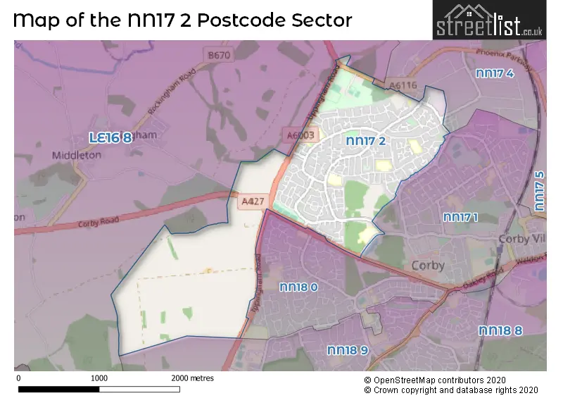
House Prices in the NN17 2 Postcode Sector
| Type of Property | 2018 Average | 2018 Sales | 2017 Average | 2017 Sales | 2016 Average | 2016 Sales | 2015 Average | 2015 Sales |
|---|---|---|---|---|---|---|---|---|
| Detached | £229,778 | 16 | £218,190 | 10 | £196,488 | 9 | £180,421 | 7 |
| Semi-Detached | £162,823 | 87 | £149,720 | 67 | £138,354 | 96 | £122,038 | 104 |
| Terraced | £145,434 | 70 | £132,442 | 58 | £120,362 | 89 | £111,027 | 82 |
| Flats | £103,291 | 17 | £105,417 | 20 | £86,913 | 16 | £78,921 | 19 |
Important Postcodes NN17 2 in the Postcode Sector
NN17 2BP is the postcode for Studfall Infant School, Rowlett Road, and Studfall Infant Academy, Rowlett Road
NN17 2BT is the postcode for Studfall Junior School, Rowlett Road, and Studfall Junior Academy, Rowlett Road
NN17 2EA is the postcode for Ennerdale Community Association, Ennerdale Community Centre, Ennerdale Road
NN17 2JH is the postcode for MAIN BLOCK, Lodge Park School, Shetland Way, BRADY BLOCK, Lodge Park Academy, Shetland Way, MAIN BLOCK, Lodge Park Academy, Shetland Way, WESTON BLOCK, Lodge Park Academy, Shetland Way, Lodge Park Academy, Shetland Way, and RUMBELOW BLOCK, Lodge Park Academy, Shetland Way
NN17 2NU is the postcode for KEY STAGE 2, Woodnewton A Learning Community, Rowlett Road, YEAR 4, Woodnewton A Learning Community, Rowlett Road, YEAR 3, Woodnewton A Learning Community, Rowlett Road, KEY STAGE 1, Woodnewton A Learning Community, Rowlett Road, and MUGGLETON BUILDING, Woodnewton A Learning Community, Rowlett Road
NN17 2SG is the postcode for Lodge Park Sports Centre, Shetland Way
NN17 2UN is the postcode for Nuffield Diagnostic Centre, Cottingham Road, Corby Community Hospital, Cottingham Road, and Dental Access Centre, Cottingham Road
NN17 2UR is the postcode for THE LAKESIDE SURGERY, COTTINGHAM ROAD, CORBY, Willowbrook Health Centre, Cottingham Road, The Lakeside Surgery, Cottingham Road, and Willowbrook Health Centre, The Lakeside Surgery, Cottingham Road
NN17 2UW is the postcode for Nuffield Diagnostic Centre, Cottingham Road
| The NN17 2 Sector is within these Local Authorities |
|
|---|---|
| The NN17 2 Sector is within these Counties |
|
| The NN17 2 Sector is within these Water Company Areas |
|