The NR10 5 postcode sector is within the county of Norfolk.
Did you know? According to the 2021 Census, the NR10 5 postcode sector is home to a bustling 6,843 residents!
Given that each sector allows for 400 unique postcode combinations. Letters C, I, K, M, O and V are not allowed in the last two letters of a postcode. With 219 postcodes already in use, this leaves 181 units available.
The largest settlement in the NR10 5 postal code is Badersfield followed by Hevingham, and Buxton.
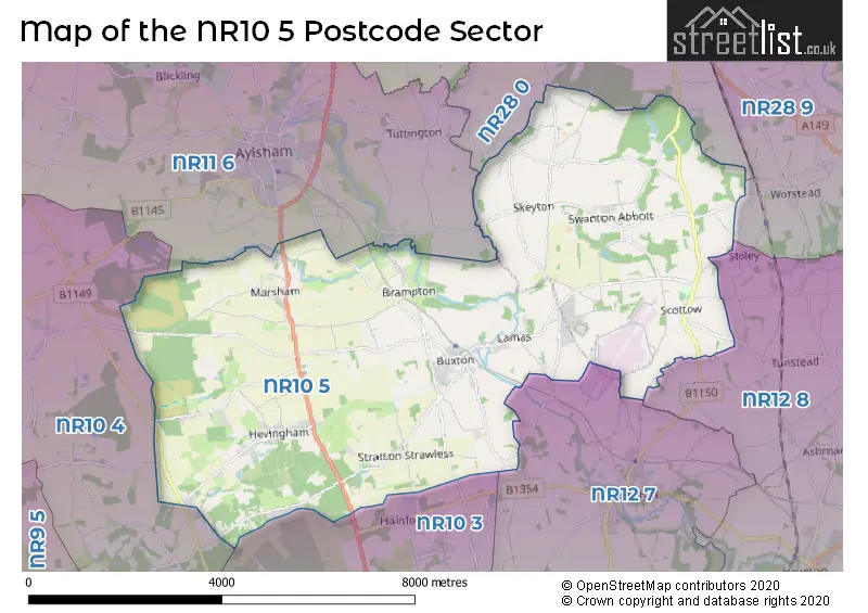
The NR10 5 Postcode shares a border with NR10 3 (Horsford, Spixworth, Horsham St. Faith), NR10 4 (Reepham, Cawston, Felthorpe), NR11 6 (Aylsham, Corpusty, Wood Dalling), NR12 7 (Coltishall, Horstead, Frettenham), NR12 8 (Hoveton, Horning, Wroxham), NR28 0 (NORTH WALSHAM, Trunch, Felmingham) and NR28 9 (NORTH WALSHAM, Worstead, Dilham).
The sector is within the post town of NORWICH.
NR10 5 is a postcode sector within the NR10 postcode district which is within the NR Norwich postcode area.
The Royal Mail delivery office for the NR10 5 postal sector is the North Walsham Delivery Office and Coltishall Scale Payment Delivery Office and Buxton (nr) Scale Payment Delivery Office.
The area of the NR10 5 postcode sector is 25.23 square miles which is 65.35 square kilometres or 16,147.47 square acres.
Waterways within the NR10 5 postcode sector include the River Bure.

Map of the NR10 5 Postcode Sector
Explore the NR10 5 postcode sector by using our free interactive map.
| N | R | 1 | 0 | - | 5 | X | X |
| N | R | 1 | 0 | Space | 5 | Letter | Letter |
Official List of Streets
Marsham (17 Streets)
Buxton (30 Streets)
Swanton Abbott (10 Streets)
Badersfield (11 Streets)
Hevingham (25 Streets)
Skeyton (13 Streets)
Stratton Strawless (13 Streets)
Brampton (4 Streets)
Scottow (9 Streets)
Westwick (6 Streets)
Unofficial Streets or Alternative Spellings
Sloley
LOW STREETColtishall
NORTH WALSHAM ROADHorstead
BUXTON ROAD MAYTON ROADFrettenham
BUXTON ROADNORTH WALSHAM
SKEYTON ROADFelmingham
CHURCH ROADHainford
CROMER ROAD STRATTON ROADMarsham
LITTLE LONDON LANEAylsham
BUXTON ROAD NORWICH ROADCawston
BUXTON ROAD HOLT ROADSchools and Places of Education Within the NR10 5 Postcode Sector
Buxton Primary School
Foundation school
Aylsham Road, Norwich, Norfolk, NR10 5EZ
Head: Mrs Juliet Stops
Ofsted Rating: Outstanding
Inspection: 2017-11-01 (2395 days ago)
Website: Visit Buxton Primary School Website
Phone: 01603279357
Number of Pupils: 203
Hevingham Primary School
Foundation school
New Road, Norwich, Norfolk, NR10 5NH
Head: Mrs Lydia Board
Ofsted Rating: Good
Inspection: 2018-03-08 (2268 days ago)
Website: Visit Hevingham Primary School Website
Phone: 01603754677
Number of Pupils: 94
Marsham Primary School
Foundation school
High Street, Norwich, Norfolk, NR10 5AE
Head: Mrs Lydia Board
Ofsted Rating: Good
Inspection: 2019-01-08 (1962 days ago)
Website: Visit Marsham Primary School Website
Phone: 01263732364
Number of Pupils: 21
Swanton Abbott Community Primary School
Community school
Youngman's Lane, Norwich, Norfolk, NR10 5DZ
Head: Mr David Hopkins
Ofsted Rating: Good
Inspection: 2023-05-05 (384 days ago)
Website: Visit Swanton Abbott Community Primary School Website
Phone: 01692538246
Number of Pupils: 78
UET Pathfinder Academy
Academy alternative provision converter
Douglas Bader School, Norwich, Norfolk, NR10 5JW
Head: Mr Stephen Plume
Ofsted Rating: Good
Inspection: 2019-06-05 (1814 days ago)
Website: Visit UET Pathfinder Academy Website
Phone: 01603737764
Number of Pupils: 315
House Prices in the NR10 5 Postcode Sector
| Type of Property | 2018 Average | 2018 Sales | 2017 Average | 2017 Sales | 2016 Average | 2016 Sales | 2015 Average | 2015 Sales |
|---|---|---|---|---|---|---|---|---|
| Detached | £368,519 | 33 | £338,863 | 26 | £325,038 | 38 | £300,663 | 44 |
| Semi-Detached | £211,803 | 20 | £189,439 | 17 | £194,600 | 20 | £166,028 | 17 |
| Terraced | £165,422 | 32 | £160,987 | 35 | £152,642 | 33 | £147,089 | 36 |
| Flats | £88,125 | 4 | £133,750 | 6 | £135,400 | 5 | £96,278 | 9 |
Important Postcodes NR10 5 in the Postcode Sector
NR10 5DZ is the postcode for Swanton Abbott Community Primary School, Youngmans Lane
NR10 5EZ is the postcode for Buxton Primary School, Aylsham Road, and Buxton Primary School, Aylsham Road, Buxton
NR10 5GB is the postcode for VISITS & ADMIN BUILDING, H M Prison Bure, Jaguar Drive, and H M Prison Bure, Jaguar Drive
NR10 5JW is the postcode for The Douglas Bader School, Filby Road, and The Douglas Bader School, Filby Road, Badersfield
NR10 5NH is the postcode for Hevingham Cp School, Westgate
| The NR10 5 Sector is within these Local Authorities |
|
|---|---|
| The NR10 5 Sector is within these Counties |
|
| The NR10 5 Sector is within these Water Company Areas |
|