The OL10 2 postcode sector is within the county of Greater Manchester.
Did you know? According to the 2021 Census, the OL10 2 postcode sector is home to a bustling 6,986 residents!
Given that each sector allows for 400 unique postcode combinations. Letters C, I, K, M, O and V are not allowed in the last two letters of a postcode. With 197 postcodes already in use, this leaves 203 units available.
The largest settlements in the OL10 2 postal code are HEYWOOD and Heywood Distribution Park.
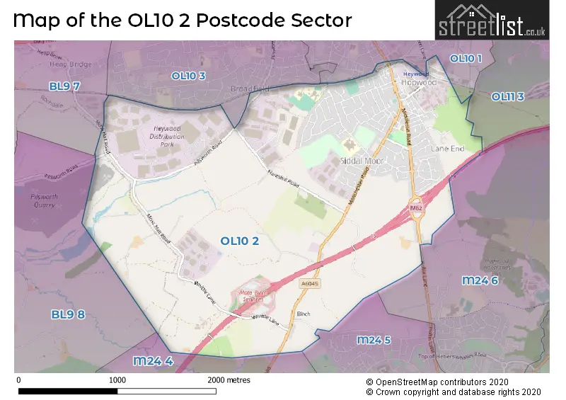
The OL10 2 Postcode shares a border with OL10 1 (HEYWOOD), OL10 3 (HEYWOOD), OL11 3 (ROCHDALE), M24 5 (Middleton), BL9 7 (BURY, Heap Bridge, Heap), BL9 8 (BURY, Unsworth), M24 4 (Middleton) and M24 6 (Middleton).
The sector is within the post town of HEYWOOD.
OL10 2 is a postcode sector within the OL10 postcode district which is within the OL Oldham postcode area.
The Royal Mail delivery office for the OL10 2 postal sector is the Heywood Delivery Office.
The area of the OL10 2 postcode sector is 3.25 square miles which is 8.43 square kilometres or 2,083.00 square acres.
The OL10 2 postcode sector is crossed by the M62 motorway.

Map of the OL10 2 Postcode Sector
Explore the OL10 2 postcode sector by using our free interactive map.
| O | L | 1 | 0 | - | 2 | X | X |
| O | L | 1 | 0 | Space | 2 | Letter | Letter |
Official List of Streets
HEYWOOD (124 Streets)
Unofficial Streets or Alternative Spellings
HEYWOOD
KING STREET MANCHESTER STREET PARK STREET RAILWAY STREET BACK MANCHESTER STREET HEYWOOD INTERCHANGE HOPE STREET LYNHAM DRIVE MERCER ROAD MERRICK STREET OLDRURY CLOSE QUEEN ELIZABETH WAY SERVICES BIRCH WHITE HOUSE CLOSEMiddleton
HEYWOOD OLD ROAD HOLLIN LANE LANGLEY LANEBURY,
MOSS HALL ROADBURY
PILSWORTH ROADSchools and Places of Education Within the OL10 2 Postcode Sector
Edgar Wood Academy
Free schools
Heywood Old Road, Heywood, , OL10 2QN
Head: Mr Paul Jones
Ofsted Rating: Requires improvement
Inspection: 2023-11-22 (183 days ago)
Website: Visit Edgar Wood Academy Website
Phone: 01616769620
Number of Pupils: 295
Holy Family Roman Catholic and Church of England College
Voluntary aided school
Pot Hall, Heywood, Lancashire, OL10 2AA
Head: Mrs Karen Ames
Ofsted Rating: Good
Inspection: 2022-01-26 (848 days ago)
Website: Visit Holy Family Roman Catholic and Church of England College Website
Phone: 01706360607
Number of Pupils: 750
Hopwood Community Primary School
Community school
Magdala Street, Heywood, Lancashire, OL10 2HN
Head: Mrs Gill Sarginson
Ofsted Rating: Outstanding
Inspection: 2008-10-09 (5705 days ago)
Website: Visit Hopwood Community Primary School Website
Phone: 01706360494
Number of Pupils: 421
Newhouse Academy
Academy sponsor led
Newhouse Road, Heywood, Lancashire, OL10 2NT
Head: Mr Alex Burnham
Ofsted Rating: Requires improvement
Inspection: 2023-11-16 (189 days ago)
Website: Visit Newhouse Academy Website
Phone: 01706369436
Number of Pupils: 998
St Joseph's Roman Catholic Primary School, Rochdale
Voluntary aided school
Pot Hall, Heywood, Lancashire, OL10 2AA
Head: Mrs Caroline Dunne
Ofsted Rating: Good
Inspection: 2020-02-19 (1555 days ago)
Website: Visit St Joseph's Roman Catholic Primary School, Rochdale Website
Phone: 01706369340
Number of Pupils: 403
House Prices in the OL10 2 Postcode Sector
| Type of Property | 2018 Average | 2018 Sales | 2017 Average | 2017 Sales | 2016 Average | 2016 Sales | 2015 Average | 2015 Sales |
|---|---|---|---|---|---|---|---|---|
| Detached | £268,089 | 22 | £249,570 | 33 | £254,564 | 39 | £211,976 | 53 |
| Semi-Detached | £164,444 | 26 | £155,019 | 45 | £160,215 | 23 | £160,192 | 31 |
| Terraced | £103,854 | 37 | £94,721 | 29 | £99,614 | 38 | £96,579 | 38 |
| Flats | £84,679 | 28 | £71,993 | 7 | £65,331 | 120 | £77,929 | 7 |
Important Postcodes OL10 2 in the Postcode Sector
OL10 2AA is the postcode for St. Josephs RC High School, Pothill, History & Geography Block, Holy Family RC & CE College, Pot Hill, Holy Family RC & CE College, Pothill, St. Josephs RC Primary School, Pothill, Sports Hall, Holy Family RC & CE College, Pot Hill, St. Josephs RC Primary School, Pothill, Wilton Grove, and Main Building, Holy Family RC & CE College, Pot Hill
OL10 2DY is the postcode for Pennine Care NHS Foundation Trust, Callaghan House, Rochdale M B C Environmental Management, Green Lane, and RMBC Environmental Management, Green Lane Depot
OL10 2HN is the postcode for Hopwood Cp School, Magdala Street
OL10 2LU is the postcode for Greater Manchester Fire & Rescue Service, Fire Station, 129 Middleton Road, and MAIN BUILDING, Greater Manchester Fire & Rescue Service, Fire Station, 129 Middleton Road
OL10 2NT is the postcode for Siddal Moor Sports College, Newhouse Road, and NEWHOUSE ACADEMY, NEWHOUSE ROAD
OL10 2PZ is the postcode for BUILDING 117, Heywood Stores, 112 Manchester Road, BUILDING 118, Heywood Stores, 112 Manchester Road, BUILDING 115, Heywood Stores, 112 Manchester Road, BUILDING 113, Heywood Stores, 112 Manchester Road, BUILDINGS 111-119, Heywood Stores, 112 Manchester Road, BUILDING 114, Heywood Stores, 112 Manchester Road, BUILDING 116, Heywood Stores, 112 Manchester Road, BUILDING 110, Heywood Stores, 112 Manchester Road, and BUILDING 112, Heywood Stores, 112 Manchester Road
| The OL10 2 Sector is within these Local Authorities |
|
|---|---|
| The OL10 2 Sector is within these Counties |
|
| The OL10 2 Sector is within these Water Company Areas |
|
Tourist Attractions within the OL10 2 Postcode Area
We found 1 visitor attractions within the OL10 postcode area
| East Lancashire Railway |
|---|
| Railways |
| Steam / Heritage Railway |
| View East Lancashire Railway on Google Maps |