The OL13 8 postcode sector stands on the Lancashire and West Yorkshire border.
Did you know? According to the 2021 Census, the OL13 8 postcode sector is home to a bustling 4,642 residents!
Given that each sector allows for 400 unique postcode combinations. Letters C, I, K, M, O and V are not allowed in the last two letters of a postcode. With 206 postcodes already in use, this leaves 194 units available.
The OL13 8 postal code covers the settlement of BACUP.
The OL13 8 Postcode shares a border with OL13 9 (BACUP, Britannia), OL14 8 (TODMORDEN), BB4 9 (ROSSENDALE, Waterfoot, Newchurch), BB10 4 (BURNLEY, Cliviger), OL13 0 (BACUP, Stacksteads), OL14 7 (TODMORDEN) and BB11 3 (BURNLEY, Cliviger).
The sector is within the post town of BACUP.
OL13 8 is a postcode sector within the OL13 postcode district which is within the OL Oldham postcode area.
The Royal Mail delivery office for the OL13 8 postal sector is the Bacup Delivery Office.
The area of the OL13 8 postcode sector is 6.43 square miles which is 16.66 square kilometres or 4,117.34 square acres.

Map of the OL13 8 Postcode Sector
Explore the OL13 8 postcode sector by using our free interactive map.
| O | L | 1 | 3 | - | 8 | X | X |
| O | L | 1 | 3 | Space | 8 | Letter | Letter |
Official List of Streets
BACUP (114 Streets)
Stacksteads (2 Streets)
Unofficial Streets or Alternative Spellings
BACUP
FIELD TOP IRWELL STREET LODGE LANE MITCHELL FIELD NOOK NEWCHURCH ROAD SPRING MOUNT TOWER STREET UNION STREET WESLEY TERRACE BACK HOPE STREET BACK ST JOHN STREET CHURCH GARDENS ELGIN STREET GOOSE HILL STREET HALL STREET HARCOURT STREET MILL STREAM CLOSE MONKS HOUSE RIDE OFFICE ROAD ROSSENDALE WAY SOW CLOUGH ROAD THISTLE STREETROSSENDALE
CARR ROAD DEAN LANE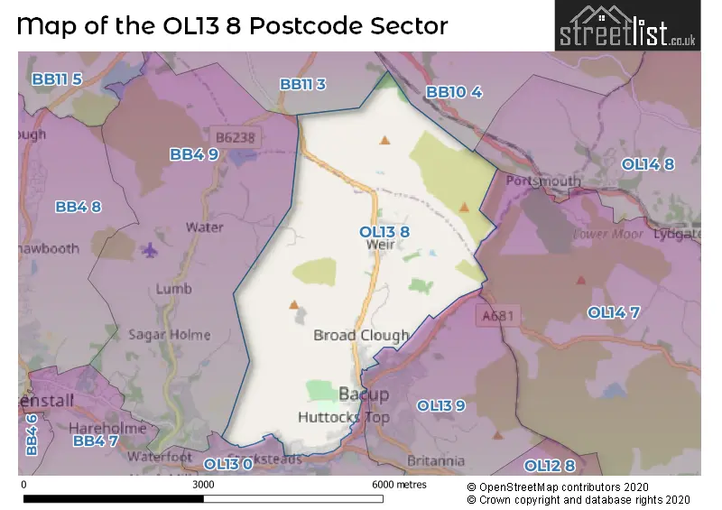
House Prices in the OL13 8 Postcode Sector
| Type of Property | 2018 Average | 2018 Sales | 2017 Average | 2017 Sales | 2016 Average | 2016 Sales | 2015 Average | 2015 Sales |
|---|---|---|---|---|---|---|---|---|
| Detached | £258,536 | 28 | £208,657 | 22 | £262,020 | 23 | £207,979 | 29 |
| Semi-Detached | £152,286 | 28 | £114,161 | 19 | £122,778 | 18 | £139,456 | 17 |
| Terraced | £77,980 | 40 | £72,724 | 29 | £71,864 | 40 | £57,272 | 37 |
| Flats | £0 | 0 | £53,000 | 2 | £0 | 0 | £31,000 | 1 |
Important Postcodes OL13 8 in the Postcode Sector
OL13 8AA is the postcode for Royal Mail, Bacup Delivery Office, 5 Burnley Road
OL13 8EF is the postcode for Bacup Thorn Primary School, Cowtoot Lane
OL13 8LR is the postcode for St. Joseph School, Huttock End Lane
OL13 8PH is the postcode for Northern Primary School, Plantation View
| The OL13 8 Sector is within these Local Authorities |
|
|---|---|
| The OL13 8 Sector is within these Counties |
|
| The OL13 8 Sector is within these Water Company Areas |
|