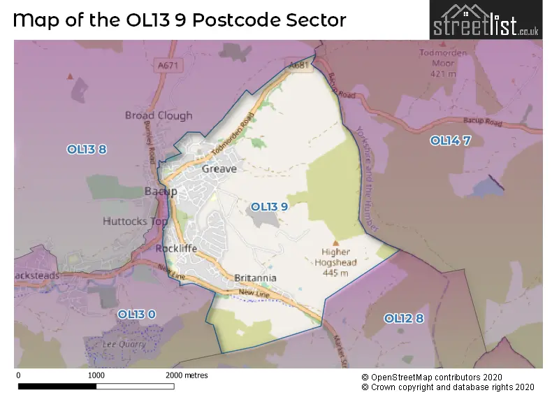
The OL13 9 postcode sector stands on the Lancashire and West Yorkshire border.
Did you know? According to the 2021 Census, the OL13 9 postcode sector is home to a bustling 8,165 residents!
Given that each sector allows for 400 unique postcode combinations. Letters C, I, K, M, O and V are not allowed in the last two letters of a postcode. With 242 postcodes already in use, this leaves 158 units available.
The largest settlements in the OL13 9 postal code are BACUP and Britannia.
The OL13 9 Postcode shares a border with OL13 8 (BACUP), OL12 8 (Whitworth, Shawforth, Facit), OL13 0 (BACUP, Stacksteads) and OL14 7 (TODMORDEN).
The sector is within the post town of BACUP.
OL13 9 is a postcode sector within the OL13 postcode district which is within the OL Oldham postcode area.
The Royal Mail delivery office for the OL13 9 postal sector is the Bacup Delivery Office.
The area of the OL13 9 postcode sector is 2.72 square miles which is 7.04 square kilometres or 1,740.44 square acres.

Map of the OL13 9 Postcode Sector
Explore the OL13 9 postcode sector by using our free interactive map.
| O | L | 1 | 3 | - | 9 | X | X |
| O | L | 1 | 3 | Space | 9 | Letter | Letter |
Official List of Streets
BACUP (153 Streets)
Britannia (3 Streets)
Unofficial Streets or Alternative Spellings
BACUP
BLACKTHORN LANE BURNLEY ROAD CO-OPERATION STREET CROOKED SHORE HEIGHT BARN LANE HENRIETTA STREET LEE STREET RAILGATE ROCKCLIFFE ROAD TODMORDEN OLD ROAD UNION STREETShawforth
OLD LANE ALLAN STREET BATH STREET BENTLEY STREET BOOTH STREET BOSTON ROAD COTTON MILL COURT CROSS STREET GRAFTON VILLAS GREENS LANE HALL STREET HARCOURT STREET HARRISON STREET HIGHER CROSS ROW INDUSTRIAL PLACE KENYON STREET KERSHAW STREET LANE END LANE LUMB SCAR METTLE COTE NEW LINE CONNECTION QUARRY STREET REED STREET SARAH STREET SPRING GARDENS STACK LANE THE COURTYARD VALLEY CLOSESchools and Places of Education Within the OL13 9 Postcode Sector
Bacup St Saviour's Community Primary School
Community school
Lane End Road, Bacup, Lancashire, OL13 9RR
Head: Ms Deanne Marsh
Ofsted Rating: Good
Inspection: 2019-03-07 (1914 days ago)
Website: Visit Bacup St Saviour's Community Primary School Website
Phone: 01706877900
Number of Pupils: 100
Britannia Community Primary School
Community school
Rochdale Road, Bacup, Lancashire, OL13 9TS
Head: Mrs N Longstaff
Ofsted Rating: Good
Inspection: 2022-01-26 (858 days ago)
Website: Visit Britannia Community Primary School Website
Phone: 01706874447
Number of Pupils: 209
Sharneyford Primary School
Community school
Todmorden Road, Bacup, Lancashire, OL13 9UQ
Head: Mrs Andrea Holt
Ofsted Rating: Good
Inspection: 2022-06-09 (724 days ago)
Website: Visit Sharneyford Primary School Website
Phone: 01706873955
Number of Pupils: 62
House Prices in the OL13 9 Postcode Sector
| Type of Property | 2018 Average | 2018 Sales | 2017 Average | 2017 Sales | 2016 Average | 2016 Sales | 2015 Average | 2015 Sales |
|---|---|---|---|---|---|---|---|---|
| Detached | £196,554 | 46 | £195,826 | 80 | £173,178 | 58 | £160,418 | 40 |
| Semi-Detached | £127,048 | 38 | £113,105 | 30 | £116,125 | 34 | £104,468 | 20 |
| Terraced | £83,175 | 52 | £78,585 | 62 | £72,873 | 54 | £63,695 | 41 |
| Flats | £0 | 0 | £0 | 0 | £64,000 | 2 | £43,495 | 11 |
Important Postcodes OL13 9 in the Postcode Sector
OL13 9AH is the postcode for Rossendale Borough Council, Bacup Library, St. James Square
OL13 9LJ is the postcode for St. Marys RC Primary School, Tong Lane
OL13 9NR is the postcode for Bacup Primary Health Centre, Rochdale Road, and Bacup Primary Health Trust, Irwell Medical Centre Irwell Mill, Rochdale Road
OL13 9NZ is the postcode for Bacup Sure Start, The Maden Centre, Rochdale Road
OL13 9RR is the postcode for St. Saviours Cp School, Lane End Road
OL13 9TS is the postcode for Britannia County Primary School, Rochdale Road, and Britannia Cp School, Rochdale Road
OL13 9UQ is the postcode for Sharneyford Primary School, Todmorden Road
| The OL13 9 Sector is within these Local Authorities |
|
|---|---|
| The OL13 9 Sector is within these Counties |
|
| The OL13 9 Sector is within these Water Company Areas |
|