The OL16 4 postcode sector is within the county of Greater Manchester.
Did you know? According to the 2021 Census, the OL16 4 postcode sector is home to a bustling 12,567 residents!
Given that each sector allows for 400 unique postcode combinations. Letters C, I, K, M, O and V are not allowed in the last two letters of a postcode. With 287 postcodes already in use, this leaves 113 units available.
The largest settlement in the OL16 4 postal code is ROCHDALE followed by Milnrow, and Newhey.
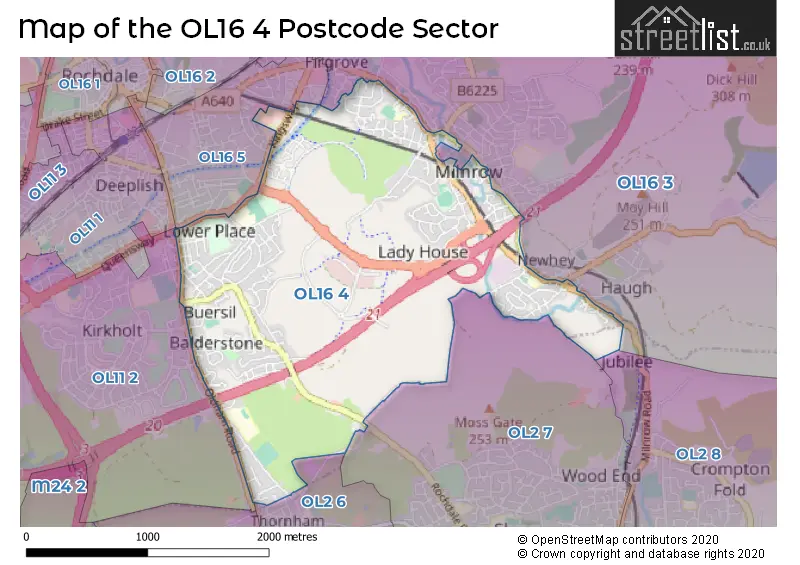
The OL16 4 Postcode shares a border with OL16 5 (ROCHDALE), OL2 7 (Shaw), OL2 8 (Shaw), OL11 2 (ROCHDALE), OL2 6 (Royton) and OL16 3 (Milnrow, Newhey, ROCHDALE).
The sector is within the post town of ROCHDALE.
OL16 4 is a postcode sector within the OL16 postcode district which is within the OL Oldham postcode area.
The Royal Mail delivery office for the OL16 4 postal sector is the Rochdale Delivery Office.
The area of the OL16 4 postcode sector is 2.40 square miles which is 6.22 square kilometres or 1,537.58 square acres.
The OL16 4 postcode sector is crossed by the M62 motorway.
Waterways within the OL16 4 postcode sector include the Rochdale Canal.

Map of the OL16 4 Postcode Sector
Explore the OL16 4 postcode sector by using our free interactive map.
| O | L | 1 | 6 | - | 4 | X | X |
| O | L | 1 | 6 | Space | 4 | Letter | Letter |
Official List of Streets
ROCHDALE (105 Streets)
Newhey (24 Streets)
Milnrow (69 Streets)
Burnedge (4 Streets)
Unofficial Streets or Alternative Spellings
Newhey
BROOM STREET GORDON STREET HUDDERSFIELD ROAD LEYWOOD DRIVE STEWART STREET TWO BRIDGES ROAD ASHGROVE BERESFORD STREET BROADVIEW COURT BROOK LANE BUERSIL STREET CALF HEY NORTH ELLENROAD APPROACH ELLENROAD STREET GILLBROOK WAY GRANVILLE COURT HARROW STREET HUGHTREDE STREET KINGS ROAD METROLINK MILNROW INTERCHANGE MOOR BANK LANE NAILGATE NEW BARN STREET NORBURY STREET PLUMPTON ROAD RYELAND CLOSE SAINT JOSEPHS DRIVE SAINT MARYS CLOSE SIR ISAAC NEWTON WAY STANNEY BROOK CYCLEWAY WAREINGS YARD WHEATHILL STREETMilnrow
ALBERT STREET BRIDGE STREET CHAPEL GATE CHARLES LANE CORNFIELD STREET HARBOUR LANE NORTH HARMONY STREET HEATON STREET KILN LANE ROYDS STREET SHERIFF STREET SHORE STREET WESTON STREET WHITEHEAD STREETROCHDALE
BURLINGTON STREET COUNT STREET HARVARD STREET MELBOURNE ROAD QUEENSWAY THORNHAM NEW ROADFirgrove
HALLIWELL STREET ROCHDALE ROADRoyton
PIT LANEWeather Forecast for OL16 4
Press Button to Show Forecast for Milnrow
| Time Period | Icon | Description | Temperature | Rain Probability | Wind |
|---|---|---|---|---|---|
| 03:00 to 06:00 | Heavy rain | 7.0°C (feels like 3.0°C) | 82.00% | SSW 13 mph | |
| 06:00 to 09:00 | Cloudy | 7.0°C (feels like 4.0°C) | 45.00% | S 13 mph | |
| 09:00 to 12:00 | Cloudy | 10.0°C (feels like 7.0°C) | 10.00% | S 16 mph | |
| 12:00 to 15:00 | Overcast | 11.0°C (feels like 8.0°C) | 15.00% | S 18 mph | |
| 15:00 to 18:00 | Light rain | 12.0°C (feels like 8.0°C) | 58.00% | S 18 mph | |
| 18:00 to 21:00 | Heavy rain | 11.0°C (feels like 7.0°C) | 78.00% | S 18 mph | |
| 21:00 to 00:00 | Light rain | 10.0°C (feels like 7.0°C) | 47.00% | S 16 mph |
Press Button to Show Forecast for Milnrow
| Time Period | Icon | Description | Temperature | Rain Probability | Wind |
|---|---|---|---|---|---|
| 00:00 to 03:00 | Cloudy | 10.0°C (feels like 7.0°C) | 46.00% | S 13 mph | |
| 03:00 to 06:00 | Cloudy | 9.0°C (feels like 6.0°C) | 5.00% | SSE 11 mph | |
| 06:00 to 09:00 | Partly cloudy (day) | 9.0°C (feels like 6.0°C) | 2.00% | SE 11 mph | |
| 09:00 to 12:00 | Cloudy | 12.0°C (feels like 9.0°C) | 3.00% | SSE 16 mph | |
| 12:00 to 15:00 | Partly cloudy (day) | 16.0°C (feels like 12.0°C) | 2.00% | SSE 16 mph | |
| 15:00 to 18:00 | Cloudy | 16.0°C (feels like 13.0°C) | 8.00% | SSE 16 mph | |
| 18:00 to 21:00 | Cloudy | 14.0°C (feels like 13.0°C) | 9.00% | S 9 mph | |
| 21:00 to 00:00 | Cloudy | 11.0°C (feels like 10.0°C) | 10.00% | ESE 4 mph |
Press Button to Show Forecast for Milnrow
| Time Period | Icon | Description | Temperature | Rain Probability | Wind |
|---|---|---|---|---|---|
| 00:00 to 03:00 | Overcast | 10.0°C (feels like 9.0°C) | 16.00% | SE 4 mph | |
| 03:00 to 06:00 | Cloudy | 9.0°C (feels like 9.0°C) | 9.00% | SE 4 mph | |
| 06:00 to 09:00 | Cloudy | 9.0°C (feels like 9.0°C) | 9.00% | SE 4 mph | |
| 09:00 to 12:00 | Partly cloudy (day) | 12.0°C (feels like 11.0°C) | 6.00% | SE 4 mph | |
| 12:00 to 15:00 | Cloudy | 15.0°C (feels like 14.0°C) | 10.00% | SSE 4 mph | |
| 15:00 to 18:00 | Cloudy | 15.0°C (feels like 15.0°C) | 10.00% | ESE 4 mph | |
| 18:00 to 21:00 | Cloudy | 14.0°C (feels like 14.0°C) | 10.00% | NNE 7 mph | |
| 21:00 to 00:00 | Cloudy | 12.0°C (feels like 11.0°C) | 8.00% | NE 7 mph |
Press Button to Show Forecast for Milnrow
| Time Period | Icon | Description | Temperature | Rain Probability | Wind |
|---|---|---|---|---|---|
| 00:00 to 03:00 | Cloudy | 11.0°C (feels like 10.0°C) | 13.00% | NNE 7 mph | |
| 03:00 to 06:00 | Cloudy | 10.0°C (feels like 9.0°C) | 11.00% | N 7 mph | |
| 06:00 to 09:00 | Light rain | 10.0°C (feels like 9.0°C) | 39.00% | N 7 mph | |
| 09:00 to 12:00 | Cloudy | 12.0°C (feels like 11.0°C) | 10.00% | NNW 9 mph | |
| 12:00 to 15:00 | Cloudy | 15.0°C (feels like 13.0°C) | 5.00% | NNW 11 mph | |
| 15:00 to 18:00 | Cloudy | 17.0°C (feels like 14.0°C) | 5.00% | NNW 11 mph | |
| 18:00 to 21:00 | Sunny day | 15.0°C (feels like 13.0°C) | 3.00% | NNW 11 mph | |
| 21:00 to 00:00 | Cloudy | 12.0°C (feels like 10.0°C) | 6.00% | NNW 9 mph |
Schools and Places of Education Within the OL16 4 Postcode Sector
Lowerplace Primary School
Community school
Kingsway, Rochdale, Lancashire, OL16 4UU
Head: Ms Karen Martin
Ofsted Rating: Good
Inspection: 2019-05-09 (1817 days ago)
Website: Visit Lowerplace Primary School Website
Phone: 01706648174
Number of Pupils: 513
Moorhouse Academy
Academy sponsor led
Crossley Street, Rochdale, Lancashire, OL16 4DR
Head: Mrs Kelly Milnes
Ofsted Rating: Good
Inspection: 2023-10-18 (194 days ago)
Website: Visit Moorhouse Academy Website
Phone: 01706642742
Number of Pupils: 240
Newhey Community Primary School
Community school
Hawthorn Lane, Rochdale, Lancashire, OL16 4JX
Head: Mrs L Sykes
Ofsted Rating: Good
Inspection: 2021-12-02 (879 days ago)
Website: Visit Newhey Community Primary School Website
Phone: 01706847658
Number of Pupils: 312
Sacred Heart Roman Catholic Primary School Rochdale
Voluntary aided school
Kingsway, Rochdale, Lancashire, OL16 4AW
Head: Mrs Pamela Dungworth
Ofsted Rating: Good
Inspection: 2019-06-13 (1782 days ago)
Website: Visit Sacred Heart Roman Catholic Primary School Rochdale Website
Phone: 01706649981
Number of Pupils: 230
House Prices in the OL16 4 Postcode Sector
| Type of Property | 2018 Average | 2018 Sales | 2017 Average | 2017 Sales | 2016 Average | 2016 Sales | 2015 Average | 2015 Sales |
|---|---|---|---|---|---|---|---|---|
| Detached | £260,784 | 49 | £260,202 | 65 | £239,366 | 78 | £226,638 | 78 |
| Semi-Detached | £151,572 | 92 | £149,930 | 89 | £136,602 | 89 | £148,260 | 85 |
| Terraced | £126,439 | 92 | £124,599 | 86 | £107,340 | 73 | £109,402 | 67 |
| Flats | £104,064 | 7 | £100,340 | 10 | £86,500 | 1 | £120,000 | 3 |
Important Postcodes OL16 4 in the Postcode Sector
OL16 4AW is the postcode for Sacred Heart RC Primary School, Kingsway
OL16 4DR is the postcode for Moorhouse Primary Infants School, Crossley Street, Moorhouse Academy, Crossley Street, Milnrow, Moorhouse Academy EYC, Crossley Street, Milnrow, and Moorhouse Cp School, Crossley Street
OL16 4EG is the postcode for Milnrow Village Practice, 44-48 Newhey Road
OL16 4HZ is the postcode for Milnrow Health Centre, Stonefield Street
OL16 4JQ is the postcode for Stonefield Street Surgery, 21 Stonefield Street
OL16 4JX is the postcode for Newhey Community Primary School, Hawthorne Lane
OL16 4PP is the postcode for Springhill Resource Centre, Broad Lane
OL16 4PZ is the postcode for Springhill Hospice, Broad Lane
OL16 4RX is the postcode for St. Cuthberts RC High School, Shaw Road, CARITAS BUILDING, St. Cuthberts RC High School, Shaw Road, and MAIN BUILDING, St. Cuthberts RC High School, Shaw Road
OL16 4UU is the postcode for Lower Place Infants School, Kingsway, and Lower Place School, Kingsway
OL16 4XA is the postcode for Kingsway Park High School, Turf Hill Road
| The OL16 4 Sector is within these Local Authorities |
|
|---|---|
| The OL16 4 Sector is within these Counties |
|
| The OL16 4 Sector is within these Water Company Areas |
|