The OX29 0 postcode sector is within the county of Oxfordshire.
Did you know? According to the 2021 Census, the OX29 0 postcode sector is home to a bustling 1,803 residents!
Given that each sector allows for 400 unique postcode combinations. Letters C, I, K, M, O and V are not allowed in the last two letters of a postcode. With 68 postcodes already in use, this leaves 332 units available.
The largest settlement in the OX29 0 postal code is Minster Lovell followed by Curbridge, and WITNEY.
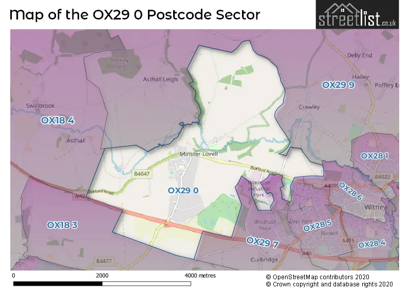
The OX29 0 Postcode shares a border with OX28 5 (WITNEY, Richmond Village), OX18 3 (CARTERTON, Brize Norton), OX18 4 (BURFORD, Fulbrook, Shilton), OX28 6 (WITNEY), OX29 7 (WITNEY, Ducklington, Standlake) and OX29 9 (Hailey, Leafield, Crawley).
The sector is within the post town of WITNEY.
OX29 0 is a postcode sector within the OX29 postcode district which is within the OX Oxford postcode area.
The Royal Mail delivery office for the OX29 0 postal sector is the Witney Delivery Office.
The area of the OX29 0 postcode sector is 4.83 square miles which is 12.51 square kilometres or 3,090.78 square acres.
Waterways within the OX29 0 postcode sector include the River Windrush, Windrush, Doctors Ditch?.

Map of the OX29 0 Postcode Sector
Explore the OX29 0 postcode sector by using our free interactive map.
| O | X | 2 | 9 | - | 0 | X | X |
| O | X | 2 | 9 | Space | 0 | Letter | Letter |
Official List of Streets
Minster Lovell (29 Streets)
WITNEY (7 Streets)
Unofficial Streets or Alternative Spellings
Crawley
DRY LANEWITNEY
OLLEY CRESCENT WINDRUSH PARK ROADSchools and Places of Education Within the OX29 0 Postcode Sector
St Kenelm's Church of England (VC) School
Voluntary controlled school
Wenrisc Drive, Witney, Oxfordshire, OX29 0SP
Head: Mrs Catherine Souch
Ofsted Rating: Good
Inspection: 2023-11-01 (204 days ago)
Website: Visit St Kenelm's Church of England (VC) School Website
Phone: 01993775394
Number of Pupils: 141
House Prices in the OX29 0 Postcode Sector
| Type of Property | 2018 Average | 2018 Sales | 2017 Average | 2017 Sales | 2016 Average | 2016 Sales | 2015 Average | 2015 Sales |
|---|---|---|---|---|---|---|---|---|
| Detached | £633,333 | 6 | £418,571 | 7 | £477,412 | 17 | £475,583 | 6 |
| Semi-Detached | £280,500 | 4 | £346,667 | 6 | £472,500 | 2 | £260,065 | 3 |
| Terraced | £254,000 | 6 | £213,000 | 1 | £225,667 | 3 | £331,500 | 2 |
| Flats | £0 | 0 | £559,395 | 1 | £0 | 0 | £410,000 | 1 |
Important Postcodes OX29 0 in the Postcode Sector
OX29 0SP is the postcode for St. Kenelms C of E School, Wenrisc Drive
| The OX29 0 Sector is within these Local Authorities |
|
|---|---|
| The OX29 0 Sector is within these Counties |
|
| The OX29 0 Sector is within these Water Company Areas |
|