
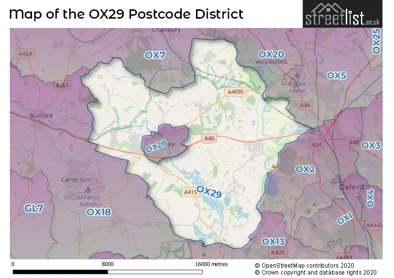
Map of the Postcode District
Explore the postcode district by using our interactive map.
Circles represent recorded crime; the larger the circle, the higher the crime rates.
Your support helps keep this site running!
If you enjoy using this website, consider buying me a coffee to help cover hosting costs.
The postcode district located in the OX Oxford postal area , OX29 has a population of 26,942 residents according to the 2021 England and Wales Census.
The area of the district is 70.65 square miles (182.98 square kilometers or 45,216.17 acres).
Where is the OX29 District?
To give you an idea where the district is located we have created the following table showing nearby towns.
Nearest Towns to OX29
| Town | Distance (miles) | Direction |
|---|---|---|
| Witney | 1.70 | W |
| Woodstock | 5.67 | NE |
| Charlbury | 6.05 | NNW |
| Carterton | 6.70 | WSW |
| Kidlington | 7.11 | ENE |
| Burford | 8.31 | W |
| Oxford | 8.43 | ESE |
| Faringdon | 10.78 | SSW |
| Abingdon-on-Thames | 10.79 | SE |
| Chipping Norton | 11.42 | NNW |
| Lechlade-on-Thames | 12.44 | WSW |
| Wantage | 13.85 | S |
| Bicester | 14.63 | ENE |
| Didcot | 15.30 | SE |
| Stow-on-the-Wold | 15.38 | NW |
| Fairford | 15.47 | WSW |
| Highworth | 15.82 | SW |
| Northleach | 17.04 | W |
| Moreton-in-Marsh | 17.78 | NW |
| Wallingford | 18.91 | SE |
The post town for this district is WITNEY.
Postcode Information for District OX29 (Total Geographical Postcodes: 1016)
| Location | Post Town | Sector | Number of Postcodes |
|---|---|---|---|
| Eynsham | WITNEY | OX29 4 | 183 |
| Long Hanborough | WITNEY | OX29 8 | 84 |
| North Leigh | WITNEY | OX29 6 | 76 |
| Stonesfield | WITNEY | OX29 8 | 64 |
| Ducklington | WITNEY | OX29 7 | 62 |
| Standlake | WITNEY | OX29 7 | 49 |
| Minster Lovell | WITNEY | OX29 0 | 49 |
| WITNEY | WITNEY | OX29 7 | 46 |
| Hailey | WITNEY | OX29 9 | 40 |
| Stanton Harcourt | WITNEY | OX29 5 | 39 |
| Freeland | WITNEY | OX29 8 | 37 |
| Cassington | WITNEY | OX29 4 | 31 |
| Combe | WITNEY | OX29 8 | 31 |
| Leafield | WITNEY | OX29 9 | 29 |
| WITNEY | WITNEY | OX29 0 | 25 |
| Northmoor | WITNEY | OX29 5 | 20 |
| Curbridge | WITNEY | OX29 7 | 20 |
| Crawley | WITNEY | OX29 9 | 16 |
| Curbridge | WITNEY | OX29 0 | 11 |
| Sutton | WITNEY | OX29 5 | 10 |
| South Leigh | WITNEY | OX29 6 | 9 |
| Brighthampton | WITNEY | OX29 7 | 9 |
| New Yatt | WITNEY | OX29 6 | 8 |
| WITNEY | WITNEY | OX29 6 | 7 |
| Swinford | WITNEY | OX29 4 | 7 |
| Worton | WITNEY | OX29 4 | 6 |
| Asthall Leigh | WITNEY | OX29 9 | 6 |
| Fordwells | WITNEY | OX29 9 | 5 |
| Church Hanborough | WITNEY | OX29 8 | 5 |
| Barnard Gate | WITNEY | OX29 6 | 5 |
| WITNEY | WITNEY | OX29 9 | 4 |
| Langley | WITNEY | OX29 9 | 4 |
| High Cogges | WITNEY | OX29 6 | 3 |
| Hardwick | WITNEY | OX29 7 | 3 |
| Windrush Industrial Park | WITNEY | OX29 7 | 3 |
| Worsham | WITNEY | OX29 0 | 3 |
| Yelford | WITNEY | OX29 7 | 2 |
| Old Shifford | WITNEY | OX29 7 | 1 |
| East End | WITNEY | OX29 6 | 1 |
| Field Assarts | WITNEY | OX29 9 | 1 |
| Newbridge | WITNEY | OX29 7 | 1 |
| Shifford | WITNEY | OX29 7 | 1 |
Retail and Shopping in OX29
Street
Town
Locality
Number of Shops
Central Postcode
View on Google Maps
MILL STREET
WITNEY
EYNSHAM
15
OX29 4JX
View on Google Maps
HIGH STREET
WITNEY
EYNSHAM
8
OX29 4HA
View on Google Maps
BRIZE NORTON ROAD
WITNEY
MINSTER LOVELL
6
OX29 0RY
View on Google Maps
MAIN ROAD
WITNEY
LONG HANBOROUGH
6
OX29 8JX
View on Google Maps
| Street | Town | Locality | Number of Shops | Central Postcode | View on Google Maps |
|---|---|---|---|---|---|
| MILL STREET | WITNEY | EYNSHAM | 15 | OX29 4JX | View on Google Maps |
| HIGH STREET | WITNEY | EYNSHAM | 8 | OX29 4HA | View on Google Maps |
| BRIZE NORTON ROAD | WITNEY | MINSTER LOVELL | 6 | OX29 0RY | View on Google Maps |
| MAIN ROAD | WITNEY | LONG HANBOROUGH | 6 | OX29 8JX | View on Google Maps |
The primary settlement in the OX29 postcode district is Witney, located in the county of Oxfordshire. Other significant settlements in this district include Curbridge, Minster Lovell, and Worsham. The most significant post town within this postcode district is also Witney.
When it comes to local government, postal geography often disregards political borders. However, this district intersects the following councils: the district mostly encompasses the West Oxfordshire District (997 postal codes), and finally, the Vale of White Horse District area (8 postal codes).
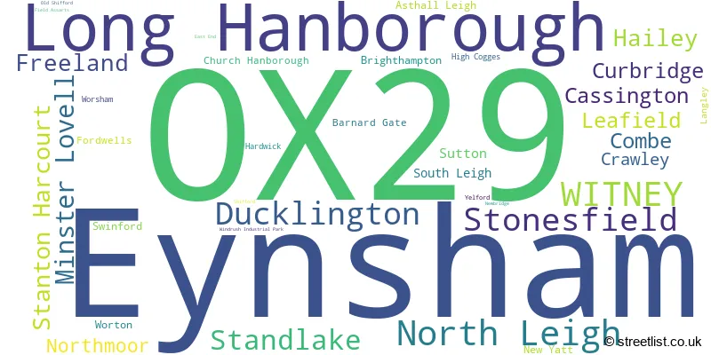
The largest settlement in the OX29 postal code is Eynsham followed by Long Hanborough, and WITNEY.
The OX29 Postcode shares a border with OX20 (WOODSTOCK, Bladon, Wootton), OX7 (CHIPPING NORTON, Charlbury, Milton-under-Wychwood), OX28 (WITNEY), OX13 (Steventon, Southmoor, Marcham), OX18 (CARTERTON, BAMPTON, BURFORD) and OX2 (OXFORD, Cumnor, Wolvercote).


Schools in the Sector
St Kenelm's Church of England (VC) School
Phase: Primary
Address: Wenrisc Drive , Minster Lovell , Witney
Postcode: OX29 0SP
Headteacher: Mrs Catherine Souch (Headteacher)
Ofsted Rating: Good
Bartholomew School
Phase: Secondary
Address: Witney Road , Eynsham , Witney
Postcode: OX29 4AP
Headteacher: Mr Craig Thomas (Headteacher)
Ofsted Rating: Outstanding
St Peter's Church of England Primary School, Cassington
Phase: Primary
Address: The Green , Cassington , Witney
Postcode: OX29 4DN
Headteacher: Mr Jon Jeffries (Headteacher)
Ofsted Rating: Good
Eynsham Community Primary School
Phase: Primary
Address: Beech Road , Eynsham , Witney
Postcode: OX29 4LJ
Headteacher: Mrs Virginia Bayliss ()
Ofsted Rating: Good
Stanton Harcourt CofE Primary School
Phase: Primary
Address: Main Road , Stanton Harcourt , Witney
Postcode: OX29 5RJ
Headteacher: Mrs Karen Jupp (Headteacher)
Ofsted Rating: Outstanding
Stanton Harcourt CofE Primary School
Phase: Primary
Address: Main Road , Stanton Harcourt , Witney
Postcode: OX29 5RJ
Headteacher: Mrs Ginny Bayliss (Headteacher)
Ofsted Rating: Good
North Leigh Church of England School
Phase: Primary
Address: Park Road , North Leigh , Witney
Postcode: OX29 6SS
Headteacher: Mr Ben McPherson (Headteacher)
Ofsted Rating: Good
Mulberry Bush School
Phase: Not applicable
Address: Abingdon Road , Standlake , Witney
Postcode: OX29 7RW
Headteacher: Mrs Jessica Hooper (Headteacher)
Ofsted Rating: Outstanding
Standlake Church of England Primary School
Phase: Primary
Address: Standlake , Witney
Postcode: OX29 7SQ
Headteacher: Mr Andrew Denham (Headteacher)
Ofsted Rating: Good
Ducklington Primary School
Phase: Primary
Address: Aston Road , Ducklington , Witney
Postcode: OX29 7US
Headteacher: Mr Russell Leigh (Headteacher)
Ofsted Rating: Good
Hanborough Manor CofE School
Phase: Primary
Address: Riely Close , Long Hanborough , Witney
Postcode: OX29 8DJ
Headteacher: Mrs Sarah Nickelson (Headteacher (Acting))
Ofsted Rating: Good
Freeland Church of England Primary School
Phase: Primary
Address: Parklands , Freeland , Freeland Primary School , Witney
Postcode: OX29 8HX
Headteacher: Mrs Penny McCarthy (Headteacher)
Ofsted Rating: Good
Combe CofE Primary School
Phase: Primary
Address: Church Walk , Combe , Witney
Postcode: OX29 8NQ
Headteacher: Mrs Rachel Joannou (Headteacher)
Ofsted Rating: Good
Stonesfield Primary School
Phase: Primary
Address: High Street , Stonesfield , Witney
Postcode: OX29 8PU
Headteacher: Headteacher Matt Jarvis (Headteacher)
Ofsted Rating: Good
Leafield Church of England (Controlled) Primary School
Phase: Primary
Address: The Green , Leafield , Witney
Postcode: OX29 9NP
Headteacher: Mr Christian McGuinness (Headteacher)
Ofsted Rating: Good
Leafield Church of England Primary School
Phase: Primary
Address: The Green , Leafield , Witney
Postcode: OX29 9NP
Headteacher: Ms Faye Dean (Headteacher)
Ofsted Rating: Good
Hailey Church of England Primary School
Phase: Primary
Address: Hailey , Witney
Postcode: OX29 9UB
Headteacher: Mrs Deborah Davies (Headteacher)
Ofsted Rating: Good
Stations in the Sector
Hanborough
CRS Code: HND
Operator: GW
Line: Cotswold Line
Company: Great Western Railway
Accessable Motorway Junctions
M40 J9
Average Driving Time from within the district: 18.37
Average Driving Distance: 14.94
Number of Postcodes that can access the Motorway Junction: 981
M40 J8A
Average Driving Time from within the district: 22.57
Average Driving Distance: 17.71
Number of Postcodes that can access the Motorway Junction: 981
M40 J10
Average Driving Time from within the district: 23.20
Average Driving Distance: 19.31
Number of Postcodes that can access the Motorway Junction: 971
M40 J7
Average Driving Time from within the district: 24.26
Average Driving Distance: 18.66
Number of Postcodes that can access the Motorway Junction: 683
M4 J15
Average Driving Time from within the district: 32.79
Average Driving Distance: 24.87
Number of Postcodes that can access the Motorway Junction: 137
M4 J14
Average Driving Time from within the district: 33.86
Average Driving Distance: 22.97
Number of Postcodes that can access the Motorway Junction: 3
M40 J11
Average Driving Time from within the district: 34.00
Average Driving Distance: 21.75
Number of Postcodes that can access the Motorway Junction: 174
M4 J16
Average Driving Time from within the district: 38.34
Average Driving Distance: 26.27
Number of Postcodes that can access the Motorway Junction: 6
Weather Forecast for Witney
| Time Period | Icon | Description | Temperature | Rain Probability | Wind |
|---|---|---|---|---|---|
| 12:00 to 15:00 | Cloudy | 14.0°C (feels like 13.0°C) | 6.00% | WSW 11 mph | |
| 15:00 to 18:00 | Partly cloudy (day) | 15.0°C (feels like 14.0°C) | 5.00% | WSW 7 mph | |
| 18:00 to 21:00 | Clear night | 12.0°C (feels like 11.0°C) | 0.00% | SW 4 mph | |
| 21:00 to 00:00 | Clear night | 10.0°C (feels like 9.0°C) | 0.00% | SW 4 mph |
| Time Period | Icon | Description | Temperature | Rain Probability | Wind |
|---|---|---|---|---|---|
| 00:00 to 03:00 | Partly cloudy (night) | 8.0°C (feels like 7.0°C) | 1.00% | SW 4 mph | |
| 03:00 to 06:00 | Mist | 8.0°C (feels like 7.0°C) | 13.00% | SW 2 mph | |
| 06:00 to 09:00 | Fog | 8.0°C (feels like 7.0°C) | 15.00% | S 2 mph | |
| 09:00 to 12:00 | Cloudy | 10.0°C (feels like 9.0°C) | 5.00% | S 4 mph | |
| 12:00 to 15:00 | Cloudy | 15.0°C (feels like 13.0°C) | 6.00% | SSW 9 mph | |
| 15:00 to 18:00 | Cloudy | 15.0°C (feels like 14.0°C) | 6.00% | S 9 mph | |
| 18:00 to 21:00 | Clear night | 12.0°C (feels like 11.0°C) | 0.00% | SSE 7 mph | |
| 21:00 to 00:00 | Clear night | 10.0°C (feels like 9.0°C) | 0.00% | SSE 7 mph |
| Time Period | Icon | Description | Temperature | Rain Probability | Wind |
|---|---|---|---|---|---|
| 00:00 to 03:00 | Partly cloudy (night) | 10.0°C (feels like 8.0°C) | 1.00% | SE 7 mph | |
| 03:00 to 06:00 | Clear night | 10.0°C (feels like 8.0°C) | 1.00% | SE 9 mph | |
| 06:00 to 09:00 | Clear night | 10.0°C (feels like 8.0°C) | 1.00% | SE 9 mph | |
| 09:00 to 12:00 | Overcast | 12.0°C (feels like 10.0°C) | 7.00% | SSE 11 mph | |
| 12:00 to 15:00 | Overcast | 15.0°C (feels like 12.0°C) | 9.00% | SSE 13 mph | |
| 15:00 to 18:00 | Cloudy | 15.0°C (feels like 13.0°C) | 6.00% | S 13 mph | |
| 18:00 to 21:00 | Cloudy | 14.0°C (feels like 12.0°C) | 10.00% | SSE 11 mph | |
| 21:00 to 00:00 | Cloudy | 14.0°C (feels like 12.0°C) | 21.00% | S 13 mph |
| Time Period | Icon | Description | Temperature | Rain Probability | Wind |
|---|---|---|---|---|---|
| 00:00 to 03:00 | Light rain shower (night) | 14.0°C (feels like 11.0°C) | 44.00% | SSW 11 mph | |
| 03:00 to 06:00 | Light rain shower (night) | 12.0°C (feels like 10.0°C) | 38.00% | SSW 11 mph | |
| 06:00 to 09:00 | Clear night | 10.0°C (feels like 8.0°C) | 8.00% | SSW 9 mph | |
| 09:00 to 12:00 | Sunny day | 11.0°C (feels like 9.0°C) | 7.00% | SSW 11 mph | |
| 12:00 to 15:00 | Light rain shower (day) | 12.0°C (feels like 10.0°C) | 36.00% | SW 13 mph | |
| 15:00 to 18:00 | Light rain shower (day) | 12.0°C (feels like 10.0°C) | 35.00% | SW 11 mph | |
| 18:00 to 21:00 | Clear night | 10.0°C (feels like 8.0°C) | 6.00% | WSW 9 mph | |
| 21:00 to 00:00 | Clear night | 9.0°C (feels like 6.0°C) | 4.00% | SW 11 mph |
| Time Period | Icon | Description | Temperature | Rain Probability | Wind |
|---|---|---|---|---|---|
| 00:00 to 03:00 | Clear night | 8.0°C (feels like 6.0°C) | 4.00% | SW 9 mph | |
| 03:00 to 06:00 | Clear night | 8.0°C (feels like 5.0°C) | 6.00% | SW 11 mph | |
| 06:00 to 09:00 | Cloudy | 8.0°C (feels like 6.0°C) | 11.00% | SW 11 mph | |
| 09:00 to 12:00 | Cloudy | 10.0°C (feels like 8.0°C) | 12.00% | SW 11 mph | |
| 12:00 to 15:00 | Cloudy | 12.0°C (feels like 10.0°C) | 18.00% | SW 13 mph | |
| 15:00 to 18:00 | Cloudy | 13.0°C (feels like 10.0°C) | 34.00% | SW 11 mph | |
| 18:00 to 21:00 | Cloudy | 12.0°C (feels like 9.0°C) | 11.00% | SW 11 mph | |
| 21:00 to 00:00 | Clear night | 11.0°C (feels like 9.0°C) | 6.00% | SW 11 mph |
| Postal Sector | Delivery Office |
|---|---|
| OX29 0 | Witney Delivery Office |
| OX29 4 | Witney Delivery Office |
| OX29 5 | Witney Delivery Office |
| OX29 6 | Witney Delivery Office |
| OX29 7 | Witney Delivery Office |
| OX29 8 | Witney Delivery Office |
| OX29 9 | Witney Delivery Office |
| O | X | 2 | 9 | - | X | X | X |
| O | X | 2 | 9 | Space | Numeric | Letter | Letter |
Tourist Attractions
We found 1 visitor attractions.
| Oxford Bus Museum Trust |
|---|
| Museums & Art Galleries |
| Museum and / or Art Gallery |
| View Oxford Bus Museum Trust on Google Maps |
Street List for the OX29 District
Current Monthly Rental Prices
| # Bedrooms | Min Price | Max Price | Avg Price |
|---|---|---|---|
| 1 | £695 | £3,250 | £2,049 |
| 2 | £1,095 | £6,067 | £2,083 |
| 3 | £1,400 | £2,250 | £1,686 |
| 4 | £2,250 | £6,995 | £4,915 |
| 5 | £2,500 | £3,800 | £3,150 |
Current House Prices
| # Bedrooms | Min Price | Max Price | Avg Price |
|---|---|---|---|
| £300,000 | £1,500,000 | £693,750 | |
| 1 | £102,500 | £475,000 | £236,136 |
| 2 | £126,000 | £475,000 | £306,000 |
| 3 | £148,000 | £800,000 | £422,651 |
| 4 | £375,000 | £1,800,000 | £705,279 |
| 5 | £585,000 | £1,625,000 | £966,174 |
| 6 | £1,350,000 | £1,900,000 | £1,580,000 |
Estate Agents
| Logo | Name | Brand Name | Address | Contact Number |
|---|---|---|---|---|
 | Witney | Chancellors | 14 Corn Street, Witney, OX28 6BL | 01993 225913 |
 | Witney | Breckon & Breckon | 10 Market Square, Witney, OX28 6BB | 01993 225879 |
 | Witney | Scottfraser | 38, Market Square, Witney, OX28 6AL | 01993 225872 |
 | Woodstock | Flowers Estate Agents | London House 16 Oxford Street Woodstock OX20 1TS | 01993 225812 |
 | Witney | Thomas Merrifield | 52 Market Square, Witney, OX28 6AF | 01993 772000 |
- Asthall
- Aston
- Brighthampton
- Cassington
- Church Hanborough
- Combe
- Cote
- Crawley
- Curbridge
- Delly End
- Ducklington
- East End
- Eynsham
- Farmoor
- Fawler
- Fordwells
- Freeland
- Hailey
- High Cogges
- Leafield
- Long Hanborough
- Minster Lovell
- New Yatt
- North Leigh
- Northmoor
- Poffley End
- South Leigh
- Standlake
- Stanton Harcourt
- Stonesfield
- Sutton
- Swinbrook
- Swinford
- The Green
- Witney
- Yarnton
Yearly House Price Averages for the District
| Type of Property | 2018 Average | 2018 Sales | 2017 Average | 2017 Sales | 2016 Average | 2016 Sales | 2015 Average | 2015 Sales |
|---|---|---|---|---|---|---|---|---|
| Detached | £551,187 | 219 | £564,342 | 135 | £533,195 | 139 | £494,556 | 128 |
| Semi-Detached | £346,970 | 118 | £376,026 | 79 | £359,511 | 81 | £319,976 | 86 |
| Terraced | £344,715 | 94 | £312,274 | 57 | £327,212 | 70 | £285,974 | 98 |
| Flats | £241,421 | 14 | £233,212 | 16 | £190,563 | 8 | £197,407 | 22 |