The OX29 7 postcode sector is within the county of Oxfordshire.
Did you know? According to the 2021 Census, the OX29 7 postcode sector is home to a bustling 5,028 residents!
Given that each sector allows for 400 unique postcode combinations. Letters C, I, K, M, O and V are not allowed in the last two letters of a postcode. With 180 postcodes already in use, this leaves 220 units available.
The largest settlement in the OX29 7 postal code is WITNEY followed by Ducklington, and Standlake.
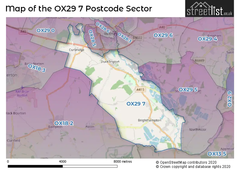
The OX29 7 Postcode shares a border with OX28 5 (WITNEY, Richmond Village), OX13 5 (Southmoor, Kingston Bagpuize, Longworth), OX28 4 (WITNEY), OX18 2 (BAMPTON, Aston, Clanfield), OX18 3 (CARTERTON, Brize Norton), OX28 3 (WITNEY), OX29 0 (Minster Lovell, Curbridge, WITNEY), OX29 5 (Stanton Harcourt, Northmoor, Sutton) and OX29 6 (North Leigh, South Leigh, New Yatt).
The sector is within the post town of WITNEY.
OX29 7 is a postcode sector within the OX29 postcode district which is within the OX Oxford postcode area.
The Royal Mail delivery office for the OX29 7 postal sector is the Witney Delivery Office.
The area of the OX29 7 postcode sector is 13.47 square miles which is 34.88 square kilometres or 8,619.36 square acres.
Waterways within the OX29 7 postcode sector include the River Thames, Em's Ditch, Em's Ditch (Emma's Dike), Windrush, Collwell Brook.

Map of the OX29 7 Postcode Sector
Explore the OX29 7 postcode sector by using our free interactive map.
| O | X | 2 | 9 | - | 7 | X | X |
| O | X | 2 | 9 | Space | 7 | Letter | Letter |
Official List of Streets
Standlake (21 Streets)
WITNEY (38 Streets)
Brighthampton (4 Streets)
Ducklington (29 Streets)
Curbridge (8 Streets)
Yelford (1 Streets)
Windrush Industrial Park (1 Streets)
Unofficial Streets or Alternative Spellings
WITNEY
COLLETTS WAY DE HAVILLAND WAY RALEGH CRESCENT RANGE ROAD THORNEY LEYS ABINGDON LANE ASTON MILE BELL INN CASWELL LANE CLOVER LANE CORAL SPRINGS COTE MILE CRIFT LANE CURBRIDGE FARM CURBRIDGE PARK ROAD DEER PARK ROAD DEER PARK WOOD PATH DOVECOT PLACE EASTWOOD ROAD ELMBANK COURT FURROW CRESCENT GLENMORE BUSINESS CENTRE GRASSLAND CLOSE HAY LANE HORNS WAY LANGLEYS LANE MARTINS LANE MILL HOUSE MILNE TIMBER SYSTEMS NEWBRIDGE NORTHERN CROSS VALLEY WAY PHILIP DENNIS FOODSERVICE RYE CRESENT RYE CRESENT (EVENS) RYE CRESENT (ODDS) SOUTHWOOD ROAD SPRING MEADOW THE FURLONG WESLEY BARRELL WESTWOOD ROAD WINDRUSH PATH WITNEY LAKE AND MEADOWS TRAIL WITNEY LAKES RESORT ONLYCurbridge
PLOUGH CLOSE RYE CRESCENT WHEATFIELD DRIVEMinster Lovell
DOWNS ROADNorthmoor
MORETON LANE STANDLAKE ROADRichmond Village
CORAL SPRINGS WAYSchools and Places of Education Within the OX29 7 Postcode Sector
Ducklington Primary School
Voluntary controlled school
Aston Road, Witney, Oxfordshire, OX29 7US
Head: Mr Russell Leigh
Ofsted Rating: Good
Inspection: 2023-03-29 (434 days ago)
Website: Visit Ducklington Primary School Website
Phone: 01993703651
Number of Pupils: 211
Mulberry Bush School
Non-maintained special school
Abingdon Road, Witney, Oxfordshire, OX29 7RW
Head: Mrs Jessica Hooper
Ofsted Rating: Outstanding
Inspection: 2023-03-29 (434 days ago)
Website: Visit Mulberry Bush School Website
Phone: 01865300202
Number of Pupils: 22
Standlake Church of England Primary School
Academy converter
Standlake, Witney, Oxfordshire, OX29 7SQ
Head: Mr Andrew Denham
Ofsted Rating: Good
Inspection: 2023-01-18 (504 days ago)
Website: Visit Standlake Church of England Primary School Website
Phone: 01865300454
Number of Pupils: 132
House Prices in the OX29 7 Postcode Sector
| Type of Property | 2018 Average | 2018 Sales | 2017 Average | 2017 Sales | 2016 Average | 2016 Sales | 2015 Average | 2015 Sales |
|---|---|---|---|---|---|---|---|---|
| Detached | £492,939 | 95 | £548,071 | 33 | £493,792 | 29 | £472,953 | 25 |
| Semi-Detached | £334,519 | 51 | £371,378 | 7 | £355,417 | 6 | £326,333 | 9 |
| Terraced | £349,531 | 20 | £327,500 | 4 | £317,833 | 9 | £257,425 | 12 |
| Flats | £183,000 | 1 | £260,333 | 3 | £0 | 0 | £242,500 | 2 |
Important Postcodes OX29 7 in the Postcode Sector
OX29 7DL is the postcode for Windrush Church Of England Primary School, Isabelle Spencer Way
OX29 7QG is the postcode for Oxfordshire County Council, Oxfordshire Museum Store, Cotswold Dene
OX29 7SQ is the postcode for Standlake C of E School, Church Green, and Standlake Church Of England School, Church End
OX29 7US is the postcode for Ducklington C of E New Primary School, Aston Road, and Ducklington Primary School, Aston Road, Ducklington
| The OX29 7 Sector is within these Local Authorities |
|
|---|---|
| The OX29 7 Sector is within these Counties |
|
| The OX29 7 Sector is within these Water Company Areas |
|