Given that each sector allows for 400 unique postcode combinations. Letters C, I, K, M, O and V are not allowed in the last two letters of a postcode. With 235 postcodes already in use, this leaves 165 units available.
The largest settlement in the PA34 4 postal code is OBAN followed by Kilmelford, and Kilmore.
The PA34 4 Postcode shares a border with PA31 8 (LOCHGILPHEAD, Tayvallich, Kilmartin), PA34 5 (OBAN, Lismore), PA35 1 (TAYNUILT, Kilchrenan, Dalavich) and PA37 1 (Dunbeg, Benderloch, Connel).
The sector is within the post town of OBAN.
PA34 4 is a postcode sector within the PA34 postcode district which is within the PA Paisley postcode area.
The Royal Mail delivery office for the PA34 4 postal sector is the Easdale Scale Payment Delivery Office and Cullipool Scale Payment Delivery Office and Oban Delivery Office.
The area of the PA34 4 postcode sector is 130.81 square miles which is 338.80 square kilometres or 83,718.96 square acres.


Map of the PA34 4 Postcode Sector
Explore the PA34 4 postcode sector by using our free interactive map.
| P | A | 3 | 4 | - | 4 | X | X |
| P | A | 3 | 4 | Space | 4 | Letter | Letter |
Official List of Streets
OBAN (103 Streets)
Kilmore (4 Streets)
Toberonochy (4 Streets)
Kilmelford (4 Streets)
Easdale (2 Streets)
Clachan Seil (2 Streets)
Unofficial Streets or Alternative Spellings
OBAN
POLVINISTER ROAD QUEENS PARK PLACE AIRDS CRESCENT AIRDS PLACE ALMA CRESCENT ANT TRAIL BEN CRUACHAN VIEW BURNSIDE COURT CLACHAN BRIDGE CLAREMONT LANE CNOC A CHALLTUINN CRAIGHOUSE AVENUE CRANNAG A MHINISTEIR CRANNAG AMHINISTEIR CREAG AN AIRM CREAG BHAN VILLAGE CREAGBHAN VILLAGE CUAN FERRY DUNGALLAN TERRACE DUNMAR COURT GATE 1 GATE 2 GLEN LONAN GLEN LONAN ROAD GLENGALLEN DRIVE GLENGALLEN ROAD LERAGS ROAD LOCHAVULIN ROAD LUING FERRY MCKELVIE HEIGHTS OLD COFFIN ROAD PLADDA ROAD PULPIT HILL ST. VALERY PLACE THE GREENS TRAMWAY COTTAGES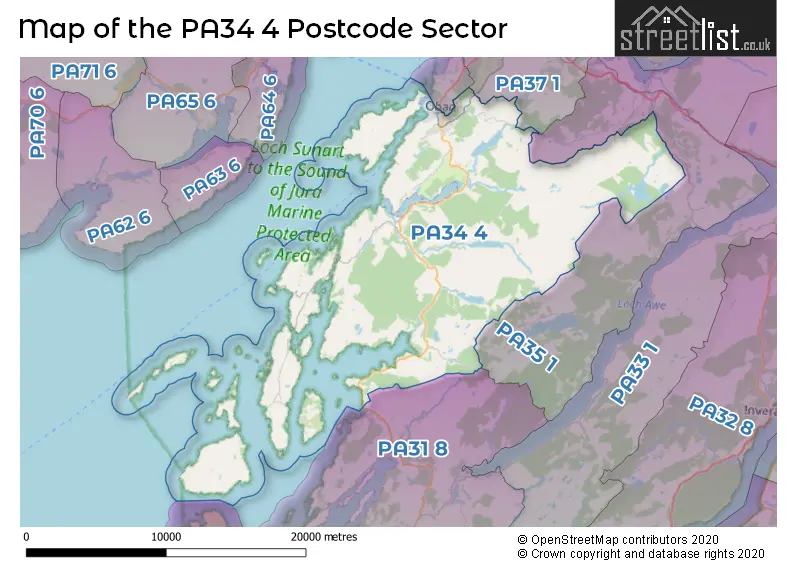
| The PA34 4 Sector is within these Local Authorities | |
|---|---|
| The PA34 4 Sector is within these Counties | |
| The PA34 4 Sector is within these Water Company Areas |