The PE29 1 postcode sector is within the county of Cambridgeshire.
Did you know? According to the 2021 Census, the PE29 1 postcode sector is home to a bustling 12,529 residents!
Given that each sector allows for 400 unique postcode combinations. Letters C, I, K, M, O and V are not allowed in the last two letters of a postcode. With 253 postcodes already in use, this leaves 147 units available.
The largest settlements in the PE29 1 postal code are HUNTINGDON and Hartford.
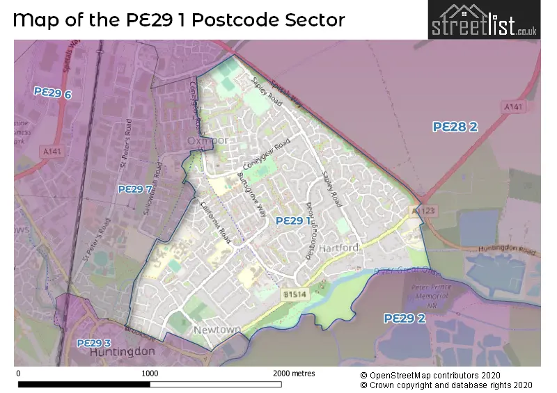
The PE29 1 Postcode shares a border with PE29 7 (HUNTINGDON), PE28 2 (Warboys, Wyton, Houghton), PE29 2 (Godmanchester) and PE29 3 (HUNTINGDON).
The sector is within the post town of HUNTINGDON.
PE29 1 is a postcode sector within the PE29 postcode district which is within the PE Peterborough postcode area.
The Royal Mail delivery office for the PE29 1 postal sector is the Huntingdon Delivery Office.
The area of the PE29 1 postcode sector is 1.14 square miles which is 2.95 square kilometres or 728.63 square acres.
Waterways within the PE29 1 postcode sector include the River Great Ouse.

Map of the PE29 1 Postcode Sector
Explore the PE29 1 postcode sector by using our free interactive map.
| P | E | 2 | 9 | - | 1 | X | X |
| P | E | 2 | 9 | Space | 1 | Letter | Letter |
Official List of Streets
HUNTINGDON (93 Streets)
Hartford (66 Streets)
Schools and Places of Education Within the PE29 1 Postcode Sector
Hartford Infant and Preschool
Academy converter
Mayfield Crescent, Huntingdon, Cambridgeshire, PE29 1UL
Head: Mrs Rae Lee
Ofsted Rating: Good
Inspection: 2023-03-22 (431 days ago)
Website: Visit Hartford Infant and Preschool Website
Phone: 01480398046
Number of Pupils: 202
Hartford Junior School
Academy sponsor led
Mayfield Crescent, Huntingdon, Cambridgeshire, PE29 1UL
Head: Mrs Rae Lee
Ofsted Rating: Good
Inspection: 2019-10-16 (1684 days ago)
Website: Visit Hartford Junior School Website
Phone: 01480454695
Number of Pupils: 227
Huntingdon Nursery School
Local authority nursery school
Ambury Road, Huntingdon, Cambridgeshire, PE29 1AD
Head: Ms Claire Palmer
Ofsted Rating: Good
Inspection: 2023-11-08 (200 days ago)
Website: Visit Huntingdon Nursery School Website
Phone: 01480375216
Number of Pupils: 85
Huntingdon Primary School
Community school
Ambury Road, Huntingdon, Cambridgeshire, PE29 1AD
Head: Ms Elaine Lynch
Ofsted Rating: Good
Inspection: 2018-03-15 (2264 days ago)
Website: Visit Huntingdon Primary School Website
Phone: 01480375113
Number of Pupils: 395
Spring Common Academy
Academy special converter
American Lane, Huntingdon, Cambridgeshire, PE29 1TQ
Head: Ms Rebecca Greig
Ofsted Rating: Outstanding
Inspection: 2018-11-27 (2007 days ago)
Website: Visit Spring Common Academy Website
Phone: 01480377403
Number of Pupils: 207
Thongsley Fields Primary and Nursery School
Academy sponsor led
Buttsgrove Way, Huntingdon, Cambridgeshire, PE29 1PE
Head: Mr David Jones
Ofsted Rating: Requires improvement
Inspection: 2023-01-18 (494 days ago)
Website: Visit Thongsley Fields Primary and Nursery School Website
Phone: 01480375321
Number of Pupils: 276
House Prices in the PE29 1 Postcode Sector
| Type of Property | 2018 Average | 2018 Sales | 2017 Average | 2017 Sales | 2016 Average | 2016 Sales | 2015 Average | 2015 Sales |
|---|---|---|---|---|---|---|---|---|
| Detached | £338,557 | 59 | £326,571 | 56 | £309,723 | 72 | £271,540 | 83 |
| Semi-Detached | £257,639 | 43 | £230,883 | 42 | £219,549 | 38 | £204,922 | 53 |
| Terraced | £194,587 | 63 | £181,151 | 59 | £176,938 | 106 | £172,747 | 117 |
| Flats | £128,500 | 9 | £121,244 | 9 | £158,814 | 14 | £121,594 | 9 |
Important Postcodes PE29 1 in the Postcode Sector
PE29 1AD is the postcode for Huntingdon Nursery School, Ambury Road, and Huntingdon Primary School, Ambury Road
PE29 1BL is the postcode for CONSTRUCTION FACILITY, Huntingdonshire Regional College, California Road, and Huntingdonshire Regional College, California Road
PE29 1JE is the postcode for Huntingdon Community Centre, 12a Ambury Road
PE29 1JT is the postcode for 6, St. Lukes Close
PE29 1LY is the postcode for Hillrise Childrens Home, Hill Rise, Buttsgrove Way, Cambridgeshire County Council, Buttsgrove Centre, Buttsgrove Way, BUTTSGROVE CENTRE, BUTTSGROVE WAY, HUNTINGDON, and Buttsgrove Centre, 38 Buttsgrove Way
PE29 1PE is the postcode for Thongsley Fields Primary School, Buttsgrove Way, and Thongsley County Junior & Infant School, Buttsgrove Way
PE29 1SF is the postcode for Medway Centre, Medway Road
PE29 1TQ is the postcode for SPRING COMMON LOWER SCHOOL, Spring Common Academy, American Lane, SPRING COMMON UPPER SCHOOL, Spring Common Academy, American Lane, Spring Common Academy, American Lane, SPRING COMMON UPPER SCHOOL, Spring Common School, American Lane, and Spring Common School, American Lane
PE29 1UL is the postcode for Hartford Community Infant School, Mayfield Road, HARTFORD COMMUNITY JUNIOR SCHOOL, MAYFIELD CRESCENT, HUNTINGDON, and Hartford Community Junior School, Mayfield Road
| The PE29 1 Sector is within these Local Authorities |
|
|---|---|
| The PE29 1 Sector is within these Counties |
|
| The PE29 1 Sector is within these Water Company Areas |
|