The PL11 postcode district is a postal district located in the PL Plymouth postcode area with a population of 10,307 residents according to the 2021 England and Wales Census.
The area of the PL11 postcode district is 16.45 square miles which is 42.59 square kilometres or 10,524.97 acres.
Currently, the PL11 district has about 325 postcode units spread across 2 geographic postcode sectors.
Given that each sector allows for 400 unique postcode combinations, the district has a capacity of 800 postcodes. With 325 postcodes already in use, this leaves 475 units available.
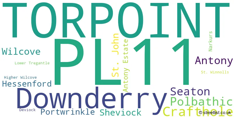
The largest settlement in the PL11 postal code is TORPOINT followed by Downderry, and Seaton.
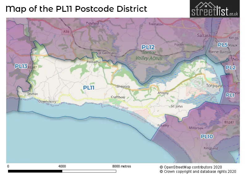
The postcode area has a boundary with The English Channel and Plymouth Sound.
The PL11 Postcode shares a border with PL10 (Millbrook, Cawsand, Kingsand), PL12 (SALTASH, Latchbrook, Landrake) and PL13 (LOOE, Polperro, Pelynt).
In the PL11 postcode district, the primary settlement is Torpoint, located in the county of Cornwall in England. Other significant settlements in this postcode district include Antony Estate, Higher Wilcove, Wilcove, Crafthole, Deviock, Downderry, Hessenford, Lower Tregantle, Narkurs, Polbathic, Portwrinkle, Seaton, Sheviock, St. John, and St. Winnolls. The most significant post town in this postcode district is Torpoint.
For the district PL11, we have data on 2 postcode sectors. Here's a breakdown: The sector PL11 2, covers Torpoint in Cornwall. The sector PL11 3, covers Downderry and Torpoint and Crafthole in Cornwall.

Map of the PL11 Postcode District
Explore the PL11 postcode district by using our free interactive map.
When it comes to local government, postal geography often disregards political borders. However, for a breakdown in the PL11 District: the district mostly encompasses the Cornwall area with a total of 325 postcodes.
Recent House Sales in PL11
| Date | Price | Address |
|---|---|---|
| 20/10/2023 | £255,000 | Trevithick Avenue, Torpoint, PL11 2PX |
| 28/09/2023 | £570,000 | Buttlegate, Downderry, Torpoint, PL11 3NQ |
| 12/09/2023 | £200,000 | Clarence Road, Torpoint, PL11 2LT |
| 06/09/2023 | £250,000 | Woodland Way, Torpoint, PL11 2DW |
| 29/08/2023 | £350,000 | Keveral Gardens, Seaton, Torpoint, PL11 3JH |
| 25/08/2023 | £200,000 | Clarence Road, Torpoint, PL11 2LT |
| 25/08/2023 | £325,000 | Chapeldown Road, Torpoint, PL11 2HT |
| 24/08/2023 | £605,000 | Downderry, Torpoint, PL11 3LL |
| 18/08/2023 | £115,000 | Adams Crescent, Torpoint, PL11 2DP |
| 16/08/2023 | £460,000 | Narkurs, Torpoint, PL11 3DW |
Weather Forecast for PL11
Press Button to Show Forecast for Portwrinkle (Beach)
| Time Period | Icon | Description | Temperature | Rain Probability | Wind |
|---|---|---|---|---|---|
| 03:00 to 06:00 | Cloudy | 5.0°C (feels like 4.0°C) | 6.00% | N 4 mph | |
| 06:00 to 09:00 | Cloudy | 6.0°C (feels like 5.0°C) | 8.00% | NNE 4 mph | |
| 09:00 to 12:00 | Cloudy | 9.0°C (feels like 8.0°C) | 11.00% | E 7 mph | |
| 12:00 to 15:00 | Cloudy | 10.0°C (feels like 8.0°C) | 20.00% | ESE 9 mph | |
| 15:00 to 18:00 | Light rain shower (day) | 10.0°C (feels like 8.0°C) | 40.00% | ESE 9 mph | |
| 18:00 to 21:00 | Light rain | 9.0°C (feels like 7.0°C) | 49.00% | E 9 mph | |
| 21:00 to 00:00 | Cloudy | 8.0°C (feels like 6.0°C) | 16.00% | ENE 7 mph |
Press Button to Show Forecast for Portwrinkle (Beach)
| Time Period | Icon | Description | Temperature | Rain Probability | Wind |
|---|---|---|---|---|---|
| 00:00 to 03:00 | Cloudy | 7.0°C (feels like 5.0°C) | 16.00% | NE 9 mph | |
| 03:00 to 06:00 | Cloudy | 7.0°C (feels like 5.0°C) | 11.00% | NE 9 mph | |
| 06:00 to 09:00 | Cloudy | 7.0°C (feels like 5.0°C) | 11.00% | NE 9 mph | |
| 09:00 to 12:00 | Cloudy | 9.0°C (feels like 7.0°C) | 11.00% | ENE 11 mph | |
| 12:00 to 15:00 | Cloudy | 11.0°C (feels like 9.0°C) | 12.00% | ENE 11 mph | |
| 15:00 to 18:00 | Overcast | 11.0°C (feels like 9.0°C) | 15.00% | NE 13 mph | |
| 18:00 to 21:00 | Cloudy | 10.0°C (feels like 8.0°C) | 17.00% | NE 13 mph | |
| 21:00 to 00:00 | Cloudy | 9.0°C (feels like 6.0°C) | 15.00% | NNE 13 mph |
Press Button to Show Forecast for Portwrinkle (Beach)
| Time Period | Icon | Description | Temperature | Rain Probability | Wind |
|---|---|---|---|---|---|
| 00:00 to 03:00 | Light rain | 8.0°C (feels like 5.0°C) | 46.00% | NNE 13 mph | |
| 03:00 to 06:00 | Light rain | 8.0°C (feels like 4.0°C) | 49.00% | N 13 mph | |
| 06:00 to 09:00 | Light rain | 7.0°C (feels like 4.0°C) | 47.00% | N 13 mph | |
| 09:00 to 12:00 | Light rain | 9.0°C (feels like 6.0°C) | 44.00% | N 16 mph | |
| 12:00 to 15:00 | Cloudy | 11.0°C (feels like 8.0°C) | 16.00% | NW 16 mph | |
| 15:00 to 18:00 | Cloudy | 11.0°C (feels like 9.0°C) | 15.00% | NW 16 mph | |
| 18:00 to 21:00 | Partly cloudy (day) | 10.0°C (feels like 8.0°C) | 6.00% | NW 11 mph | |
| 21:00 to 00:00 | Clear night | 7.0°C (feels like 5.0°C) | 2.00% | WNW 7 mph |
Where is the PL11 Postcode District?
The postcode district PL11 is located in Torpoint. Torpoint is situated in close proximity to several nearby towns. To the north of Torpoint is Saltash, which is approximately 3.4 miles away. To the west is Looe, which is around 7.2 miles away. On the east side is Plymouth, which is approximately 8.4 miles away. Additionally, Calstock is located to the northeast, around 9.7 miles away, and Liskeard is situated to the northwest, around 11.1 miles away from Torpoint. Furthermore, Torpoint is located approximately 198.4 miles away from the center of London.
The district is within the post town of TORPOINT.
The sector has postcodes within the nation of England.
The PL11 Postcode District is in the Cornwall and Isles of Scilly region of Cornwall and Isles of Scilly within the South West (England).
| Postcode Sector | Delivery Office |
|---|---|
| PL11 2 | Torpoint Scale Payment Delivery Office |
| PL11 3 | Torpoint Scale Payment Delivery Office |
| P | L | 1 | 1 | - | X | X | X |
| P | L | 1 | 1 | Space | Numeric | Letter | Letter |
Tourist Attractions within the Postcode Area
We found 1 visitor attractions within the PL11 postcode area
| Antony House and Garden |
|---|
| Historic Properties |
| Historic House / House and Garden / Palace |
| View Antony House and Garden on Google Maps |
Current Monthly Rental Prices
| # Bedrooms | Min Price | Max Price | Avg Price |
|---|---|---|---|
| £250 | £250 | £250 | |
| 1 | £650 | £650 | £650 |
| 2 | £755 | £1,400 | £1,078 |
Current House Prices
| # Bedrooms | Min Price | Max Price | Avg Price |
|---|---|---|---|
| £55,000 | £210,000 | £132,500 | |
| 1 | £90,000 | £175,000 | £120,000 |
| 2 | £85,000 | £775,000 | £214,250 |
| 3 | £160,000 | £895,000 | £339,032 |
| 4 | £350,000 | £1,500,000 | £838,571 |
| 5 | £250,000 | £1,250,000 | £668,750 |
| 6 | £685,000 | £3,000,000 | £1,842,500 |
Estate Agents who Operate in the PL11 District
| Logo | Name | Brand Name | Address | Contact Number | Total Properties |
|---|---|---|---|---|---|
 | Torpoint | Ideal Homes | Torpoint, | 01752 812333 | 36 |
 | Cornwall | Scott Parry Associates | TAMAR VIEW NURSERIES Carkeel, Saltash, PL12 6PH | 01752 858314 | 18 |
 | Torpoint | Miller Countrywide | 67 Fore Street, Torpoint, Cornwall, PL11 2AA | 01752 741344 | 9 |
 | Torpoint | Ideal Homes | 1 Fore Street, Torpoint, PL11 2AA | 01752 741641 | 3 |
 | Cornwall | Homes by Stephens & Stephens | . | 01872 304078 | 2 |
| Type of Property | 2018 Average | 2018 Sales | 2017 Average | 2017 Sales | 2016 Average | 2016 Sales | 2015 Average | 2015 Sales |
|---|---|---|---|---|---|---|---|---|
| Detached | £400,024 | 42 | £369,253 | 59 | £312,211 | 50 | £319,153 | 50 |
| Semi-Detached | £204,892 | 37 | £196,898 | 55 | £166,508 | 46 | £174,548 | 61 |
| Terraced | £165,463 | 62 | £160,373 | 68 | £157,653 | 74 | £162,482 | 62 |
| Flats | £125,927 | 29 | £143,208 | 24 | £149,880 | 28 | £116,321 | 36 |