This section of the site is all about the PL Postcode area, also known as the Plymouth Postal Area. Explore links to the next level to learn more about specific postcode districts such as PL1.
The PL postcode area represents a group of postal districts in the Plymouth area of the United Kingdom. The area code PL stands for the letters p and l in PLymouth. PL has a population of 542,719 and covers an area of 2,864,956 hectares. Fun fact: 0.83% of the population of Great Britain lives in this area.
The postcode area falls within the following counties: Devon (52.90%), Cornwall (47.10%).
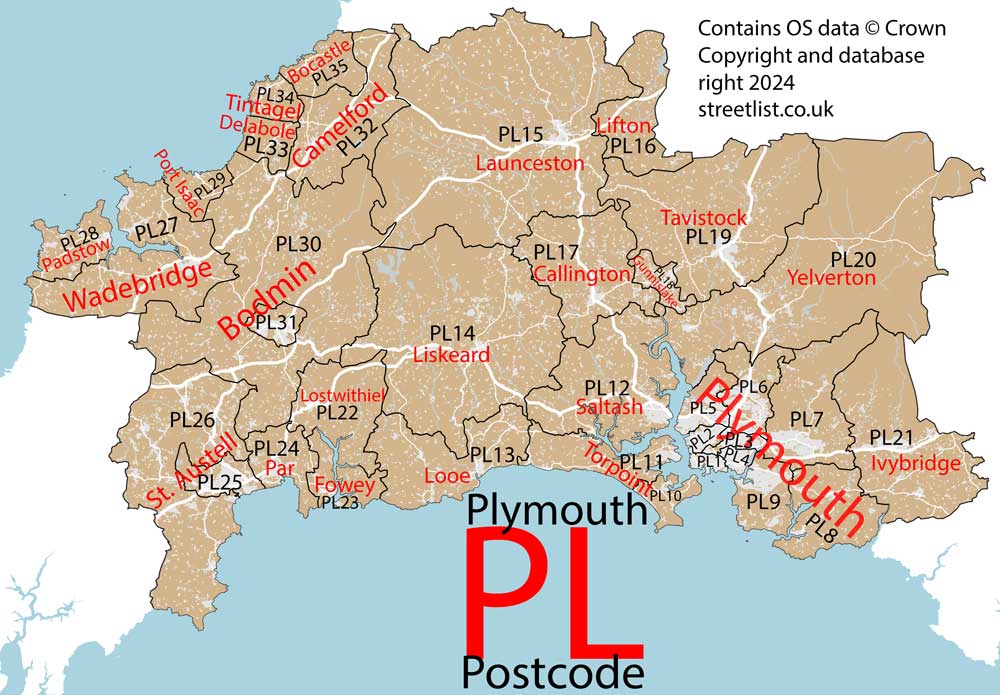
Post Towns and Postcode Districts for the PL Postcode
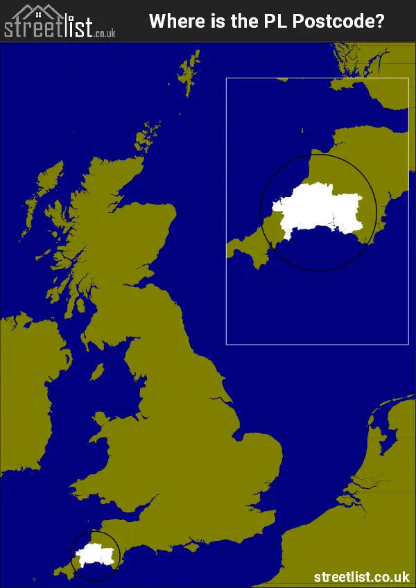
Where is the PL Postcode Area?
The PL Plymouth Postcode is in the South West of England. The postal area borders the following neighbouring postal areas: EX - Exeter, TQ - Torquay and TR - Truro, It also borders The Camel Estuary, Plymouth Sound, Fowey Estuary, The English Channel and The Celtic Sea.
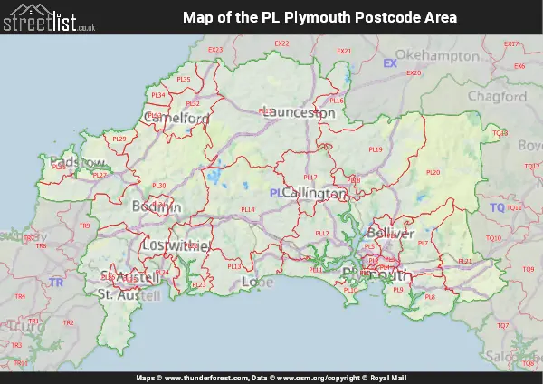
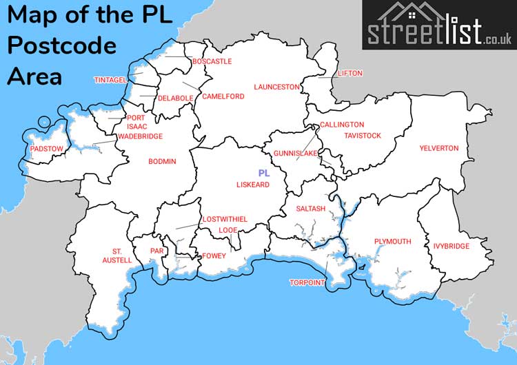
Map of the PL Plymouth Postcode Area
Explore the PL Plymouth postcode area by using our interactive map.
Postcode Districts within the PL Plymouth Postcode Area
There are 35 postcode districts within the Plymouth postcode area
A map showing the boundary of in relation to other areas
There are 16 towns within the Plymouth postcode area.

| Unit | Area² |
|---|---|
| Hectares | 2,864,956² |
| Miles | 11,062² |
| Feet | 308,380,998,884² |
| Kilometres | 28,650² |
Postal Delivery Offices serving the PL Plymouth Postcode Area
- Bere Alston Scale Payment Delivery Office
- Bodmin Delivery Office
- Boscastle Scale Payment Delivery Office
- Callington Delivery Office
- Camelford Scale Payment Delivery Office
- Delabole Scale Payment Delivery Office
- Fowey Scale Payment Delivery Office
- Ivybridge Delivery Office
- Launceston Delivery Office
- Liskeard Delivery Office
- Looe Delivery Office
- Lostwithiel Scale Payment Delivery Office
- Padstow Scale Payment Delivery Office
- Plymouth Delivery Office (2-3)
- Plymouth Postal Delivery Office
- Plympton Delivery Office
- Port Isaac Scale Payment Delivery Office
- Saltash Delivery Office
- St. Austell Delivery Office
- St. Eval Scale Payment Delivery Office
- Tavistock Delivery Office
- Tintagel Scale Payment Delivery Office
- Torpoint Scale Payment Delivery Office
- Trevone Scale Payment Delivery Office
- Wadebridge Delivery Office
- West Park Delivery Office
Councils with Postcodes in PL
Towns and Villages within the PL Plymouth Postcode Area
- Altarnun - village
- Antony - village
- Battisborough Cross - village
- Bere Alston - village
- Bere Ferrers - village
- Bickleigh - village
- Bittaford - village
- Blisland - village
- Bodieve - village
- Bodmin - town
- Boscastle - village
- Bossiney - village
- Botusfleming - village
- Boyton - village
- Bray Shop - village
- Brixton - village
- Buckland Monachorum - village
- Bugle - village
- Burlawn - village
- Burraton - village
- Callington - town
- Calstock - village
- Camelford - town
- Cardinham - village
- Carey Park - village
- Cargreen - village
- Carkeel - village
- Carlyon Bay - village
- Carpalla - village
- Cawsand - village
- Charlestown - village
- Chillaton - village
- Clampits - village
- Coad's Green - village
- Common Moor - village
- Constantine Bay - village
- Coombe - village
- Cornwood - village
- Crafthole - village
- Crapstone - village
- Darite - village
- Daw's House - village
- Delabole - village
- Dobwalls - village
- Doublebois - village
- Dousland - village
- Down Thomas - village
- Downderry - village
- Downgate - village
- Duloe - village
- Dunmere - village
- Duporth - village
- East Taphouse - village
- Egloshayle - village
- Egloskerry - village
- Ermington - village
- Fivelanes - village
- Freathy - village
- Golant - village
- Golberdon - village
- Gorran Haven - village
- Goverseth - village
- Grenofen - village
- Gunnislake - village
- Harlyn - village
- Harrowbarrow - village
- Hatt - village
- Helland - village
- Hemerdon - village
- Hessenford - village
- Heybrook Bay - village
- Higher Tremarcoombe - village
- Holbeton - village
- Hollacombe Hill - village
- Hornick - village
- Horrabridge - village
- Ivybridge - town
- Kelly Bray - village
- Kilhallon - village
- Kingsand - village
- Lamerton - village
- Landrake - village
- Lanivet - village
- Lanreath - village
- Launceston - town
- Lawhitton - village
- Lee Mill - village
- Lee Moor - village
- Lerryn - village
- Lewannick - village
- Lifton - village
- Liskeard - town
- Looe - town
- Lostwithiel - town
- Luckett - village
- Lutton - village
- Luxulyan - village
- Marshgate - village
- Mary Tavy - village
- Meavy - village
- Membland - village
- Menheniot - village
- Merrymeet - village
- Metherell - village
- Mevagissey - village
- Milton Abbot - village
- Milton Combe - village
- Minions - village
- Modbury - village
- Moorhaven Village - village
- Mount - village
- Nanpean - village
- Nanstallon - village
- New Polzeath - village
- Newton Ferrers - village
- No Man's Land - village
- Norris Green - village
- North Brentor - village
- North Hill - village
- North Petherwin - village
- Noss Mayo - village
- Padstow - town
- Par - village
- Pelynt - village
- Pendoggett - village
- Penrose - village
- Pensilva - village
- Pentewan - village
- Penwithick - village
- Peter Tavy - village
- Pillaton - village
- Pityme - village
- Plymouth - city
- Polbathic - village
- Polgooth - village
- Polperro - village
- Polruan - village
- Polyphant - village
- Polzeath - village
- Port Isaac - village
- Porthcothan - village
- Portwrinkle - village
- Princetown - village
- Quethiock - village
- Rilla Mill - village
- Roche - village
- Rock - village
- Rosecraddoc - village
- Rumford - village
- Saltash - town
- Seaton - village
- Shaugh Prior - village
- Sherford - town
- Sheviock - village
- South Petherwin - village
- Sparkwell - village
- St Ann's Chapel - village
- St Austell - town
- St Blazey - town
- St Breward - village
- St Cleer - village
- St Dennis - village
- St Dominick - village
- St Eval - village
- St Germans - village
- St Giles on the Heath - village
- St Issey - village
- St John - village
- St Kew Highway - village
- St Keyne - village
- St Mabyn - village
- St Mellion - village
- St Merryn - village
- St Minver - village
- St Neot - village
- St Stephen - village
- St Teath - village
- St Tudy - village
- Staddiscombe - village
- Stenalees - village
- Stepaside - village
- Stoke Climsland - village
- Tavistock - town
- Tideford - village
- Tinhay - village
- Tintagel - village
- Torpoint - town
- Trebetherick - village
- Treburley - village
- Tredinnick - village
- Tredrizzick - village
- Tregadillett - village
- Tregoodwell - village
- Tregorrick - village
- Tregrehan Mills - village
- Treknow - village
- Trelawne - village
- Trelights - village
- Trelowth - village
- Tremar - village
- Trematon - village
- Tresmeer - village
- Tresparrett - village
- Trethowel - village
- Trethurgy - village
- Treviscoe - village
- Trevone - village
- Trewarmett - village
- Trewidland - village
- Trewoon - village
- Treyarnon - village
- Trezaise - village
- Tywardreath - village
- Ugborough - village
- Upton Cross - village
- Venterdon - village
- Victoria - otherSettlement
- Wadebridge - town
- Walkhampton - village
- Warbstow - village
- Wembury - village
- Whitecross - village
- Whitemoor - village
- Widegates - village
- Wilcove - village
- Withnoe - village
- Wotter - village
- Yealmbridge - village
- Yealmpton - village
- Yelverton - village
- Yeolmbridge - village
- Yondertown - village