This section of the site is all about the EX Postcode area, also known as the Exeter Postal Area. Explore links to the next level to learn more about specific postcode districts such as EX1.
The EX postcode area represents a group of postal districts in the Exeter area of the United Kingdom. The area code EX stands for the letters e and x in EXeter. EX has a population of 547,511 and covers an area of 4,780,391 hectares. Fun fact: 0.84% of the population of Great Britain lives in this area.
The postcode area falls within the following counties: Devon (96.64%), Cornwall (3.32%), Somerset (0.03%), Dorset (0.01%).
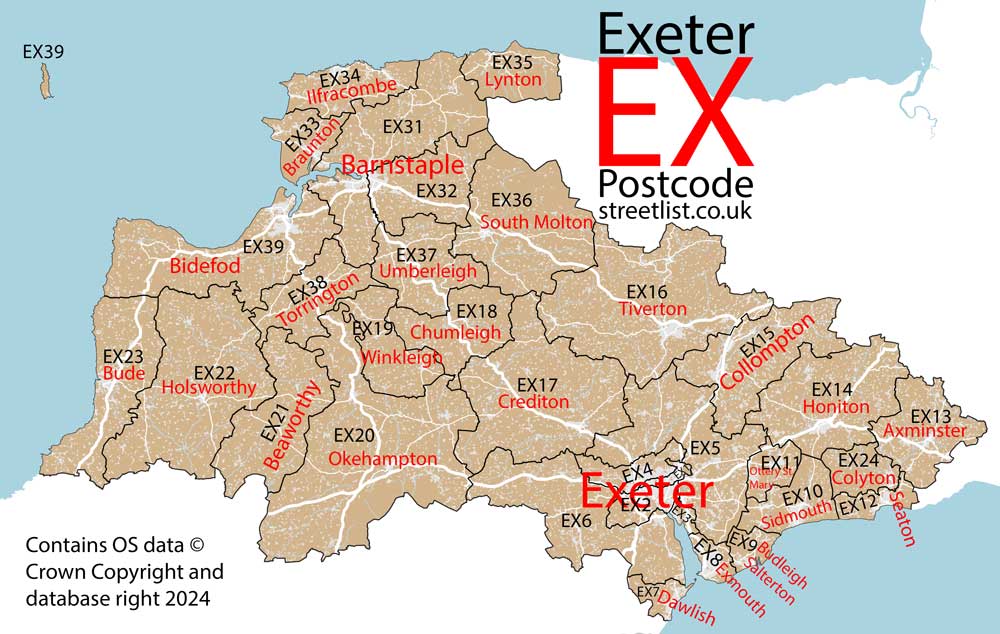
Post Towns and Postcode Districts for the EX Postcode
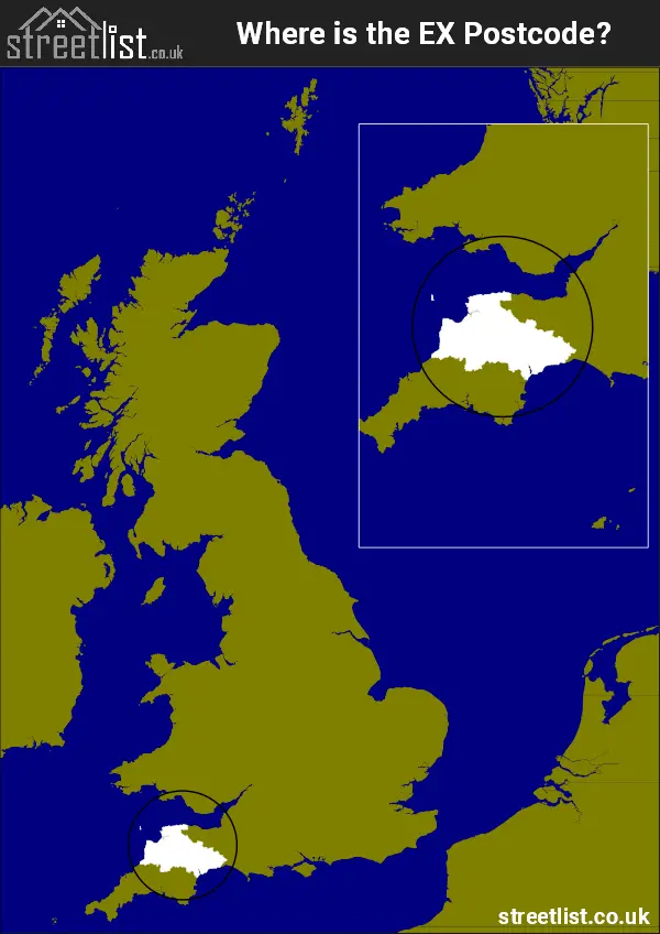
Where is the EX Postcode Area?
The EX Exeter Postcode is in the South West of England. The postal area borders the following neighbouring postal areas: PL - Plymouth, TA - Taunton, DT - Dorchester and TQ - Torquay, It also borders Barnstaple Bay, Exe Estuary, The English Channel, The Celtic Sea and The Bristol Channel.
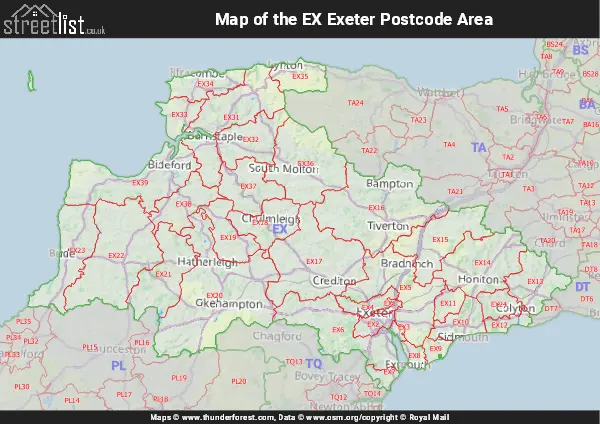
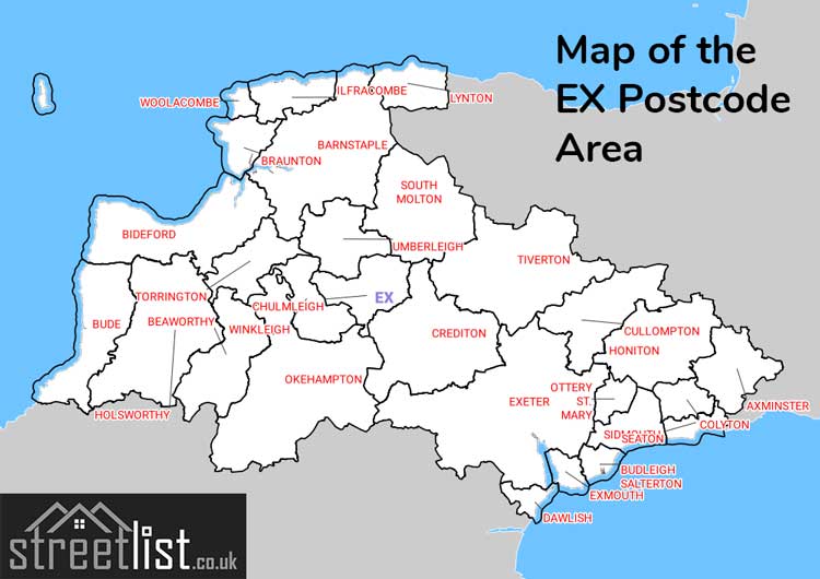
Map of the EX Exeter Postcode Area
Explore the EX Exeter postcode area by using our interactive map.
Postcode Districts within the EX Exeter Postcode Area
There are 33 postcode districts within the Exeter postcode area
A map showing the boundary of in relation to other areas
There are 25 towns within the Exeter postcode area.
| Unit | Area² |
|---|---|
| Hectares | 4,780,391² |
| Miles | 18,457² |
| Feet | 514,556,506,849² |
| Kilometres | 47,804² |
Postal Delivery Offices serving the EX Exeter Postcode Area
- Axminster Delivery Office
- Barnstaple Delivery Office
- Beaworthy Scale Payment Delivery Office
- Bideford Delivery Office
- Bradninch Scale Payment Delivery Office
- Broadclyst Scale Payment Delivery Office
- Bude Delivery Office
- Budleigh Salterton Delivery Office
- Cheriton Bishop Scale Payment Delivery Office
- Chittlehampton Scale Payment Delivery Office
- Christow Scale Payment Delivery Office
- Chulmleigh Scale Payment Delivery Office
- Clyst Honiton Scale Payment Delivery Office
- Combe Martin Scale Payment Delivery Office
- Crediton Delivery Office
- Cullompton Delivery Office
- Dawlish Delivery Office
- Drewsteignton Scale Payment Delivery Office
- Exeter Delivery Office
- Exeter Rurals
- Exminster Scale Payment Delivery Office
- Exmouth Delivery Office
- Hartland Scale Payment Delivery Office
- Hatherleigh Scale Payment Delivery Office
- Hemyock Scale Payment Delivery Office
- Holsworthy Delivery Office
- Honiton Delivery Office
- Ilfracombe Delivery Office
- Kenton Scale Payment Delivery Office
- Landkey Scale Payment Delivery Office
- Lympstone Scale Payment Delivery Office
- Lynton Scale Payment Delivery Office
- Newton St Cyres Scale Payment Delivery Office
- North Tawton Scale Payment Delivery Office
- Okehampton Delivery Office
- Ottery St Mary Scale Payment Delivery Office
- Parracombe Scale Payment Delivery Office
- Seaton Delivery Office
- Sidmouth Delivery Office
- Silverton Scale Payment Delivery Office
- South Molton Delivery Office
- Stoke Canon Scale Payment Delivery Office
- Swimbridge Scale Payment Delivery Office
- Tedburn St. Mary Scale Payment Delivery Office
- Tiverton Delivery Office
- Torrington Delivery Office
- Umberleigh Scale Payment Delivery Office
- Whimple Scale Payment Delivery Office
- Winkleigh Scale Payment Delivery Office
- Woodbury Scale Payment Delivery Office
Councils with Postcodes in EX
Towns and Villages within the EX Exeter Postcode Area
- Abbotsham - village
- Alfington - village
- All Saints - village
- Appledore - village
- Ash Thomas - village
- Ashford - village
- Ashill - village
- Ashreigney - village
- Ashwater - village
- Awliscombe - village
- Axminster - town
- Axmouth - village
- Aylesbeare - village
- Bampton - village
- Barbrook - village
- Barnstaple - town
- Beaford - village
- Beer - village
- Belstone - village
- Belstone Corner - village
- Berrynarbor - village
- Bickington - village
- Bickleigh - village
- Bideford - town
- Bishop's Nympton - village
- Bishop's Tawton - village
- Black Dog - village
- Black Torrington - village
- Blackborough - village
- Bolham - village
- Bow - village
- Bowd - village
- Bradninch - village
- Bradworthy - village
- Brampford Speke - village
- Branscombe - village
- Bratton Clovelly - village
- Bratton Fleming - village
- Braunton - village
- Brayford - village
- Bridestowe - village
- Bridford - village
- Bridgerule - village
- Broadclyst - village
- Broadhembury - village
- Buck's Cross - village
- Buckerell - village
- Buckland Brewer - village
- Bude - town
- Budleigh Salterton - town
- Burrington - village
- Butterleigh - village
- Chambercombe - village
- Chardstock - village
- Chawleigh - village
- Cheriton Bishop - village
- Cheriton Fitzpaine - village
- Chilsworthy - village
- Chittlehamholt - village
- Chittlehampton - village
- Chivenor - village
- Christow - village
- Chulmleigh - village
- Clawton - village
- Clovelly - village
- Clyst Honiton - village
- Clyst Hydon - village
- Clyst St George - village
- Clyst St Lawrence - village
- Clyst St Mary - village
- Cockwood - village
- Colaton Raleigh - village
- Coldridge - village
- Colebrooke - village
- Coleford - village
- Colyford - village
- Colyton - town
- Combe Martin - village
- Combe Raleigh - village
- Copplestone - village
- Cove - village
- Cowley - village
- Crackington Haven - village
- Cranbrook - village
- Crediton - town
- Crockernwell - village
- Croyde - village
- Cullompton - town
- Culmstock - village
- Dalwood - village
- Dawlish - town
- Dawlish Warren - village
- Derril - village
- Doddiscombsleigh - village
- Dolton - village
- Down St Mary - village
- Drewsteignton - village
- Dunchideock - village
- Dunkeswell - village
- Dunsford - village
- East Budleigh - village
- Ebford - village
- Exbourne - village
- Exeter - city
- Exminster - village
- Exmouth - town
- Exton - village
- Fairy Cross - village
- Feniton - village
- Fenny Bridges - village
- Folly Gate - village
- Fordton - village
- Fremington - village
- Frithelstock Stone - village
- Georgeham - village
- Germansweek - village
- Gittisham - village
- Goodleigh - village
- Great Fossend - village
- Great Torrington - town
- Grimscott - village
- Halberton - village
- Halwill Junction - village
- Harpford - village
- Hartland - village
- Hatherleigh - village
- Hawkchurch - village
- Heanton Punchardon - village
- Hele - village
- Hele - village
- Hemyock - village
- High Bickington - village
- Highampton - village
- Higher Clovelly - village
- Higher Crackington - village
- Holcombe - village
- Holsworthy - town
- Holsworthy Beacon - village
- Honiton - town
- Horns Cross - village
- Horwood - village
- Huntsham - village
- Iddesleigh - village
- Ide - village
- Ilfracombe - town
- Instow - village
- Jacobstow - village
- Jacobstowe - village
- Kenn - village
- Kennford - village
- Kentisbeare - village
- Kenton - village
- Kerswell - village
- Kilkhampton - village
- Kilmington - village
- Kings Nympton - village
- Knowle - village
- Knowle - village
- Landkey - village
- Langtree - village
- Lapford - village
- Lewdown - village
- Little Torrington - village
- Longdown - village
- Lower Lovacott - village
- Lydford - village
- Lympstone - village
- Lynmouth - village
- Lynstone - village
- Lynton - town
- Marhamchurch - village
- Membury - village
- Merton - village
- Metcombe - village
- Middle Crackington - village
- Millhayes - village
- Milton Damerel - village
- Molland - village
- Monkleigh - village
- Monkokehampton - village
- Monkton - village
- Morchard Bishop - village
- Morchard Road - village
- Morebath - village
- Mortehoe - village
- Musbury - village
- Nadderwater - village
- Newbuildings - village
- Newton Poppleford - village
- Newton St Cyres - village
- Newton Tracey - village
- Nomansland - village
- Norman's Green - village
- North Molton - village
- North Tawton - town
- Northam - town
- Northleigh - village
- Northlew - village
- Nymet Rowland - village
- Oakford - village
- Offwell - village
- Okehampton - town
- Otterton - village
- Ottery St Mary - town
- Parkham - village
- Parracombe - village
- Pathfinder Village - village
- Payhembury - village
- Pennymoor - village
- Petrockstowe - village
- Plymtree - village
- Poltimore - village
- Poughill - village
- Poughill - village
- Poundstock - village
- Prixford - village
- Puddington - village
- Pyworthy - village
- Rackenford - village
- Rawridge - village
- Raymond's Hill - village
- Rewe - village
- Riddlecombe - village
- Roborough - village
- Rockbeare - village
- Rose Ash - village
- Sampford Courtenay - village
- Sampford Peverell - village
- Sandford - village
- Saunton - village
- Seaton - town
- Shebbear - village
- Sheepwash - village
- Sheldon - village
- Shillingford - village
- Shillingford Abbot - village
- Shillingford St George - village
- Shirwell Cross - village
- Shobrooke - village
- Shop - village
- Shute - village
- Sidbury - village
- Sidmouth - town
- Silverton - village
- Smallridge - village
- Sourton - village
- South Molton - town
- South Tawton - village
- South Zeal - village
- Southleigh - village
- Sowton - village
- Spreyton - village
- St Giles in the Wood - village
- St John's Chapel - village
- Starcross - village
- Stibb Cross - village
- Sticklepath - village
- Stockland - village
- Stoke Canon - village
- Stoneyford - village
- Stoodleigh - village
- Stowford - village
- Stratton - town
- Street - village
- Sutcombe - village
- Taddiport - village
- Talaton - village
- Taleford - village
- Tedburn St Mary - village
- Thorverton - village
- Three Horse Shoes - village
- Throwleigh - village
- Tipton St John - village
- Tiverton - town
- Topsham - town
- Tytherleigh - village
- Uffculme - village
- Umberleigh - village
- Upottery - village
- Upton Pyne - village
- Wainhouse Corner - village
- Weare Giffard - village
- Week St Mary - village
- Wembworthy - village
- West Buckland - village
- West Clyst - village
- West Down - village
- West Hill - village
- Westacott - village
- Westleigh - village
- Westleigh - village
- Weston - village
- Westward Ho! - village
- Whiddon Down - village
- Whimple - village
- Whitestone - village
- Whitford - village
- Whitstone - village
- Widemouth Bay - village
- Willand - village
- Wilmington - village
- Winkleigh - village
- Witheridge - village
- Withleigh - village
- Woodbury - village
- Woodbury Salterton - village
- Woodford - village
- Woolacombe - village
- Woolfardisworthy - village
- Wrafton - village
- Yarcombe - village
- Yarnscombe - village
- Yelland - village
- Yeoford - village
- Yettington - village
- Yondercott - village
- Zeal Monachorum - village