The PL26 postcode district is a postal district located in the PL Plymouth postcode area with a population of 28,257 residents according to the 2021 England and Wales Census.
The area of the PL26 postcode district is 65.49 square miles which is 169.63 square kilometres or 41,915.40 acres.
Currently, the PL26 district has about 859 postcode units spread across 3 geographic postcode sectors.
Given that each sector allows for 400 unique postcode combinations, the district has a capacity of 1,200 postcodes. With 859 postcodes already in use, this leaves 341 units available.
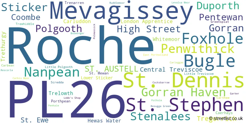
The largest settlement in the PL26 postal code is Roche followed by Bugle, and Mevagissey.
The postcode area has a boundary with The English Channel.
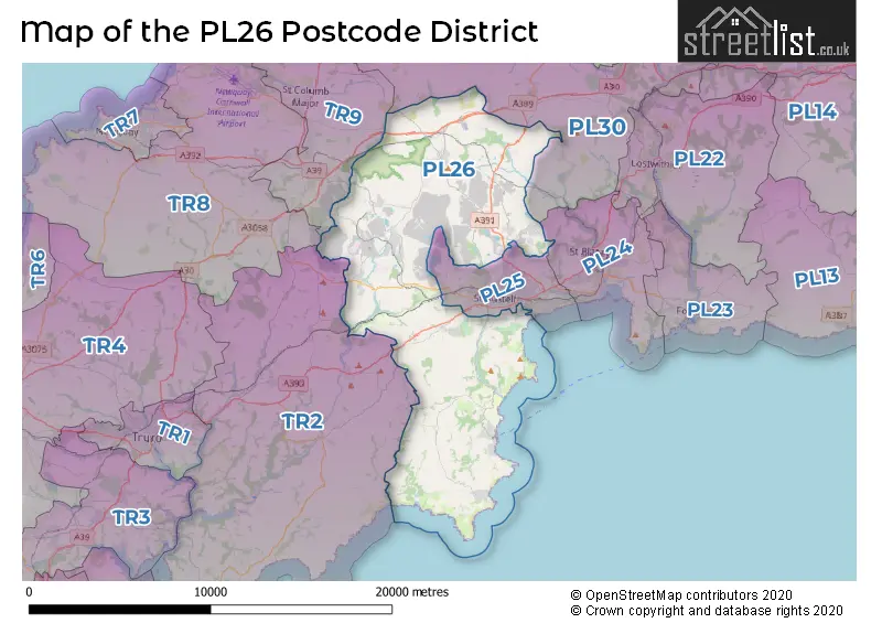
The PL26 Postcode shares a border with TR2 (Probus, Portscatho, St. Mawes), TR9 (ST. COLUMB, Indian Queens, Fraddon), PL25 (ST. AUSTELL, Carlyon Bay, Trewoon), PL24 (PAR, St. Blazey, Tywardreath) and PL30 (St. Breward, Lanivet, St. Teath).
The primary settlement in the PL26 postcode district is St. Austell, which is located in the county of Cornwall in England. Other significant settlements in this postcode district include Boswinger, Caerhays, Duporth, East Portholland, Gorran, Gorran Haven, Levalsa Meor, Lobb's Shop, Mevagissey, Pentewan, Polmassick, Porthpean, St. Ewe, Trenarren, Central Treviscoe, Coombe, Foxhole, Hewas Water, High Street, Little Polgooth, Little Treviscoe, London Apprentice, Lower Sticker, Nanpean, Polgooth, Pothole, St. Mewan, St. Stephen, Sticker, Tregorrick, Trelowth, Trewhiddle, and Whitemoor. The most significant post town in this postcode district is St. Austell.
For the district PL26, we have data on 3 postcode sectors. Here's a breakdown: The sector PL26 6, covers Mevagissey and Gorran Haven and Duporth in Cornwall. The sector PL26 7, covers St. Stephen and Foxhole and Nanpean in Cornwall. The sector PL26 8, covers Roche and St. Dennis and Bugle in Cornwall.

Map of the PL26 Postcode District
Explore the PL26 postcode district by using our free interactive map.
When it comes to local government, postal geography often disregards political borders. However, for a breakdown in the PL26 District: the district mostly encompasses the Cornwall area with a total of 880 postcodes.
Recent House Sales in PL26
| Date | Price | Address |
|---|---|---|
| 30/10/2023 | £340,000 | Myrtle Court, Mevagissey, St Austell, PL26 6UT |
| 12/10/2023 | £36,000 | Currian Road, Nanpean, St Austell, PL26 7YD |
| 05/10/2023 | £190,000 | Carloggas, St Austell, PL26 8YS |
| 04/10/2023 | £270,000 | Yeomans Court, Roche, St Austell, PL26 8JS |
| 04/10/2023 | £555,000 | Portmellon Park, Mevagissey, St Austell, PL26 6XD |
| 02/10/2023 | £370,000 | Bowling Green, St Austell, PL26 8RN |
| 21/09/2023 | £135,000 | Tregoney Hill, Mevagissey, St Austell, PL26 6RP |
| 13/09/2023 | £139,950 | Tregoney Hill, Mevagissey, St Austell, PL26 6RR |
| 11/09/2023 | £215,000 | Trelowth Road, Polgooth, St Austell, PL26 7BG |
| 11/09/2023 | £160,000 | Tynance Court, St Dennis, St Austell, PL26 8FL |
Weather Forecast for PL26
Press Button to Show Forecast for Lost Gardens Of Heligan
| Time Period | Icon | Description | Temperature | Rain Probability | Wind |
|---|---|---|---|---|---|
| 06:00 to 09:00 | Cloudy | 7.0°C (feels like 5.0°C) | 7.00% | NE 7 mph | |
| 09:00 to 12:00 | Light rain shower (day) | 9.0°C (feels like 7.0°C) | 55.00% | E 9 mph | |
| 12:00 to 15:00 | Cloudy | 11.0°C (feels like 9.0°C) | 7.00% | ESE 7 mph | |
| 15:00 to 18:00 | Light rain shower (day) | 11.0°C (feels like 9.0°C) | 45.00% | NNE 7 mph | |
| 18:00 to 21:00 | Cloudy | 10.0°C (feels like 8.0°C) | 14.00% | NNE 11 mph | |
| 21:00 to 00:00 | Partly cloudy (night) | 8.0°C (feels like 5.0°C) | 3.00% | NNE 11 mph |
Press Button to Show Forecast for Lost Gardens Of Heligan
| Time Period | Icon | Description | Temperature | Rain Probability | Wind |
|---|---|---|---|---|---|
| 00:00 to 03:00 | Cloudy | 7.0°C (feels like 4.0°C) | 9.00% | N 9 mph | |
| 03:00 to 06:00 | Cloudy | 7.0°C (feels like 4.0°C) | 50.00% | N 11 mph | |
| 06:00 to 09:00 | Sunny day | 7.0°C (feels like 4.0°C) | 4.00% | NNW 9 mph | |
| 09:00 to 12:00 | Partly cloudy (day) | 10.0°C (feels like 7.0°C) | 3.00% | NNW 13 mph | |
| 12:00 to 15:00 | Cloudy | 11.0°C (feels like 8.0°C) | 8.00% | NW 11 mph | |
| 15:00 to 18:00 | Partly cloudy (day) | 11.0°C (feels like 8.0°C) | 1.00% | WNW 11 mph | |
| 18:00 to 21:00 | Partly cloudy (day) | 10.0°C (feels like 8.0°C) | 1.00% | W 9 mph | |
| 21:00 to 00:00 | Clear night | 6.0°C (feels like 4.0°C) | 1.00% | WSW 7 mph |
Press Button to Show Forecast for Lost Gardens Of Heligan
| Time Period | Icon | Description | Temperature | Rain Probability | Wind |
|---|---|---|---|---|---|
| 00:00 to 03:00 | Cloudy | 6.0°C (feels like 4.0°C) | 4.00% | SSW 9 mph | |
| 03:00 to 06:00 | Cloudy | 7.0°C (feels like 4.0°C) | 5.00% | SSW 11 mph | |
| 06:00 to 09:00 | Cloudy | 9.0°C (feels like 6.0°C) | 6.00% | S 13 mph | |
| 09:00 to 12:00 | Cloudy | 11.0°C (feels like 8.0°C) | 9.00% | S 18 mph | |
| 12:00 to 15:00 | Partly cloudy (day) | 12.0°C (feels like 8.0°C) | 9.00% | S 20 mph | |
| 15:00 to 18:00 | Cloudy | 12.0°C (feels like 8.0°C) | 14.00% | S 20 mph | |
| 18:00 to 21:00 | Light rain | 11.0°C (feels like 8.0°C) | 44.00% | S 18 mph | |
| 21:00 to 00:00 | Light rain | 11.0°C (feels like 7.0°C) | 51.00% | S 18 mph |
Press Button to Show Forecast for Lost Gardens Of Heligan
| Time Period | Icon | Description | Temperature | Rain Probability | Wind |
|---|---|---|---|---|---|
| 00:00 to 03:00 | Heavy rain | 10.0°C (feels like 7.0°C) | 70.00% | SSE 20 mph | |
| 03:00 to 06:00 | Heavy rain | 10.0°C (feels like 7.0°C) | 87.00% | SSE 18 mph | |
| 06:00 to 09:00 | Heavy rain | 10.0°C (feels like 7.0°C) | 80.00% | SSE 18 mph | |
| 09:00 to 12:00 | Heavy rain | 11.0°C (feels like 7.0°C) | 69.00% | SSE 18 mph | |
| 12:00 to 15:00 | Heavy rain | 11.0°C (feels like 8.0°C) | 83.00% | SSE 18 mph | |
| 15:00 to 18:00 | Heavy rain | 11.0°C (feels like 8.0°C) | 80.00% | SSE 16 mph | |
| 18:00 to 21:00 | Light rain shower (day) | 11.0°C (feels like 8.0°C) | 42.00% | SSE 13 mph | |
| 21:00 to 00:00 | Cloudy | 10.0°C (feels like 8.0°C) | 12.00% | SE 11 mph |
Where is the PL26 Postcode District?
The postcode district PL26 is located in St. Austell, a district town. It is nearby the towns of Par to the East (5.78 miles), St. Columb to the North West (7.49 miles), Lostwithiel to the North East (9.37 miles), Wadebridge to the North (12.10 miles), Truro to the South West (13.38 miles), and Perranporth to the West (14.15 miles). Additionally, the distance from PL26 to the center of London is 220.52 miles.
The district is within the post town of ST. AUSTELL.
The sector has postcodes within the nation of England.
The PL26 Postcode District is in the Cornwall and Isles of Scilly region of Cornwall and Isles of Scilly within the South West (England).
| Postcode Sector | Delivery Office |
|---|---|
| PL26 6 | St. Austell Delivery Office |
| PL26 7 | St. Austell Delivery Office |
| PL26 8 | St. Austell Delivery Office |
| P | L | 2 | 6 | - | X | X | X |
| P | L | 2 | 6 | Space | Numeric | Letter | Letter |
Tourist Attractions within the Postcode Area
We found 3 visitor attractions within the PL26 postcode area
| Lost Gardens of Heligan |
|---|
| Gardens |
| Garden |
| View Lost Gardens of Heligan on Google Maps |
| The China Clay Museum |
| Visitor Centres |
| Heritage / Visitor Centre |
| View The China Clay Museum on Google Maps |
| Wheal Martyn China Clay Country Park |
| Visitor Centres |
| Heritage / Visitor Centre |
| View Wheal Martyn China Clay Country Park on Google Maps |
Current Monthly Rental Prices
| # Bedrooms | Min Price | Max Price | Avg Price |
|---|---|---|---|
| 1 | £695 | £695 | £695 |
| 2 | £925 | £925 | £925 |
| 3 | £750 | £1,500 | £1,146 |
Current House Prices
| # Bedrooms | Min Price | Max Price | Avg Price |
|---|---|---|---|
| £40,000 | £2,000,000 | £448,529 | |
| 1 | £45,000 | £279,950 | £149,989 |
| 2 | £54,950 | £499,950 | £243,551 |
| 3 | £70,000 | £1,795,000 | £351,848 |
| 4 | £135,000 | £1,750,000 | £561,478 |
| 5 | £300,000 | £3,750,000 | £789,333 |
| 6 | £600,000 | £900,000 | £780,000 |
| 7 | £1,500,000 | £1,950,000 | £1,725,000 |
Estate Agents who Operate in the PL26 District
| Logo | Name | Brand Name | Address | Contact Number | Total Properties |
|---|---|---|---|---|---|
 | Mevagissey | Hunkin Homes | The Mac, Valley Road, Mevagissey Cornwall PL26 6SA | 01726 219673 | 34 |
 | St Austell | May Whetter & Grose | Piran House, 11 Fore Street, St. Austell, PL25 5PX | 01726 219607 | 33 |
 | St. Austell | Stratton Creber | 47 Aylmer Square St. Austell PL25 5LJ | 01726 213640 | 27 |
 | St. Austell | Millerson | 5/6 Market Street, St. Austell, PL25 4BB | 01726 219660 | 21 |
 | St Austell | Liddicoat & Company | 6 Vicarage Hill, St. Austell, PL25 5PL | 01726 219670 | 20 |
- Bilberry
- Bugle
- Carpalla
- Coombe
- Duporth
- Foxhole
- Gorran Haven
- Goverseth
- High Street
- Hornick
- Lanivet
- Lanjeth
- Little Polgooth
- Mevagissey
- Nanpean
- Pentewan
- Penwithick
- Polgooth
- Roche
- Scredda
- St Austell
- St Dennis
- St Ewe
- St Stephen
- Stenalees
- Sticker
- Terras
- Tregavarras
- Tregorrick
- Trelowth
- Trethurgy
- Treviscoe
- Trewoon
- Trezaise
- Victoria
- Whitemoor
| Type of Property | 2018 Average | 2018 Sales | 2017 Average | 2017 Sales | 2016 Average | 2016 Sales | 2015 Average | 2015 Sales |
|---|---|---|---|---|---|---|---|---|
| Detached | £309,528 | 184 | £296,468 | 193 | £263,807 | 222 | £266,439 | 203 |
| Semi-Detached | £178,061 | 120 | £161,090 | 127 | £162,603 | 107 | £155,980 | 105 |
| Terraced | £148,391 | 119 | £150,764 | 129 | £150,037 | 120 | £157,762 | 125 |
| Flats | £139,560 | 30 | £155,795 | 22 | £157,510 | 20 | £145,885 | 68 |