The PL29 postcode district is a postal district located in the PL Plymouth postcode area with a population of 926 residents according to the 2021 England and Wales Census.
The area of the PL29 postcode district is 7.32 square miles which is 18.95 square kilometres or 4,682.34 acres.
Currently, the PL29 district has about 58 postcode units spread across 1 geographic postcode sectors.
Given that each sector allows for 400 unique postcode combinations, the district has a capacity of 400 postcodes. With 58 postcodes already in use, this leaves 342 units available.
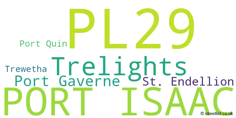
The largest settlement in the PL29 postal code is PORT ISAAC followed by Trelights, and Port Gaverne.
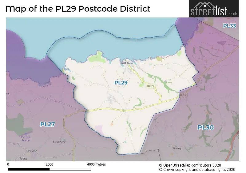
The postcode area has a boundary with Celtic Sea.
The PL29 Postcode shares a border with PL27 (WADEBRIDGE, St. Minver, Rock) and PL30 (St. Breward, Lanivet, St. Teath).
The primary settlement in the PL29 postcode district is Port Isaac, located in Cornwall, England. Other significant settlements in the district include Port Gaverne, Port Quin, St. Endellion, Trelights, and Trewetha.
For the district PL29, we have data on 1 postcode sectors. Here's a breakdown: The sector PL29 3, covers Port Isaac and Trelights in Cornwall.
PL29 Postcode Sectors

Map of the PL29 Postcode District
Explore the PL29 postcode district by using our free interactive map.
When it comes to local government, postal geography often disregards political borders. However, for a breakdown in the PL29 District: the district mostly encompasses the Cornwall area with a total of 58 postcodes.
Recent House Sales in PL29
| Date | Price | Address |
|---|---|---|
| 25/09/2023 | £350,000 | Fore Street, Port Isaac, PL29 3RD |
| 18/08/2023 | £510,000 | Lundy Road, Port Isaac, PL29 3RR |
| 27/07/2023 | £340,000 | Fore Street, Port Isaac, PL29 3RB |
| 20/07/2023 | £545,000 | Church Hill, Port Isaac, PL29 3RQ |
| 02/06/2023 | £700,000 | New Road, Port Isaac, PL29 3SD |
| 15/05/2023 | £450,000 | New Road, Port Isaac, PL29 3SB |
| 12/05/2023 | £3,530,000 | Port Isaac, PL29 3TA |
| 10/03/2023 | £435,000 | Fore Street, Port Isaac, PL29 3RB |
| 02/03/2023 | £735,000 | Fore Street, Port Isaac, PL29 3RB |
| 02/03/2023 | £535,000 | Dolphin Street, Port Isaac, PL29 3RJ |
Weather Forecast for PL29
Press Button to Show Forecast for Long Cross Victorian Gardens
| Time Period | Icon | Description | Temperature | Rain Probability | Wind |
|---|---|---|---|---|---|
| 18:00 to 21:00 | Heavy rain shower (day) | 8.0°C (feels like 7.0°C) | 73.00% | E 7 mph | |
| 21:00 to 00:00 | Light rain | 7.0°C (feels like 5.0°C) | 54.00% | E 7 mph |
Press Button to Show Forecast for Long Cross Victorian Gardens
| Time Period | Icon | Description | Temperature | Rain Probability | Wind |
|---|---|---|---|---|---|
| 00:00 to 03:00 | Overcast | 7.0°C (feels like 5.0°C) | 12.00% | ESE 7 mph | |
| 03:00 to 06:00 | Cloudy | 6.0°C (feels like 4.0°C) | 7.00% | E 7 mph | |
| 06:00 to 09:00 | Cloudy | 6.0°C (feels like 4.0°C) | 6.00% | E 7 mph | |
| 09:00 to 12:00 | Partly cloudy (day) | 9.0°C (feels like 7.0°C) | 37.00% | ENE 9 mph | |
| 12:00 to 15:00 | Light rain shower (day) | 10.0°C (feels like 8.0°C) | 39.00% | N 11 mph | |
| 15:00 to 18:00 | Light rain shower (day) | 10.0°C (feels like 8.0°C) | 40.00% | N 11 mph | |
| 18:00 to 21:00 | Cloudy | 10.0°C (feels like 7.0°C) | 35.00% | NNE 16 mph | |
| 21:00 to 00:00 | Cloudy | 8.0°C (feels like 4.0°C) | 33.00% | NNE 16 mph |
Press Button to Show Forecast for Long Cross Victorian Gardens
| Time Period | Icon | Description | Temperature | Rain Probability | Wind |
|---|---|---|---|---|---|
| 00:00 to 03:00 | Cloudy | 8.0°C (feels like 4.0°C) | 16.00% | NNE 16 mph | |
| 03:00 to 06:00 | Cloudy | 8.0°C (feels like 4.0°C) | 16.00% | N 16 mph | |
| 06:00 to 09:00 | Partly cloudy (day) | 8.0°C (feels like 4.0°C) | 4.00% | N 16 mph | |
| 09:00 to 12:00 | Cloudy | 9.0°C (feels like 6.0°C) | 8.00% | NNW 13 mph | |
| 12:00 to 15:00 | Light rain shower (day) | 10.0°C (feels like 8.0°C) | 35.00% | NW 11 mph | |
| 15:00 to 18:00 | Partly cloudy (day) | 10.0°C (feels like 8.0°C) | 1.00% | WNW 11 mph | |
| 18:00 to 21:00 | Sunny day | 10.0°C (feels like 7.0°C) | 1.00% | W 11 mph | |
| 21:00 to 00:00 | Partly cloudy (night) | 6.0°C (feels like 4.0°C) | 1.00% | SW 9 mph |
Press Button to Show Forecast for Long Cross Victorian Gardens
| Time Period | Icon | Description | Temperature | Rain Probability | Wind |
|---|---|---|---|---|---|
| 00:00 to 03:00 | Partly cloudy (night) | 6.0°C (feels like 3.0°C) | 1.00% | S 9 mph | |
| 03:00 to 06:00 | Cloudy | 6.0°C (feels like 3.0°C) | 5.00% | S 9 mph | |
| 06:00 to 09:00 | Cloudy | 8.0°C (feels like 5.0°C) | 5.00% | S 11 mph | |
| 09:00 to 12:00 | Cloudy | 11.0°C (feels like 8.0°C) | 8.00% | S 18 mph | |
| 12:00 to 15:00 | Light rain shower (day) | 11.0°C (feels like 8.0°C) | 45.00% | S 20 mph | |
| 15:00 to 18:00 | Cloudy | 12.0°C (feels like 8.0°C) | 14.00% | S 20 mph | |
| 18:00 to 21:00 | Cloudy | 11.0°C (feels like 7.0°C) | 15.00% | S 18 mph | |
| 21:00 to 00:00 | Light rain | 10.0°C (feels like 6.0°C) | 48.00% | SSE 16 mph |
Press Button to Show Forecast for Long Cross Victorian Gardens
| Time Period | Icon | Description | Temperature | Rain Probability | Wind |
|---|---|---|---|---|---|
| 00:00 to 03:00 | Light rain | 10.0°C (feels like 6.0°C) | 50.00% | SSE 18 mph | |
| 03:00 to 06:00 | Heavy rain | 9.0°C (feels like 6.0°C) | 86.00% | SSE 16 mph | |
| 06:00 to 09:00 | Heavy rain | 9.0°C (feels like 6.0°C) | 84.00% | SSE 16 mph | |
| 09:00 to 12:00 | Heavy rain | 10.0°C (feels like 7.0°C) | 69.00% | SSE 16 mph | |
| 12:00 to 15:00 | Heavy rain | 11.0°C (feels like 8.0°C) | 82.00% | SSE 18 mph | |
| 15:00 to 18:00 | Heavy rain | 11.0°C (feels like 9.0°C) | 81.00% | SSE 16 mph | |
| 18:00 to 21:00 | Light rain | 11.0°C (feels like 8.0°C) | 51.00% | SSE 11 mph | |
| 21:00 to 00:00 | Cloudy | 9.0°C (feels like 7.0°C) | 10.00% | SE 9 mph |
Where is the PL29 Postcode District?
The postcode district PL29 is located in the town of Port Isaac. This town is situated in close proximity to nearby towns such as Delabole, which is approximately 4.98 miles away towards the North East, and Wadebridge, which is about 5.94 miles away towards the South West. Additionally, the town of Bodmin is located around 8.74 miles away towards the South East. Furthermore, the postcode district PL29 is approximately 214.53 miles away from the centre of London.
The district is within the post town of PORT ISAAC.
The sector has postcodes within the nation of England.
The PL29 Postcode District is in the Cornwall and Isles of Scilly region of Cornwall and Isles of Scilly within the South West (England).
Postcode Sectors within the PL29 District
| Postcode Sector | Delivery Office |
|---|---|
| PL29 3 | Bodmin Delivery Office |
| PL29 3 | Port Isaac Scale Payment Delivery Office |
| P | L | 2 | 9 | - | X | X | X |
| P | L | 2 | 9 | Space | Numeric | Letter | Letter |
Current Monthly Rental Prices
| # Bedrooms | Min Price | Max Price | Avg Price |
|---|---|---|---|
| 2 | £975 | £975 | £975 |
| 4 | £1,800 | £1,800 | £1,800 |
Current House Prices
| # Bedrooms | Min Price | Max Price | Avg Price |
|---|---|---|---|
| 1 | £280,000 | £280,000 | £280,000 |
| 2 | £280,000 | £650,000 | £441,667 |
| 3 | £395,000 | £735,000 | £519,800 |
| 4 | £695,000 | £1,500,000 | £932,857 |
| 5 | £750,000 | £1,250,000 | £1,000,000 |
| 6 | £870,000 | £1,400,000 | £1,135,000 |
Estate Agents who Operate in the PL29 District
| Logo | Name | Brand Name | Address | Contact Number | Total Properties |
|---|---|---|---|---|---|
 | Rock | John Bray & Partners | Pavilion Building, Rock, Wadebridge, Cornwall, PL27 6JU | 01208 223209 | 14 |
 | Padstow | Cole Rayment & White | 3 Duke Street, Padstow, Cornwall, PL28 8AB | 01637 801060 | 3 |
 | Truro | Savills | 73 Lemon Street, Truro, TR1 2PN | 01872 303974 | 3 |
 | Wadebridge | Estuary Estates | Trebetherick House, Trebetherick, Wadebridge, PL27 6SB | 01208 228725 | 2 |
 | Wadebridge | Miller Lettings | 30 Molesworth Street, Wadebridge, PL27 7DP | 01208 228736 | 1 |
| Type of Property | 2018 Average | 2018 Sales | 2017 Average | 2017 Sales | 2016 Average | 2016 Sales | 2015 Average | 2015 Sales |
|---|---|---|---|---|---|---|---|---|
| Detached | £498,000 | 10 | £406,063 | 24 | £375,833 | 12 | £464,607 | 15 |
| Semi-Detached | £925,000 | 1 | £255,000 | 3 | £353,750 | 6 | £334,500 | 10 |
| Terraced | £360,375 | 16 | £328,167 | 9 | £304,056 | 9 | £342,831 | 13 |
| Flats | £288,500 | 2 | £476,667 | 3 | £292,500 | 2 | £195,933 | 3 |