The PL17 postcode district is a postal district located in the PL Plymouth postcode area with a population of 10,307 residents according to the 2021 England and Wales Census.
The area of the PL17 postcode district is 36.20 square miles which is 93.75 square kilometres or 23,165.30 acres.
Currently, the PL17 district has about 415 postcode units spread across 2 geographic postcode sectors.
Given that each sector allows for 400 unique postcode combinations, the district has a capacity of 800 postcodes. With 415 postcodes already in use, this leaves 385 units available.
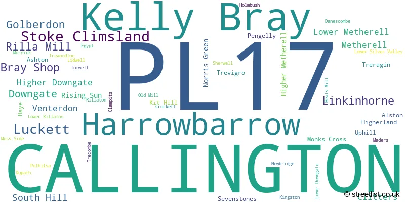
The largest settlement in the PL17 postal code is CALLINGTON followed by Kelly Bray, and Harrowbarrow.
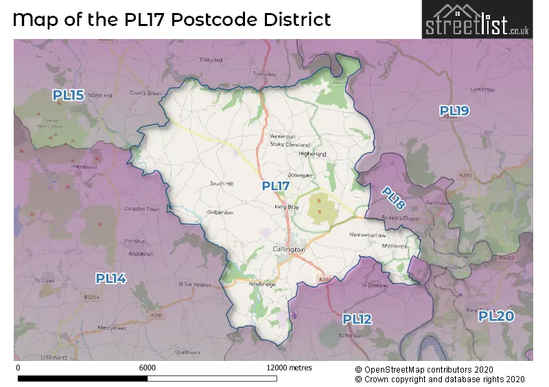
The PL17 Postcode shares a border with PL15 (LAUNCESTON, St. Giles-on-the-Heath, Altarnun), PL18 (GUNNISLAKE, CALSTOCK, St. Anns Chapel), PL19 (TAVISTOCK, Mary Tavy, Whitchurch), PL12 (SALTASH, Latchbrook, Landrake) and PL14 (LISKEARD, Pensilva, Dobwalls).
In the PL17 postcode district in Cornwall, the primary settlement with the highest count is Callington. Other significant settlements in this district include Golberdon, Linkinhorne, Rilla Mill, South Hill, and Trevigro. The most significant post town in this district is Callington. Cornwall is the county in which these settlements are located.
For the district PL17, we have data on 3 postcode sectors. Here's a breakdown: The sector PL17 0 is non-geographic. It's often designated for PO Boxes, large organisations, or special services. The sector PL17 7, covers Callington in Cornwall. The sector PL17 8, covers Callington and Kelly Bray and Harrowbarrow in Cornwall.

Map of the PL17 Postcode District
Explore the PL17 postcode district by using our free interactive map.
When it comes to local government, postal geography often disregards political borders. However, for a breakdown in the PL17 District: the district mostly encompasses the Cornwall area with a total of 422 postcodes.
Recent House Sales in PL17
| Date | Price | Address |
|---|---|---|
| 21/10/2023 | £399,995 | Glebelands, Callington, PL17 7PP |
| 02/10/2023 | £120,000 | Liskeard Road, Callington, PL17 7JD |
| 29/09/2023 | £330,000 | Chapel Meadow, Callington, PL17 7FX |
| 29/09/2023 | £280,000 | Highbury, Rilla Mill, Callington, PL17 7PH |
| 29/09/2023 | £230,000 | Tavistock Road, Callington, PL17 7BG |
| 26/09/2023 | £315,000 | Barsbuttel Road, Callington, PL17 7FP |
| 19/09/2023 | £440,000 | Lidwell, Callington, PL17 8LJ |
| 14/09/2023 | £174,000 | Amble Road, Callington, PL17 7QE |
| 22/08/2023 | £550,000 | Middle Hampt, Callington, PL17 8NR |
| 17/08/2023 | £185,000 | Duchy Cottages, Stoke Climsland, Callington, PL17 8PA |
Weather Forecast for PL17
Press Button to Show Forecast for Callington
| Time Period | Icon | Description | Temperature | Rain Probability | Wind |
|---|---|---|---|---|---|
| 21:00 to 00:00 | Light rain | 7.0°C (feels like 5.0°C) | 53.00% | ENE 7 mph |
Press Button to Show Forecast for Callington
| Time Period | Icon | Description | Temperature | Rain Probability | Wind |
|---|---|---|---|---|---|
| 00:00 to 03:00 | Cloudy | 6.0°C (feels like 5.0°C) | 10.00% | NNE 4 mph | |
| 03:00 to 06:00 | Cloudy | 6.0°C (feels like 4.0°C) | 10.00% | NNE 4 mph | |
| 06:00 to 09:00 | Cloudy | 6.0°C (feels like 4.0°C) | 7.00% | NE 4 mph | |
| 09:00 to 12:00 | Cloudy | 9.0°C (feels like 7.0°C) | 47.00% | ENE 7 mph | |
| 12:00 to 15:00 | Light rain shower (day) | 11.0°C (feels like 9.0°C) | 38.00% | NE 7 mph | |
| 15:00 to 18:00 | Heavy rain shower (day) | 11.0°C (feels like 9.0°C) | 60.00% | N 9 mph | |
| 18:00 to 21:00 | Cloudy | 9.0°C (feels like 6.0°C) | 8.00% | NNE 11 mph | |
| 21:00 to 00:00 | Cloudy | 7.0°C (feels like 4.0°C) | 13.00% | N 11 mph |
Press Button to Show Forecast for Callington
| Time Period | Icon | Description | Temperature | Rain Probability | Wind |
|---|---|---|---|---|---|
| 00:00 to 03:00 | Overcast | 7.0°C (feels like 3.0°C) | 13.00% | N 11 mph | |
| 03:00 to 06:00 | Cloudy | 6.0°C (feels like 3.0°C) | 10.00% | N 11 mph | |
| 06:00 to 09:00 | Partly cloudy (day) | 6.0°C (feels like 3.0°C) | 5.00% | NNW 11 mph | |
| 09:00 to 12:00 | Partly cloudy (day) | 9.0°C (feels like 6.0°C) | 4.00% | NNW 11 mph | |
| 12:00 to 15:00 | Cloudy | 11.0°C (feels like 8.0°C) | 8.00% | NW 11 mph | |
| 15:00 to 18:00 | Cloudy | 11.0°C (feels like 9.0°C) | 5.00% | WNW 11 mph | |
| 18:00 to 21:00 | Sunny day | 10.0°C (feels like 8.0°C) | 1.00% | WNW 9 mph | |
| 21:00 to 00:00 | Clear night | 5.0°C (feels like 3.0°C) | 0.00% | WSW 4 mph |
Press Button to Show Forecast for Callington
| Time Period | Icon | Description | Temperature | Rain Probability | Wind |
|---|---|---|---|---|---|
| 00:00 to 03:00 | Clear night | 5.0°C (feels like 3.0°C) | 1.00% | SSW 7 mph | |
| 03:00 to 06:00 | Cloudy | 6.0°C (feels like 3.0°C) | 5.00% | S 7 mph | |
| 06:00 to 09:00 | Cloudy | 8.0°C (feels like 5.0°C) | 5.00% | S 9 mph | |
| 09:00 to 12:00 | Cloudy | 10.0°C (feels like 7.0°C) | 9.00% | S 16 mph | |
| 12:00 to 15:00 | Cloudy | 11.0°C (feels like 8.0°C) | 12.00% | S 18 mph | |
| 15:00 to 18:00 | Light rain shower (day) | 11.0°C (feels like 8.0°C) | 32.00% | S 18 mph | |
| 18:00 to 21:00 | Cloudy | 10.0°C (feels like 7.0°C) | 15.00% | S 16 mph | |
| 21:00 to 00:00 | Light rain | 10.0°C (feels like 7.0°C) | 45.00% | SSE 16 mph |
Press Button to Show Forecast for Callington
| Time Period | Icon | Description | Temperature | Rain Probability | Wind |
|---|---|---|---|---|---|
| 00:00 to 03:00 | Light rain | 9.0°C (feels like 6.0°C) | 48.00% | SSE 16 mph | |
| 03:00 to 06:00 | Light rain | 9.0°C (feels like 6.0°C) | 60.00% | SSE 16 mph | |
| 06:00 to 09:00 | Heavy rain | 9.0°C (feels like 6.0°C) | 87.00% | SSE 16 mph | |
| 09:00 to 12:00 | Heavy rain | 10.0°C (feels like 7.0°C) | 72.00% | SSE 16 mph | |
| 12:00 to 15:00 | Heavy rain | 11.0°C (feels like 8.0°C) | 83.00% | SSE 16 mph | |
| 15:00 to 18:00 | Heavy rain | 11.0°C (feels like 8.0°C) | 81.00% | SSE 16 mph | |
| 18:00 to 21:00 | Light rain shower (day) | 10.0°C (feels like 8.0°C) | 42.00% | SSE 11 mph | |
| 21:00 to 00:00 | Cloudy | 8.0°C (feels like 6.0°C) | 11.00% | SE 9 mph |
Where is the PL17 Postcode District?
The postcode district for PL17 is located in the town of Callington. Callington is situated in close proximity to several nearby towns. To the east of Callington is Gunnislake, which is approximately 4.5 miles away. Moving west, the town of Liskeard is around 6.8 miles from Callington. In the north east direction, you will find Lifton, which is approximately 7.2 miles away. Going south, the town of Saltash is located around 7.4 miles from Callington. Finally, in the north west direction, you will encounter Launceston, which is about 8.9 miles away. Moreover, Callington is located at a distance of 195 miles from the center of London.
The district is within the post town of CALLINGTON.
The sector has postcodes within the nation of England.
The PL17 Postcode District is covers the following regions.
- Cornwall and Isles of Scilly - Cornwall and Isles of Scilly - South West (England)
- Devon CC - Devon - South West (England)
| Postcode Sector | Delivery Office |
|---|---|
| PL17 7 | Callington Delivery Office |
| PL17 8 | Callington Delivery Office |
| P | L | 1 | 7 | - | X | X | X |
| P | L | 1 | 7 | Space | Numeric | Letter | Letter |
Current Monthly Rental Prices
| # Bedrooms | Min Price | Max Price | Avg Price |
|---|---|---|---|
| 3 | £1,000 | £1,000 | £1,000 |
Current House Prices
| # Bedrooms | Min Price | Max Price | Avg Price |
|---|---|---|---|
| £50,000 | £550,000 | £274,286 | |
| 2 | £32,000 | £340,000 | £187,883 |
| 3 | £84,000 | £1,200,000 | £279,519 |
| 4 | £120,000 | £900,000 | £437,824 |
| 5 | £220,000 | £975,000 | £652,000 |
| 6 | £301,500 | £825,000 | £525,500 |
Estate Agents who Operate in the PL17 District
| Logo | Name | Brand Name | Address | Contact Number | Total Properties |
|---|---|---|---|---|---|
 | Callington | Dawson Nott Estate Agents | 41 Fore Street. Callington. Cornwall. PL17 7AQ. | 01579 558856 | 38 |
 | Callington | Bradleys | 1 New Road, Callington, PL17 7BE | 01579 558874 | 33 |
 | Covering Devon | Homewise | Exeter | 01903 497260 | 10 |
 | Tavistock | View Property | Unit 1 The Old Dairy Paddons Row, Tavistock, PL19 0HF | 01822 667974 | 7 |
 | Saltash | Wainwright Estate Agents | 61 Fore Street, Saltash, PL12 6AF | 01751 201696 | 5 |
| Type of Property | 2018 Average | 2018 Sales | 2017 Average | 2017 Sales | 2016 Average | 2016 Sales | 2015 Average | 2015 Sales |
|---|---|---|---|---|---|---|---|---|
| Detached | £314,619 | 75 | £294,565 | 88 | £276,668 | 105 | £273,282 | 83 |
| Semi-Detached | £207,259 | 23 | £183,934 | 38 | £176,317 | 33 | £170,381 | 40 |
| Terraced | £149,742 | 45 | £131,948 | 52 | £132,039 | 58 | £119,547 | 56 |
| Flats | £91,438 | 4 | £89,806 | 8 | £82,214 | 14 | £92,931 | 8 |