The PO20 7 postcode sector is within the county of West Sussex.
Did you know? According to the 2021 Census, the PO20 7 postcode sector is home to a bustling 4,357 residents!
Given that each sector allows for 400 unique postcode combinations. Letters C, I, K, M, O and V are not allowed in the last two letters of a postcode. With 195 postcodes already in use, this leaves 205 units available.
The largest settlement in the PO20 7 postal code is Birdham followed by Sidlesham, and CHICHESTER.
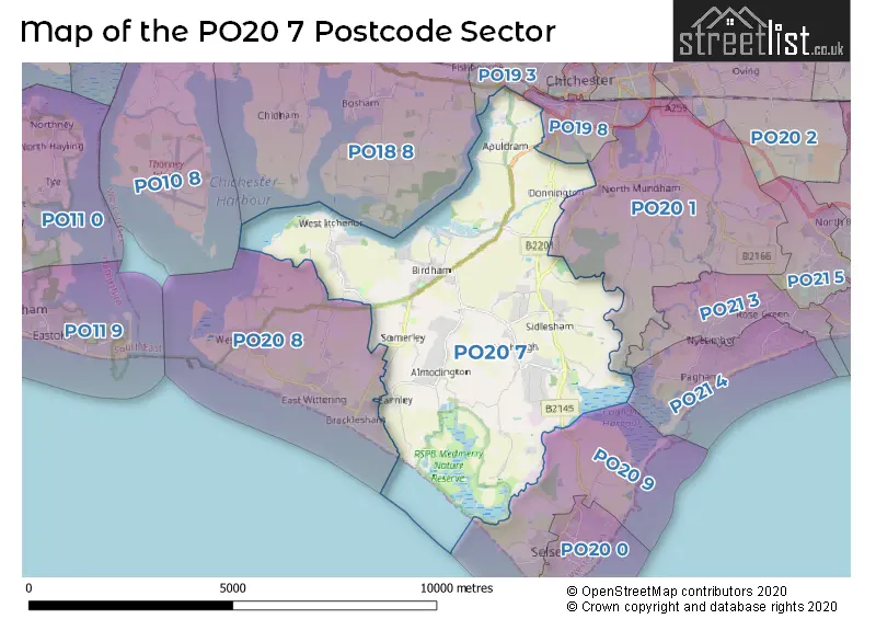
The PO20 7 Postcode shares a border with PO19 3 (CHICHESTER, West Broyle), PO19 8 (CHICHESTER), PO20 1 (Hunston, Runcton, North Mundham), PO20 8 (West Wittering, Bracklesham Bay, East Wittering) and PO20 9 (Selsey).
The sector is within the post town of CHICHESTER.
PO20 7 is a postcode sector within the PO20 postcode district which is within the PO Portsmouth postcode area.
The Royal Mail delivery office for the PO20 7 postal sector is the Chichester Delivery Office.
The area of the PO20 7 postcode sector is 16.09 square miles which is 41.66 square kilometres or 10,294.97 square acres.
The PO20 7 postcode sector is crossed by the A27 Major A road.
Waterways within the PO20 7 postcode sector include the Chichester Canal, River Lavant.

Map of the PO20 7 Postcode Sector
Explore the PO20 7 postcode sector by using our free interactive map.
| P | O | 2 | 0 | - | 7 | X | X |
| P | O | 2 | 0 | Space | 7 | Letter | Letter |
Official List of Streets
Birdham (36 Streets)
Almodington (3 Streets)
Earnley (9 Streets)
CHICHESTER (7 Streets)
Batchmere (4 Streets)
Sidlesham Common (8 Streets)
Sidlesham (17 Streets)
Itchenor (13 Streets)
Donnington (4 Streets)
Highleigh (2 Streets)
Unofficial Streets or Alternative Spellings
Hunston
SELSEY ROADSelsey
CHICHESTER ROADBracklesham Bay
BRACKLESHAM LANE CLAPPERS LANE HORNBEAM WALKEast Wittering
STUBCROFT LANEWest Wittering
SHEEPWASH LANESchools and Places of Education Within the PO20 7 Postcode Sector
Birdham CE Primary School
Voluntary controlled school
Crooked Lane, Chichester, West Sussex, PO20 7HB
Head: Mr Mark McCadden
Ofsted Rating: Good
Inspection: 2022-09-22 (609 days ago)
Website: Visit Birdham CE Primary School Website
Phone: 01243512399
Number of Pupils: 123
Sidlesham Primary School
Community school
Keynor Lane, Chichester, West Sussex, PO20 7NL
Head: Mrs Samantha Norton
Ofsted Rating: Good
Inspection: 2018-11-21 (2010 days ago)
Website: Visit Sidlesham Primary School Website
Phone: 01243641238
Number of Pupils: 139
House Prices in the PO20 7 Postcode Sector
| Type of Property | 2018 Average | 2018 Sales | 2017 Average | 2017 Sales | 2016 Average | 2016 Sales | 2015 Average | 2015 Sales |
|---|---|---|---|---|---|---|---|---|
| Detached | £671,856 | 35 | £785,547 | 50 | £725,009 | 38 | £625,817 | 47 |
| Semi-Detached | £351,000 | 8 | £369,750 | 8 | £383,286 | 7 | £361,056 | 9 |
| Terraced | £371,667 | 6 | £478,375 | 8 | £371,828 | 9 | £257,917 | 6 |
| Flats | £0 | 0 | £190,000 | 1 | £175,000 | 1 | £0 | 0 |
Important Postcodes PO20 7 in the Postcode Sector
PO20 7HB is the postcode for Birdham C of E Primary School, Crooked Lane
PO20 7NL is the postcode for Sidlesham Cp School, Keynor Lane, Sidlesham, and Sidlesham Cp School, Keynor Lane
| The PO20 7 Sector is within these Local Authorities |
|
|---|---|
| The PO20 7 Sector is within these Counties |
|
| The PO20 7 Sector is within these Water Company Areas |
|