The PR2 9 postcode sector is within the county of Lancashire.
Did you know? According to the 2021 Census, the PR2 9 postcode sector is home to a bustling 12,480 residents!
Given that each sector allows for 400 unique postcode combinations. Letters C, I, K, M, O and V are not allowed in the last two letters of a postcode. With 246 postcodes already in use, this leaves 154 units available.
The PR2 9 postal code covers the settlement of Fulwood.
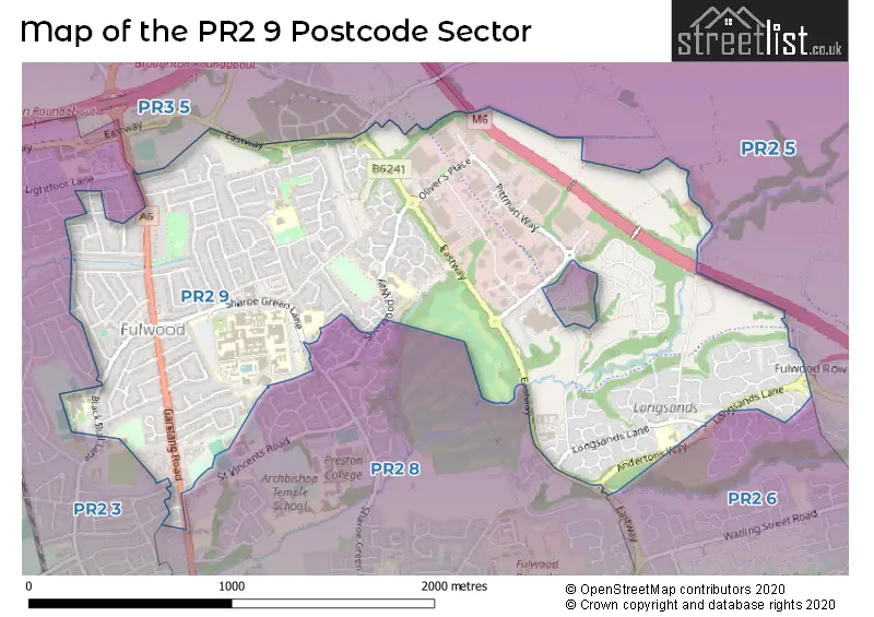
The PR2 9 Postcode shares a border with PR2 6 (Ribbleton, Fulwood), PR2 8 (Fulwood), PR3 5 (Broughton, Barton), PR2 3 (Fulwood, Ingol, PRESTON) and PR2 5 (Grimsargh, Ribbleton, Haighton).
The sector is within the post town of PRESTON.
PR2 9 is a postcode sector within the PR2 postcode district which is within the PR Preston postcode area.
The Royal Mail delivery office for the PR2 9 postal sector is the Preston Central Delivery Office.
The area of the PR2 9 postcode sector is 1.65 square miles which is 4.27 square kilometres or 1,054.74 square acres.
The PR2 9 postcode sector is crossed by the M6 motorway.
Waterways within the PR2 9 postcode sector include the Savick Brook.

Map of the PR2 9 Postcode Sector
Explore the PR2 9 postcode sector by using our free interactive map.
| P | R | 2 | - | 9 | X | X |
| P | R | 2 | Space | 9 | Letter | Letter |
Official List of Streets
Fulwood (179 Streets)
Unofficial Streets or Alternative Spellings
Fulwood
BEECH DRIVE BELTON HILL CONWAY DRIVE EASTWAY FULWOOD ROW INGLE HEAD KINGS DRIVE LANSDOWN HILL NOOKLANDS OAKWOOD DRIVE REGENT DRIVE ANDERTONS WAY GUILD WHEEL HAIGHTON INTERCHANGE HILL CREST AVENUE PITTMAN COURT SCOTTS WOOD ST VINCENTS ROAD SUMMERS BARN THE LODGINGSBroughton
DURTON LANEBarton
GARSTANG ROADSchools and Places of Education Within the PR2 9 Postcode Sector
Fulwood Academy
Academy sponsor led
Black Bull Lane, Preston, Lancashire, PR2 9YR
Head: Mr Andrew Galbraith
Ofsted Rating: Good
Inspection: 2023-06-07 (351 days ago)
Website: Visit Fulwood Academy Website
Phone: 01772719060
Number of Pupils: 759
Fulwood, St Peter's Church of England Primary School and Nursery
Voluntary aided school
Meadowfield, Preston, Lancashire, PR2 9RE
Head: Mr David Merritt
Ofsted Rating: Outstanding
Inspection: 2012-10-17 (4236 days ago)
Website: Visit Fulwood, St Peter's Church of England Primary School and Nursery Website
Phone: 01772864550
Number of Pupils: 250
Longsands Community Primary School
Community school
Longsands Lane, Preston, Lancashire, PR2 9PS
Head: Mrs Susan McKeown
Ofsted Rating: Good
Inspection: 2021-06-30 (1058 days ago)
Website: Visit Longsands Community Primary School Website
Phone: 01772795676
Number of Pupils: 208
Sherwood Primary School
Community school
Sherwood Way, Preston, Lancashire, PR2 9GA
Head: Mrs Jodie Lumb
Ofsted Rating: Outstanding
Inspection: 2012-05-30 (4376 days ago)
Website: Visit Sherwood Primary School Website
Phone: 01772719093
Number of Pupils: 425
House Prices in the PR2 9 Postcode Sector
| Type of Property | 2018 Average | 2018 Sales | 2017 Average | 2017 Sales | 2016 Average | 2016 Sales | 2015 Average | 2015 Sales |
|---|---|---|---|---|---|---|---|---|
| Detached | £271,247 | 106 | £271,403 | 77 | £243,122 | 65 | £244,270 | 61 |
| Semi-Detached | £177,136 | 102 | £172,708 | 106 | £180,257 | 92 | £167,059 | 123 |
| Terraced | £152,883 | 15 | £159,242 | 22 | £160,407 | 17 | £148,600 | 20 |
| Flats | £99,800 | 10 | £114,100 | 13 | £104,569 | 18 | £101,895 | 20 |
Important Postcodes PR2 9 in the Postcode Sector
PR2 9GA is the postcode for Sherwood Primary School, Sherwood Way
PR2 9GG is the postcode for PRESTON RTW, Royal Mail, Preston Mail Centre, Pittman Way, and Royal Mail, Preston Mail Centre, Pittman Way
PR2 9HH is the postcode for St. Clares Catholice Primary School, Sharoe Green Lane
PR2 9HT is the postcode for EDUCATION CENTRE TWO, Royal Preston Hospital, Sharoe Green Lane, RADIOTHERAPY OUTPATIENTS DEPARTMENT, Royal Preston Hospital, Sharoe Green Lane, Lancashire & South Cumbria NHS Foundation Trust, Avondale Unit Preston, SHAROE GREEN UNIT, Royal Preston Hospital, Sharoe Green Lane, Lancashire Teaching Hospitals NHS Foundation Trust, Royal Preston Hospital, MEDICAL REHABILITATION UNIT, Royal Preston Hospital, Sharoe Green Lane, AVONDALE UNIT, Royal Preston Hospital, Sharoe Green Lane, EDUCATION CENTRE ONE, Royal Preston Hospital, Sharoe Green Lane, and MAIN BUILDING, Royal Preston Hospital, Sharoe Green Lane
PR2 9NX is the postcode for Meadowfield House, Meadowfield
PR2 9NZ is the postcode for Driver & Vehicle Licensing Agency, Fulwood Park, Caxton Road
PR2 9PS is the postcode for Longsands Medical Centre, Longsands Lane, and Longsands Cp School, Longsands Lane
PR2 9RE is the postcode for St. Peters Primary School, Meadowfield
PR2 9RX is the postcode for Lancashire County Council, Fulwood Library, 294 Garstang Road
PR2 9YA is the postcode for Fulwood Leisure Centre, Black Bull Lane, and Fulwood Leisure Centre, Black Bull Lane, Fulwood
PR2 9YR is the postcode for MAIN BUILDING, Fulwood High School, Black Bull Lane, Fulwood High School, Black Bull Lane, and Fulwood Academy, Black Bull Lane
PR2 9ZZ is the postcode for LASCA, Caxton Road
| The PR2 9 Sector is within these Local Authorities |
|
|---|---|
| The PR2 9 Sector is within these Counties |
|
| The PR2 9 Sector is within these Water Company Areas |
|