The PR3 postcode district is a postal district located in the PR Preston postcode area with a population of 42,034 residents according to the 2021 England and Wales Census.
The area of the PR3 postcode district is 138.75 square miles which is 359.36 square kilometres or 88,799.45 acres.
Currently, the PR3 district has about 1308 postcode units spread across 6 geographic postcode sectors.
Given that each sector allows for 400 unique postcode combinations, the district has a capacity of 2,400 postcodes. With 1308 postcodes already in use, this leaves 1092 units available.
The largest settlement in the PR3 postal code is Longridge followed by Garstang, and Pilling.
The postcode area has a boundary with Morecambe Bay.
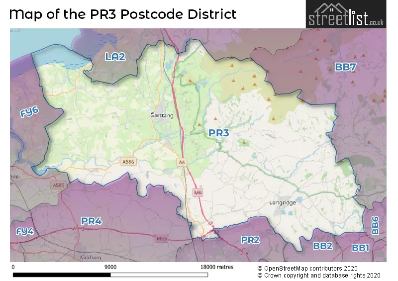
The PR3 Postcode shares a border with LA2 (Bentham, Ellel, Halton), BB1 (BLACKBURN, Rishton, Wilpshire), BB2 (BLACKBURN, Mellor, Mellor Brook), BB7 (CLITHEROE, Whalley, Barrow), PR2 (Fulwood, Ashton-on-Ribble, Ribbleton), PR4 (Kirkham, Cottam, Freckleton) and FY6 (POULTON-LE-FYLDE, Hambleton, Preesall).
The primary settlement in the PR3 postcode district is Claughton-on-Brock, located in the county of Lancashire, England. The most significant Postal Town in this district is Preston. Other notable settlements in this district include Bilsborrow, Cabus, Catterall, Churchtown, Forton, Garstang, Great Eccleston, and Little Eccleston.
For the district PR3, we have data on 8 postcode sectors. Here's a breakdown: The sector PR3 0, covers Great Eccleston and Claughton-On-Brock and Forton and Catterall in Lancashire. The sector PR3 1, covers Garstang in Lancashire. The sector PR3 2, covers Longridge and Goosnargh and Chipping in Lancashire. The sector PR3 3, covers Longridge and Ribchester in Lancashire. The sector PR3 5, covers Broughton and Barton in Lancashire. The sector PR3 6, covers Pilling and Out Rawcliffe in Lancashire. The sector PR3 8 is non-geographic. It's often designated for PO Boxes, large organisations, or special services. The sector PR3 9 is non-geographic. It's often designated for PO Boxes, large organisations, or special services.

Map of the PR3 Postcode District
Explore the PR3 postcode district by using our free interactive map.
When it comes to local government, postal geography often disregards political borders. However, for a breakdown in the PR3 District: the district mostly encompasses the Wyre District (B) (759 postcodes), followed by the Ribble Valley District (B) area (394 postcodes), followed by the Preston District (B) area (238 postcodes), and finally, the Fylde District (B) area (15 postcodes).
Recent House Sales in PR3
| Date | Price | Address |
|---|---|---|
| 23/10/2023 | £290,000 | Duckworth Drive, Catterall, Preston, PR3 1YS |
| 13/10/2023 | £205,000 | Georges Grove, Pilling, Preston, PR3 6DH |
| 12/10/2023 | £168,043 | Higher Road, Longridge, Preston, PR3 3SY |
| 06/10/2023 | £230,000 | Chester Brook, Ribchester, Preston, PR3 3XT |
| 06/10/2023 | £385,000 | Chester Close, Garstang, Preston, PR3 1LH |
| 06/10/2023 | £256,000 | St Annes Avenue, Great Eccleston, Preston, PR3 0DL |
| 06/10/2023 | £175,000 | Chesham Street, Great Eccleston, Preston, PR3 0YD |
| 29/09/2023 | £195,000 | Grizedale Avenue, Garstang, Preston, PR3 1ND |
| 26/09/2023 | £370,000 | Green Lane East, Cabus, Preston, PR3 1JS |
| 22/09/2023 | £425,000 | Moss Lane, Garstang, Preston, PR3 1HB |
Weather Forecast for PR3
Press Button to Show Forecast for Myerscough
| Time Period | Icon | Description | Temperature | Rain Probability | Wind |
|---|---|---|---|---|---|
| 03:00 to 06:00 | Clear night | 2.0°C (feels like -1.0°C) | 1.00% | E 7 mph | |
| 06:00 to 09:00 | Sunny day | 3.0°C (feels like 0.0°C) | 1.00% | ENE 4 mph | |
| 09:00 to 12:00 | Partly cloudy (day) | 7.0°C (feels like 6.0°C) | 1.00% | E 7 mph | |
| 12:00 to 15:00 | Cloudy | 9.0°C (feels like 8.0°C) | 6.00% | E 4 mph | |
| 15:00 to 18:00 | Cloudy | 10.0°C (feels like 9.0°C) | 9.00% | NE 4 mph | |
| 18:00 to 21:00 | Cloudy | 9.0°C (feels like 7.0°C) | 5.00% | N 7 mph | |
| 21:00 to 00:00 | Partly cloudy (night) | 5.0°C (feels like 3.0°C) | 3.00% | NE 7 mph |
Press Button to Show Forecast for Myerscough
| Time Period | Icon | Description | Temperature | Rain Probability | Wind |
|---|---|---|---|---|---|
| 00:00 to 03:00 | Partly cloudy (night) | 4.0°C (feels like 2.0°C) | 3.00% | E 7 mph | |
| 03:00 to 06:00 | Partly cloudy (night) | 3.0°C (feels like 1.0°C) | 4.00% | E 7 mph | |
| 06:00 to 09:00 | Partly cloudy (day) | 4.0°C (feels like 2.0°C) | 4.00% | ENE 7 mph | |
| 09:00 to 12:00 | Cloudy | 9.0°C (feels like 7.0°C) | 8.00% | E 9 mph | |
| 12:00 to 15:00 | Overcast | 11.0°C (feels like 9.0°C) | 12.00% | E 9 mph | |
| 15:00 to 18:00 | Cloudy | 11.0°C (feels like 9.0°C) | 11.00% | E 7 mph | |
| 18:00 to 21:00 | Cloudy | 10.0°C (feels like 8.0°C) | 12.00% | ENE 9 mph | |
| 21:00 to 00:00 | Partly cloudy (night) | 7.0°C (feels like 5.0°C) | 10.00% | ENE 9 mph |
Press Button to Show Forecast for Myerscough
| Time Period | Icon | Description | Temperature | Rain Probability | Wind |
|---|---|---|---|---|---|
| 00:00 to 03:00 | Cloudy | 6.0°C (feels like 3.0°C) | 14.00% | NE 9 mph | |
| 03:00 to 06:00 | Cloudy | 5.0°C (feels like 3.0°C) | 14.00% | NNE 9 mph | |
| 06:00 to 09:00 | Light rain | 7.0°C (feels like 4.0°C) | 44.00% | NNE 9 mph | |
| 09:00 to 12:00 | Cloudy | 8.0°C (feels like 6.0°C) | 19.00% | NNE 9 mph | |
| 12:00 to 15:00 | Light rain | 9.0°C (feels like 7.0°C) | 48.00% | NNE 11 mph | |
| 15:00 to 18:00 | Light rain | 10.0°C (feels like 8.0°C) | 51.00% | N 9 mph | |
| 18:00 to 21:00 | Partly cloudy (day) | 10.0°C (feels like 8.0°C) | 13.00% | NNW 11 mph | |
| 21:00 to 00:00 | Clear night | 8.0°C (feels like 5.0°C) | 9.00% | NW 9 mph |
Where is the PR3 Postcode District?
The postcode district PR3 is located in PRESTON. It is near the towns of Lancaster, Poulton-le-Fylde, Clitheroe, Blackburn, Leyland, and Morecambe. The district of PR3 is approximately 196.67 miles away from the center of London.
The district is within the post town of PRESTON.
The sector has postcodes within the nation of England.
The PR3 Postcode District is covers the following regions.
- Lancaster and Wyre - Lancashire - North West (England)
- Mid Lancashire - Lancashire - North West (England)
| Postcode Sector | Delivery Office |
|---|---|
| PR3 0 | Garstang Delivery Office |
| PR3 1 | Garstang Delivery Office |
| PR3 2 | Longridge Delivery Office |
| PR3 3 | Longridge Delivery Office |
| PR3 5 | Preston Central Delivery Office |
| PR3 6 | Garstang Delivery Office |
| PR3 8 | Longridge Delivery Office |
| P | R | 3 | - | X | X | X |
| P | R | 3 | Space | Numeric | Letter | Letter |
Current Monthly Rental Prices
| # Bedrooms | Min Price | Max Price | Avg Price |
|---|---|---|---|
| £395 | £715 | £614 | |
| 1 | £525 | £867 | £652 |
| 2 | £650 | £960 | £809 |
| 3 | £650 | £1,400 | £1,087 |
| 4 | £1,300 | £1,895 | £1,609 |
| 5 | £1,600 | £1,600 | £1,600 |
Current House Prices
| # Bedrooms | Min Price | Max Price | Avg Price |
|---|---|---|---|
| £35,000 | £600,000 | £274,533 | |
| 1 | £43,950 | £230,000 | £119,991 |
| 2 | £24,995 | £485,000 | £159,064 |
| 3 | £52,500 | £800,000 | £267,670 |
| 4 | £169,950 | £1,500,000 | £445,153 |
| 5 | £310,000 | £1,500,000 | £598,487 |
| 6 | £479,950 | £2,850,000 | £1,195,490 |
| 14 | £1,500,000 | £1,500,000 | £1,500,000 |
Estate Agents who Operate in the PR3 District
| Logo | Name | Brand Name | Address | Contact Number | Total Properties |
|---|---|---|---|---|---|
 | Garstang | Farrell Heyworth | 7 High Street, Garstang, PR3 1FA | 01995 910611 | 72 |
 | Garstang | LOVE HOMES | 16a High Street Garstang PR3 1FA | 01995 910357 | 59 |
 | Longridge | Dewhurst Homes | 8 Towneley Parade, Longridge, PR3 3HU | 01772 419374 | 57 |
 | Garstang | Dewhurst Homes | Appleton House, 1-2 Rope Walk Park Hill Road Garstang PR3 1NS | 01995 918848 | 47 |
 | Longridge | Holdens Estate Agents | 66 Derby Road, Longridge, PR3 3FE | 01772 503073 | 41 |
- Barton
- Bilsborrow
- Bonds
- Bowgreave
- Brook
- Broughton
- Bruna Hill
- Cabus
- Calder Vale
- Catterall
- Chipping
- Churchtown
- Copp
- Cumeragh Village
- Dolphinholme
- Eagland Hill
- Elswick
- Fisher's Row
- Ford Green
- Forton
- Fulwood
- Garstang
- Goosnargh
- Great Eccleston
- Hale Nook
- Hambleton
- Hesketh Lane
- Inglewhite
- Inskip Moss Side
- Inskip
- Knowle Green
- Larbreck
- Little Eccleston
- Longridge
- Matshead
- Moss Edge
- Moss Side
- Myerscough
- Nateby
- Newsham
- Out Rawcliffe
- Pilling
- Potters Brook
- Preesall
- Preston
- Ratten Row
- Ribchester
- Scorton
- Scronkey
- Skitham
- Smallwood Hey
- St Michael's on Wyre
- Stake Pool
- Ward Green Cross
- Whin Lane End
- Whitechapel
- Whittingham
- Winmarleigh
| Type of Property | 2018 Average | 2018 Sales | 2017 Average | 2017 Sales | 2016 Average | 2016 Sales | 2015 Average | 2015 Sales |
|---|---|---|---|---|---|---|---|---|
| Detached | £325,707 | 344 | £337,765 | 310 | £299,628 | 307 | £315,029 | 273 |
| Semi-Detached | £193,147 | 239 | £204,654 | 235 | £191,504 | 172 | £185,015 | 192 |
| Terraced | £149,958 | 159 | £151,209 | 129 | £166,867 | 202 | £155,935 | 136 |
| Flats | £172,305 | 36 | £158,023 | 65 | £141,911 | 17 | £131,878 | 40 |