The S26 4 postcode sector is within the county of South Yorkshire.
Did you know? According to the 2021 Census, the S26 4 postcode sector is home to a bustling 6,045 residents!
Given that each sector allows for 400 unique postcode combinations. Letters C, I, K, M, O and V are not allowed in the last two letters of a postcode. With 106 postcodes already in use, this leaves 294 units available.
The S26 4 postal code covers the settlement of Swallownest.
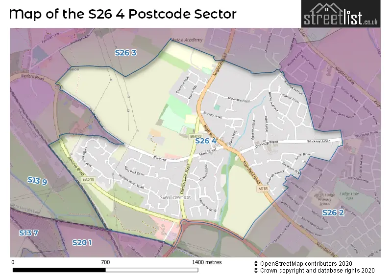
The S26 4 Postcode shares a border with S20 1 (Beighton), S26 2 (Aston), S26 3 (Aughton, Swallownest, Ulley) and S13 9 (SHEFFIELD, Handsworth, Woodhouse Mill).
The sector is within the post town of SHEFFIELD.
S26 4 is a postcode sector within the S26 postcode district which is within the S Sheffield postcode area.
The Royal Mail delivery office for the S26 4 postal sector is the Dinnington Delivery Office.
The area of the S26 4 postcode sector is 0.82 square miles which is 2.13 square kilometres or 525.41 square acres.

Map of the S26 4 Postcode Sector
Explore the S26 4 postcode sector by using our free interactive map.
| S | 2 | 6 | - | 4 | X | X |
| S | 2 | 6 | Space | 4 | Letter | Letter |
Official List of Streets
Swallownest (88 Streets)
Unofficial Streets or Alternative Spellings
Weather Forecast for S26 4
Press Button to Show Forecast for Beighton
| Time Period | Icon | Description | Temperature | Rain Probability | Wind |
|---|---|---|---|---|---|
| 12:00 to 15:00 | Heavy rain | 14.0°C (feels like 13.0°C) | 79.00% | NW 7 mph | |
| 15:00 to 18:00 | Heavy rain shower (day) | 14.0°C (feels like 13.0°C) | 60.00% | WNW 9 mph | |
| 18:00 to 21:00 | Heavy rain | 13.0°C (feels like 12.0°C) | 73.00% | W 9 mph | |
| 21:00 to 00:00 | Light rain | 12.0°C (feels like 10.0°C) | 48.00% | WSW 9 mph |
Press Button to Show Forecast for Beighton
| Time Period | Icon | Description | Temperature | Rain Probability | Wind |
|---|---|---|---|---|---|
| 00:00 to 03:00 | Overcast | 11.0°C (feels like 9.0°C) | 19.00% | WSW 7 mph | |
| 03:00 to 06:00 | Cloudy | 10.0°C (feels like 8.0°C) | 14.00% | SW 7 mph | |
| 06:00 to 09:00 | Cloudy | 10.0°C (feels like 8.0°C) | 10.00% | SW 9 mph | |
| 09:00 to 12:00 | Cloudy | 13.0°C (feels like 11.0°C) | 7.00% | SW 9 mph | |
| 12:00 to 15:00 | Cloudy | 15.0°C (feels like 13.0°C) | 8.00% | SSW 11 mph | |
| 15:00 to 18:00 | Cloudy | 16.0°C (feels like 14.0°C) | 10.00% | SSW 9 mph | |
| 18:00 to 21:00 | Cloudy | 15.0°C (feels like 14.0°C) | 10.00% | SSW 7 mph | |
| 21:00 to 00:00 | Cloudy | 11.0°C (feels like 10.0°C) | 7.00% | ESE 7 mph |
Press Button to Show Forecast for Beighton
| Time Period | Icon | Description | Temperature | Rain Probability | Wind |
|---|---|---|---|---|---|
| 00:00 to 03:00 | Cloudy | 10.0°C (feels like 9.0°C) | 9.00% | SSE 4 mph | |
| 03:00 to 06:00 | Cloudy | 9.0°C (feels like 8.0°C) | 10.00% | S 4 mph | |
| 06:00 to 09:00 | Cloudy | 10.0°C (feels like 9.0°C) | 9.00% | S 4 mph | |
| 09:00 to 12:00 | Cloudy | 12.0°C (feels like 12.0°C) | 14.00% | SE 7 mph | |
| 12:00 to 15:00 | Cloudy | 15.0°C (feels like 13.0°C) | 12.00% | SE 7 mph | |
| 15:00 to 18:00 | Cloudy | 15.0°C (feels like 13.0°C) | 13.00% | SE 9 mph | |
| 18:00 to 21:00 | Light rain shower (day) | 14.0°C (feels like 13.0°C) | 34.00% | SE 7 mph | |
| 21:00 to 00:00 | Cloudy | 11.0°C (feels like 10.0°C) | 8.00% | E 7 mph |
Schools and Places of Education Within the S26 4 Postcode Sector
Aston Academy
Academy converter
Aughton Road, Sheffield, South Yorkshire, S26 4SF
Head: Ms Afshah Saeed
Ofsted Rating: Requires improvement
Inspection: 2023-12-06 (149 days ago)
Website: Visit Aston Academy Website
Phone: 01142872171
Number of Pupils: 1590
House Prices in the S26 4 Postcode Sector
| Type of Property | 2018 Average | 2018 Sales | 2017 Average | 2017 Sales | 2016 Average | 2016 Sales | 2015 Average | 2015 Sales |
|---|---|---|---|---|---|---|---|---|
| Detached | £256,813 | 24 | £248,038 | 34 | £239,120 | 33 | £215,897 | 32 |
| Semi-Detached | £131,763 | 52 | £126,014 | 36 | £130,355 | 38 | £128,804 | 49 |
| Terraced | £101,685 | 14 | £104,278 | 20 | £107,405 | 21 | £111,470 | 22 |
| Flats | £72,905 | 5 | £76,250 | 2 | £74,500 | 2 | £80,500 | 7 |
Important Postcodes S26 4 in the Postcode Sector
S26 4SF is the postcode for MAIN BLOCK, Aston Academy, Aughton Road, CRAFT BLOCK, Aston Academy, Aughton Road, Aston Academy, Aughton Road, BLOCK I, Aston Academy, Aughton Road, and BLOCK H, Aston Academy, Aughton Road
S26 4TF is the postcode for Places for People Leisure Management Ltd, Aston cum Aughton Leisure Centre, Aughton Road, and Aston cum Aughton Leisure Centre, Aughton Road
S26 4TH is the postcode for HOSPITAL, SWALLOWNEST COURT, AUGHTON ROAD, CARE UNIT, SWALLOWNEST COURT, AUGHTON ROAD, OSPREY, SANDPIPER & KINGFISHER (PICU), Swallownest Court, Aughton Road, and Swallownest Court, Aughton Road
S26 4UR is the postcode for Swallownest Primary School, Rotherham Road, Swallownest, and Swallownest Primary School, Rotherham Road
S26 4WD is the postcode for Rotherham Metropolitan Borough Council, Aston Customer Service Centre, Worksop Road, and Rotherham Metropolitan Borough Council, Aston Customer Service Centre, Worksop Road, Swallownest
| The S26 4 Sector is within these Local Authorities |
|
|---|---|
| The S26 4 Sector is within these Counties |
|
| The S26 4 Sector is within these Water Company Areas |
|