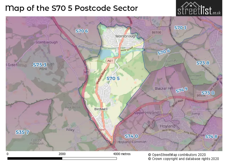
The S70 5 postcode sector is within the county of South Yorkshire.
Did you know? According to the 2021 Census, the S70 5 postcode sector is home to a bustling 7,794 residents!
Given that each sector allows for 400 unique postcode combinations. Letters C, I, K, M, O and V are not allowed in the last two letters of a postcode. With 255 postcodes already in use, this leaves 145 units available.
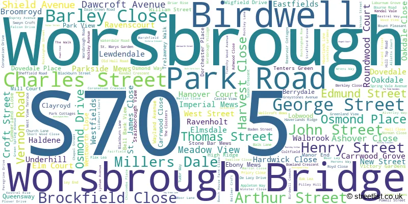
The largest settlement in the S70 5 postal code is Worsbrough followed by Birdwell, and Worsbrough Bridge.
The S70 5 Postcode shares a border with S70 4 (BARNSLEY, Worsbrough, Worsbrough Dale), S70 6 (BARNSLEY, Worsbrough), S74 0 (Hoyland, Jump, Blacker Hill), S74 9 (Hoyland) and S75 3 (Dodworth, Tankersley, Hood Green).
The sector is within the post town of BARNSLEY.
S70 5 is a postcode sector within the S7 postcode district which is within the S Sheffield postcode area.
The Royal Mail delivery office for the S70 5 postal sector is the unknown.
The area of the S70 5 postcode sector is 2.50 square miles which is 6.48 square kilometres or 1,601.07 square acres.
The S70 5 postcode sector is crossed by the M1 motorway.
The S70 5 postcode sector is crossed by the A61 Major A road.

Map of the S70 5 Postcode Sector
Explore the S70 5 postcode sector by using our free interactive map.
| S | 7 | 0 | - | 5 | X | X |
| S | 7 | 0 | Space | 5 | Letter | Letter |
Official List of Streets
Birdwell (64 Streets)
Worsbrough (100 Streets)
Worsbrough Bridge (5 Streets)
Unofficial Streets or Alternative Spellings
Goldthorpe
DEARNE VALLEY PARKWAYWorsbrough
EDMUNDS ROAD GENN LANE HIGH STREET HIGHROYDS LOBWOOD LANE NAPIER MOUNT STRAFFORD AVENUE YEWDALE BIRDWELL INTERCHANGE BLACKER LANE DARK LANE DOE LANE FAIR FIELD FERRAND STREET KINGWELL MEWS LABURNAM GROVE PARKVIEW ROCKINGHAM ROUNDABOUT STAMPERS HILL TANK TOP BRIDGE THE LOWER LIMESTankersley
PILLEY LANEWeather Forecast for S70 5
Press Button to Show Forecast for Hoyland
| Time Period | Icon | Description | Temperature | Rain Probability | Wind |
|---|---|---|---|---|---|
| 06:00 to 09:00 | Heavy rain | 5.0°C (feels like 1.0°C) | 94.00% | N 11 mph | |
| 09:00 to 12:00 | Heavy rain | 6.0°C (feels like 2.0°C) | 93.00% | NNW 13 mph | |
| 12:00 to 15:00 | Heavy rain | 6.0°C (feels like 2.0°C) | 88.00% | NW 13 mph | |
| 15:00 to 18:00 | Cloudy | 8.0°C (feels like 5.0°C) | 16.00% | WNW 13 mph | |
| 18:00 to 21:00 | Sunny day | 8.0°C (feels like 6.0°C) | 2.00% | W 11 mph | |
| 21:00 to 00:00 | Clear night | 5.0°C (feels like 3.0°C) | 1.00% | SW 7 mph |
Press Button to Show Forecast for Hoyland
| Time Period | Icon | Description | Temperature | Rain Probability | Wind |
|---|---|---|---|---|---|
| 00:00 to 03:00 | Clear night | 5.0°C (feels like 2.0°C) | 1.00% | SW 9 mph | |
| 03:00 to 06:00 | Clear night | 5.0°C (feels like 1.0°C) | 1.00% | SSW 9 mph | |
| 06:00 to 09:00 | Cloudy | 6.0°C (feels like 3.0°C) | 12.00% | SSW 11 mph | |
| 09:00 to 12:00 | Partly cloudy (day) | 10.0°C (feels like 7.0°C) | 1.00% | SSW 16 mph | |
| 12:00 to 15:00 | Cloudy | 13.0°C (feels like 10.0°C) | 8.00% | S 16 mph | |
| 15:00 to 18:00 | Cloudy | 13.0°C (feels like 10.0°C) | 13.00% | S 18 mph | |
| 18:00 to 21:00 | Cloudy | 12.0°C (feels like 10.0°C) | 8.00% | S 13 mph | |
| 21:00 to 00:00 | Partly cloudy (night) | 10.0°C (feels like 8.0°C) | 1.00% | S 13 mph |
Press Button to Show Forecast for Hoyland
| Time Period | Icon | Description | Temperature | Rain Probability | Wind |
|---|---|---|---|---|---|
| 00:00 to 03:00 | Partly cloudy (night) | 9.0°C (feels like 6.0°C) | 1.00% | SSE 11 mph | |
| 03:00 to 06:00 | Clear night | 7.0°C (feels like 5.0°C) | 1.00% | SSE 9 mph | |
| 06:00 to 09:00 | Sunny day | 7.0°C (feels like 5.0°C) | 2.00% | SE 9 mph | |
| 09:00 to 12:00 | Sunny day | 12.0°C (feels like 10.0°C) | 2.00% | SE 9 mph | |
| 12:00 to 15:00 | Cloudy | 16.0°C (feels like 13.0°C) | 8.00% | SE 13 mph | |
| 15:00 to 18:00 | Light rain shower (day) | 15.0°C (feels like 13.0°C) | 34.00% | SE 11 mph | |
| 18:00 to 21:00 | Light rain shower (day) | 14.0°C (feels like 12.0°C) | 36.00% | SE 9 mph | |
| 21:00 to 00:00 | Cloudy | 12.0°C (feels like 10.0°C) | 13.00% | ESE 7 mph |
Press Button to Show Forecast for Hoyland
| Time Period | Icon | Description | Temperature | Rain Probability | Wind |
|---|---|---|---|---|---|
| 00:00 to 03:00 | Cloudy | 10.0°C (feels like 9.0°C) | 15.00% | SE 4 mph | |
| 03:00 to 06:00 | Drizzle | 9.0°C (feels like 8.0°C) | 33.00% | N 4 mph | |
| 06:00 to 09:00 | Cloudy | 10.0°C (feels like 9.0°C) | 19.00% | N 4 mph | |
| 09:00 to 12:00 | Overcast | 12.0°C (feels like 11.0°C) | 20.00% | NE 4 mph | |
| 12:00 to 15:00 | Overcast | 15.0°C (feels like 15.0°C) | 16.00% | ENE 7 mph | |
| 15:00 to 18:00 | Cloudy | 16.0°C (feels like 15.0°C) | 14.00% | NE 7 mph | |
| 18:00 to 21:00 | Cloudy | 14.0°C (feels like 13.0°C) | 12.00% | NE 9 mph | |
| 21:00 to 00:00 | Light rain | 12.0°C (feels like 10.0°C) | 42.00% | NE 9 mph |
Schools and Places of Education Within the S70 5 Postcode Sector
The Mill Academy
Academy sponsor led
Lobwood, Barnsley, South Yorkshire, S70 5EP
Head: Mrs Rachel Chambers
Ofsted Rating: Good
Inspection: 2022-10-19 (557 days ago)
Website: Visit The Mill Academy Website
Phone: 01226289096
Number of Pupils: 225
Ward Green Primary School
Academy converter
Vernon Road, Barnsley, South Yorkshire, S70 5HJ
Head: Mrs Karen Trickett
Ofsted Rating: Good
Inspection: 2019-05-09 (1816 days ago)
Website: Visit Ward Green Primary School Website
Phone: 01226286510
Number of Pupils: 419
House Prices in the S70 5 Postcode Sector
| Type of Property | 2018 Average | 2018 Sales | 2017 Average | 2017 Sales | 2016 Average | 2016 Sales | 2015 Average | 2015 Sales |
|---|---|---|---|---|---|---|---|---|
| Detached | £191,755 | 39 | £194,001 | 36 | £198,951 | 33 | £181,288 | 34 |
| Semi-Detached | £119,149 | 50 | £117,078 | 39 | £109,998 | 40 | £101,579 | 48 |
| Terraced | £102,156 | 35 | £95,807 | 32 | £86,115 | 28 | £87,150 | 52 |
| Flats | £95,600 | 5 | £116,000 | 1 | £0 | 0 | £72,283 | 6 |
Important Postcodes S70 5 in the Postcode Sector
S70 5EP is the postcode for KEY STAGE 1, The Mill Academy, Lobwood, MAIN BLOCK, The Mill Academy, Lobwood, THE MILL ACADEMY, LOBWOOD, WORSBROUGH BRIDGE, and The Mill Academy, Lobwood
S70 5HJ is the postcode for Ward Green Primary School, Vernon Road, Worsbrough, Ward Green Primary, Vernon Road, and Ward Green Primary, Vernon Road, Worsbrough
S70 5LJ is the postcode for Worsbrough Mill Museum, Park Road
S70 5NQ is the postcode for TWO STOREY CLASSROOM BLOCK, Wigfield Farm, Haverlands Lane, Wigfield Farm, Haverlands Lane, and WORKSHOPS, Wigfield Farm, Haverlands Lane
S70 5NT is the postcode for 1, Mount Pleasant, Worsbrough
S70 5NZ is the postcode for Worsbrough Primary Healthcare Centre, Powell Street, and WORSBROUGH PRIMARY HEALTH CENTRE, POWELL STREET, WORSBROUGH BRIDGE
S70 5XB is the postcode for Birdwell Primary School, Sheffield Road, and Birdwell Primary School, Sheffield Road, Birdwell
| The S70 5 Sector is within these Local Authorities |
|
|---|---|
| The S70 5 Sector is within these Counties |
|
| The S70 5 Sector is within these Water Company Areas |
|