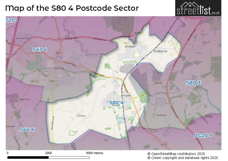
The S80 4 postcode sector stands on the Derbyshire and Nottinghamshire border.
Did you know? According to the 2021 Census, the S80 4 postcode sector is home to a bustling 10,353 residents!
Given that each sector allows for 400 unique postcode combinations. Letters C, I, K, M, O and V are not allowed in the last two letters of a postcode. With 294 postcodes already in use, this leaves 106 units available.
The largest settlement in the S80 4 postal code is Creswell followed by Whitwell, and Hodthorpe.
The S80 4 Postcode shares a border with NG20 9 (Langwith, Meden Vale, Langwith Junction), S43 4 (Clowne, Barlborough), S44 6 (Bolsover, Shuttlewood, Stanfree) and S80 3 (WORKSOP, Rhodesia, Welbeck).
The sector is within the post town of WORKSOP.
S80 4 is a postcode sector within the S8 postcode district which is within the S Sheffield postcode area.
The Royal Mail delivery office for the S80 4 postal sector is the unknown.
The area of the S80 4 postcode sector is 6.71 square miles which is 17.37 square kilometres or 4,291.27 square acres.
Waterways within the S80 4 postcode sector include the Millwood Brook.

Map of the S80 4 Postcode Sector
Explore the S80 4 postcode sector by using our free interactive map.
| S | 8 | 0 | - | 4 | X | X |
| S | 8 | 0 | Space | 4 | Letter | Letter |
Official List of Streets
Creswell (92 Streets)
Whitwell (72 Streets)
Hodthorpe (17 Streets)
Oxcroft (1 Streets)
Belph (1 Streets)
Unofficial Streets or Alternative Spellings
Whitwell
GEORGE INN COURTDarfoulds
CHESTERFIELD ROAD RATCLIFFE LANEClowne
MANSFIELD ROAD MARKLAND LANE SHEFFIELD ROADBarlborough
WORKSOP ROADCuckney
CRESWELL ROADBolsover
OXCROFT LANESchools and Places of Education Within the S80 4 Postcode Sector
Creswell CofE Controlled Infant and Nursery
Voluntary controlled school
Gypsy Lane, Worksop, Nottinghamshire, S80 4HY
Head: Mrs Amanda Dodd
Ofsted Rating: Good
Inspection: 2020-01-09 (1609 days ago)
Website: Visit Creswell CofE Controlled Infant and Nursery Website
Phone: 01909721471
Number of Pupils: 257
Creswell Junior School
Community school
Elmton Road, Worksop, Nottinghamshire, S80 4JD
Head: Mrs Alison Pymm
Ofsted Rating: Good
Inspection: 2023-03-22 (441 days ago)
Website: Visit Creswell Junior School Website
Phone: 01909721260
Number of Pupils: 256
Hodthorpe Primary School
Academy converter
Queen's Road, Worksop, Nottinghamshire, S80 4UT
Head: Mrs Nicola Fretwell-Evans
Ofsted Rating: Good
Inspection: 2023-10-25 (224 days ago)
Website: Visit Hodthorpe Primary School Website
Phone: 01909720315
Number of Pupils: 61
Whitwell Primary School
Community school
Southfield Lane, Worksop, Nottinghamshire, S80 4NR
Head: Mrs Sarah Tomlinson
Ofsted Rating: Good
Inspection: 2023-12-14 (174 days ago)
Website: Visit Whitwell Primary School Website
Phone: 01909720251
Number of Pupils: 265
House Prices in the S80 4 Postcode Sector
| Type of Property | 2018 Average | 2018 Sales | 2017 Average | 2017 Sales | 2016 Average | 2016 Sales | 2015 Average | 2015 Sales |
|---|---|---|---|---|---|---|---|---|
| Detached | £218,640 | 63 | £208,651 | 37 | £215,856 | 45 | £165,875 | 20 |
| Semi-Detached | £117,217 | 61 | £114,308 | 79 | £104,589 | 59 | £111,794 | 58 |
| Terraced | £85,014 | 70 | £74,481 | 48 | £78,344 | 73 | £74,685 | 68 |
| Flats | £119,000 | 3 | £0 | 0 | £46,000 | 2 | £0 | 0 |
Important Postcodes S80 4 in the Postcode Sector
S80 4AS is the postcode for Creswell Leisure Centre, Duke Street
S80 4HA is the postcode for CRESWELL MEDICAL CENTRE,, WELBECK STREET,
S80 4HY is the postcode for Creswell C of E Infant & Nursery School, Gypsy Lane, and Main Building, Creswell C of E Infant & Nursery School, Gypsy Lane
S80 4JD is the postcode for Main Building, Creswell Junior School, Elmton Road, and Creswell Junior School, Elmton Road
S80 4JE is the postcode for Creswell CE Infant & Nursery School, Elmton Road
S80 4NT is the postcode for Whitwell Primary School, Southfield Ln, Whitwell, and Whitwell Primary School, Southfield Lane
S80 4QR is the postcode for Whitwell Health Centre, The Square
S80 4UT is the postcode for HODTHORPE PRIMARY SCHOOL, QUEENS ROAD, HODTHORPE
| The S80 4 Sector is within these Local Authorities |
|
|---|---|
| The S80 4 Sector is within these Counties |
|
| The S80 4 Sector is within these Water Company Areas |
|