The SL8 5 postcode sector stands on the Berkshire and Buckinghamshire border.
Did you know? According to the 2021 Census, the SL8 5 postcode sector is home to a bustling 6,758 residents!
Given that each sector allows for 400 unique postcode combinations. Letters C, I, K, M, O and V are not allowed in the last two letters of a postcode. With 267 postcodes already in use, this leaves 133 units available.
The SL8 5 postal code covers the settlement of BOURNE END.
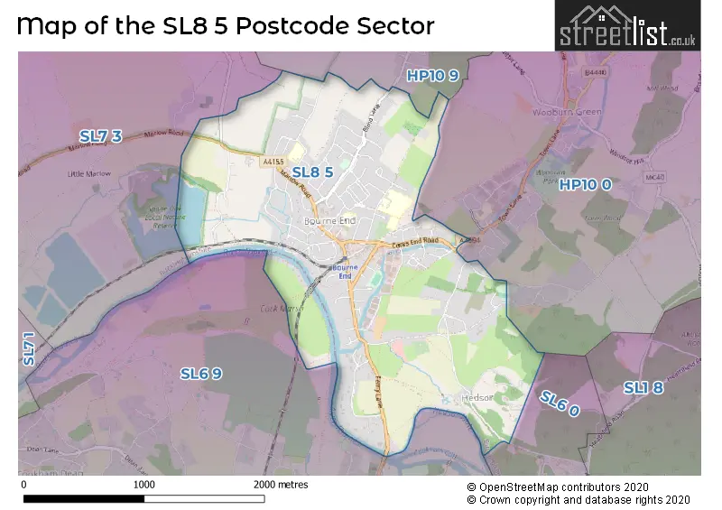
The SL8 5 Postcode shares a border with SL7 3 (MARLOW, Booker, Little Marlow), SL6 0 (Taplow, Dorney Reach), SL6 9 (Cookham), HP10 0 (Wooburn Green, Wooburn Moor, Wooburn Town) and HP10 9 (Flackwell Heath, Loudwater, HIGH WYCOMBE).
The sector is within the post town of BOURNE END.
SL8 5 is a postcode sector within the SL8 postcode district which is within the SL Slough postcode area.
The Royal Mail delivery office for the SL8 5 postal sector is the Bourne End Scale Payment Delivery Office.
The area of the SL8 5 postcode sector is 2.11 square miles which is 5.47 square kilometres or 1,350.72 square acres.
Waterways within the SL8 5 postcode sector include the River Thames, River Wye.

Map of the SL8 5 Postcode Sector
Explore the SL8 5 postcode sector by using our free interactive map.
| S | L | 8 | - | 5 | X | X |
| S | L | 8 | Space | 5 | Letter | Letter |
Official List of Streets
BOURNE END (101 Streets)
Unofficial Streets or Alternative Spellings
Wooburn Green
BROOKBANK BROOKHOUSE DRIVE KILN LANEBOURNE END
CRESSINGTON COURT KENNET ROADCookham
FERRY LANEFlackwell Heath
BLIND LANE CHAPMAN LANEMARLOW
SHEEPRIDGE LANELittle Marlow
MARLOW ROADSchools and Places of Education Within the SL8 5 Postcode Sector
Bourne End Academy
Academy sponsor led
New Road, Bourne End, Buckinghamshire, SL8 5BW
Head: Miss Kerri-Anne Leavy
Ofsted Rating: Good
Inspection: 2022-09-28 (603 days ago)
Website: Visit Bourne End Academy Website
Phone: 01628819022
Number of Pupils: 823
Claytons Primary School
Community school
Wendover Road, Bourne End, Buckinghamshire, SL8 5NS
Head: Mrs Jensa Carter
Ofsted Rating: Good
Inspection: 2023-07-04 (324 days ago)
Website: Visit Claytons Primary School Website
Phone: 01628525277
Number of Pupils: 300
Westfield School
Community special school
Highfield Road, Bourne End, Buckinghamshire, SL8 5BE
Head: Ms Tara Deakes
Ofsted Rating: Good
Inspection: 2018-05-15 (2200 days ago)
Website: Visit Westfield School Website
Phone: 01628533125
Number of Pupils: 78
House Prices in the SL8 5 Postcode Sector
| Type of Property | 2018 Average | 2018 Sales | 2017 Average | 2017 Sales | 2016 Average | 2016 Sales | 2015 Average | 2015 Sales |
|---|---|---|---|---|---|---|---|---|
| Detached | £1,038,184 | 40 | £967,785 | 36 | £780,358 | 39 | £793,900 | 44 |
| Semi-Detached | £493,696 | 38 | £520,355 | 21 | £508,792 | 41 | £437,731 | 31 |
| Terraced | £387,731 | 13 | £375,303 | 18 | £431,409 | 17 | £444,738 | 29 |
| Flats | £324,412 | 17 | £331,338 | 35 | £360,876 | 48 | £242,381 | 21 |
Important Postcodes SL8 5 in the Postcode Sector
SL8 5BE is the postcode for Westfield School, Highfield Road, and WESTFIELD SCHOOL, HIGHFIELD ROAD, BOURNE END
SL8 5BW is the postcode for MAIN BLOCK, Bourne End Academy, New Road, and WRIGHT/AOT BLOCK, Bourne End Academy, New Road
SL8 5NS is the postcode for Claytons Primary School, Wendover Road, and CLAYTONS PRIMARY SCHOOL, WENDOVER ROAD, BOURNE END
SL8 5SX is the postcode for Buckinghamshire County Council, Bourne End Library, Wakeman Road
| The SL8 5 Sector is within these Local Authorities |
|
|---|---|
| The SL8 5 Sector is within these Counties |
|
| The SL8 5 Sector is within these Water Company Areas |
|