The SN10 3 postcode sector is within the county of Wiltshire.
Did you know? According to the 2021 Census, the SN10 3 postcode sector is home to a bustling 7,307 residents!
Given that each sector allows for 400 unique postcode combinations. Letters C, I, K, M, O and V are not allowed in the last two letters of a postcode. With 246 postcodes already in use, this leaves 154 units available.
The largest settlement in the SN10 3 postal code is DEVIZES followed by All Cannings, and Chirton.
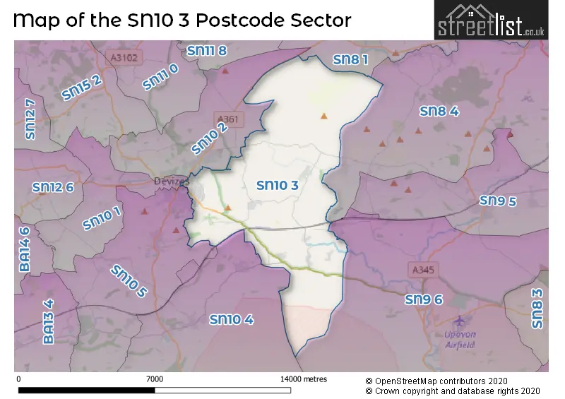
The SN10 3 Postcode shares a border with SN8 1 (MARLBOROUGH, Ogbourne St. George, Avebury), SN8 4 (MARLBOROUGH, West Overton, Oare), SN9 6 (Upavon, Enford, Manningford Bruce), SN10 1 (DEVIZES, Poulshot, Bulkington), SN10 2 (DEVIZES, Rowde, Bishop's Cannings), SN10 4 (Market Lavington, Urchfont, West Lavington) and SN10 5 (DEVIZES, Potterne, Great Cheverell).
The sector is within the post town of DEVIZES.
SN10 3 is a postcode sector within the SN10 postcode district which is within the SN Swindon postcode area.
The Royal Mail delivery office for the SN10 3 postal sector is the Devizes Delivery Office.
The area of the SN10 3 postcode sector is 27.65 square miles which is 71.62 square kilometres or 17,697.74 square acres.
Waterways within the SN10 3 postcode sector include the Kennet & Avon Canal, River Avon.

Map of the SN10 3 Postcode Sector
Explore the SN10 3 postcode sector by using our free interactive map.
| S | N | 1 | 0 | - | 3 | X | X |
| S | N | 1 | 0 | Space | 3 | Letter | Letter |
Official List of Streets
DEVIZES (72 Streets)
Chirton (10 Streets)
All Cannings (12 Streets)
Etchilhampton (3 Streets)
Coate (3 Streets)
Lydeway (1 Streets)
Wedhampton (4 Streets)
Marden (2 Streets)
Nursteed (2 Streets)
Unofficial Streets or Alternative Spellings
Stanton St. Bernard
CHURCH ROAD ALL CANNINGS BRIDGE ALLINGTON BRIDGE ALLINGTON LANE BYSTONE LANE CARTWAY CHANDLER CLOSE COATE LANE CONOCK EASTON FARM ROAD ETCHILHAMPTON FIELDSIDE GIPSY LANE GRANGEFIELD GREEN GATE ROAD JOHN RUMBLE CLOSE JOHN RUMBLE COURT JUMP FARM ROAD LIPGATE MONUMENT HILL OSTLERS YARD PARK VIEW PEWSEY ROAD PIG LANE PUB LANE SHACKELTON ROAD SPANIELS BRIDGE ROAD STERT VALLEY LANE STROUD LANE THE CROFT THE MEADOWS THE OLD MANOR ROAD THE WILLOWS THUMWOOD TERRACE WANSDYKE PATH WHITE HORSE TRAIL, MID WILTS WAY AND WANSDYKE PATH WHITE ROAD WOODWAY BRIDGEBeechingstoke
WOODBOROUGH ROADNursteed
NURSTEED MEADOWSDEVIZES
MILLENNIUM CLOSE PROUDMAN ROAD SOUTHBROOM ROAD THE GREEN WINDSOR DRIVEPotterne
COXHILL LANESchools and Places of Education Within the SN10 3 Postcode Sector
All Cannings Church of England Primary School
Academy converter
Chandlers Lane, Devizes, Wiltshire, SN10 3PG
Head: Mr Richard Borman
Ofsted Rating: Good
Inspection: 2022-11-02 (580 days ago)
Website: Visit All Cannings Church of England Primary School Website
Phone: 01380860676
Number of Pupils: 154
Chirton Church of England Primary School
Academy converter
The Street, Devizes, Wiltshire, SN10 3QS
Head: Mrs Amy Bekker Wrench
Ofsted Rating: Good
Inspection: 2023-05-18 (383 days ago)
Website: Visit Chirton Church of England Primary School Website
Phone: 01380840684
Number of Pupils: 77
Devizes School
Academy converter
The Green, Devizes, Wiltshire, SN10 3AG
Head: Mr David Cooper
Ofsted Rating: Good
Inspection: 2019-03-12 (1911 days ago)
Website: Visit Devizes School Website
Phone: 01380724886
Number of Pupils: 1211
Nursteed Community Primary School
Community school
Brickley Lane, Devizes, Wiltshire, SN10 3BF
Head: Mrs Kay Vousden
Ofsted Rating: Requires improvement
Inspection: 2023-03-01 (461 days ago)
Website: Visit Nursteed Community Primary School Website
Phone: 01380730538
Number of Pupils: 199
Southbroom St James Academy
Academy sponsor led
Nursteed Road, Devizes, Wiltshire, SN10 3AH
Head: Mr Gareth Bailey
Ofsted Rating: Good
Inspection: 2018-09-26 (2078 days ago)
Website: Visit Southbroom St James Academy Website
Phone: 01380723232
Number of Pupils: 158
House Prices in the SN10 3 Postcode Sector
| Type of Property | 2018 Average | 2018 Sales | 2017 Average | 2017 Sales | 2016 Average | 2016 Sales | 2015 Average | 2015 Sales |
|---|---|---|---|---|---|---|---|---|
| Detached | £400,491 | 29 | £394,441 | 51 | £397,351 | 30 | £443,877 | 48 |
| Semi-Detached | £234,586 | 28 | £257,764 | 38 | £230,123 | 32 | £222,138 | 44 |
| Terraced | £214,442 | 41 | £220,866 | 28 | £185,093 | 45 | £165,224 | 36 |
| Flats | £114,714 | 7 | £123,500 | 6 | £103,429 | 7 | £109,095 | 10 |
Important Postcodes SN10 3 in the Postcode Sector
SN10 3AF is the postcode for Bradbury Manor, Nursteed Road, and Southbroom Junior School, Nursteed Road
SN10 3AG is the postcode for CDT, Devizes School, The Green, MIDDLE SCHOOL, Devizes School, The Green, SCIENCE BUILDING, Devizes School, The Green, BLOCK B, Devizes School, The Green, and MAIN BUILDING, Devizes School, The Green
SN10 3BF is the postcode for Nursteed Primary School, Brickley Lane
SN10 3PG is the postcode for All Cannings C of E Primary School, Chandlers Lane, All Cannings
SN10 3UF is the postcode for Practice Plus Group Surgical Centre, Marshall Road
| The SN10 3 Sector is within these Local Authorities |
|
|---|---|
| The SN10 3 Sector is within these Counties |
|
| The SN10 3 Sector is within these Water Company Areas |
|