The SN25 6 postcode sector is within the county of Wiltshire.
Did you know? According to the 2021 Census, the SN25 6 postcode sector is home to a bustling 90 residents!
Given that each sector allows for 400 unique postcode combinations. Letters C, I, K, M, O and V are not allowed in the last two letters of a postcode. With 7 postcodes already in use, this leaves 393 units available.
The SN25 6 postal code covers the settlement of SWINDON.
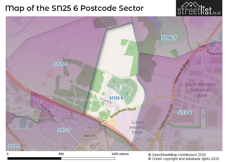
The SN25 6 Postcode shares a border with SN3 4 (SWINDON, South Marston, Stratton), SN6 7 (Highworth, Hannington, Coleshill), SN26 7 (Blunsdon), SN2 7 (SWINDON) and SN25 5 (Groundwell Industrial Estate, Blunsdon, SWINDON).
The sector is within the post town of SWINDON.
SN25 6 is a postcode sector within the SN2 postcode district which is within the SN Swindon postcode area.
The Royal Mail delivery office for the SN25 6 postal sector is the unknown.
The area of the SN25 6 postcode sector is 0.40 square miles which is 1.04 square kilometres or 256.11 square acres.
The SN25 6 postcode sector is crossed by the A419 Major A road.

Map of the SN25 6 Postcode Sector
Explore the SN25 6 postcode sector by using our free interactive map.
| S | N | 2 | 5 | - | 6 | X | X |
| S | N | 2 | 5 | Space | 6 | Letter | Letter |
Official List of Streets
Unofficial Streets or Alternative Spellings
House Prices in the SN25 6 Postcode Sector
| Type of Property | 2018 Average | 2018 Sales | 2017 Average | 2017 Sales | 2016 Average | 2016 Sales | 2015 Average | 2015 Sales |
|---|---|---|---|---|---|---|---|---|
| Detached | £305,000 | 2 | £0 | 0 | £0 | 0 | £0 | 0 |
| Semi-Detached | £338,000 | 3 | £0 | 0 | £0 | 0 | £0 | 0 |
| Terraced | £0 | 0 | £0 | 0 | £0 | 0 | £0 | 0 |
| Flats | £0 | 0 | £0 | 0 | £0 | 0 | £0 | 0 |
| The SN25 6 Sector is within these Local Authorities |
|
|---|---|
| The SN25 6 Sector is within these Counties |
|
| The SN25 6 Sector is within these Water Company Areas |
|