The SO16 2 postcode sector is within the county of Hampshire.
Did you know? According to the 2021 Census, the SO16 2 postcode sector is home to a bustling 1,274 residents!
Given that each sector allows for 400 unique postcode combinations. Letters C, I, K, M, O and V are not allowed in the last two letters of a postcode. With 34 postcodes already in use, this leaves 366 units available.
The SO16 2 postal code covers the settlement of SOUTHAMPTON.
The SO16 2 Postcode shares a border with SO16 3 (SOUTHAMPTON, Chilworth), SO17 3 (SOUTHAMPTON), SO50 9 (EASTLEIGH), SO18 2 (SOUTHAMPTON, Southampton International Airport) and SO50 5 (EASTLEIGH).
The sector is within the post town of SOUTHAMPTON.
SO16 2 is a postcode sector within the SO16 postcode district which is within the SO Southampton postcode area.
The Royal Mail delivery office for the SO16 2 postal sector is the Shirley (so) Delivery Office.
The area of the SO16 2 postcode sector is 0.22 square miles which is 0.57 square kilometres or 141.43 square acres.
The SO16 2 postcode sector is crossed by the M27 motorway.
Waterways within the SO16 2 postcode sector include the Monks Brook.

Map of the SO16 2 Postcode Sector
Explore the SO16 2 postcode sector by using our free interactive map.
| S | O | 1 | 6 | - | 2 | X | X |
| S | O | 1 | 6 | Space | 2 | Letter | Letter |
Official List of Streets
SOUTHAMPTON (13 Streets)
Unofficial Streets or Alternative Spellings
Southampton International Airport
WIDE LANESOUTHAMPTON
BASSETT GREEN ROAD BURGESS ROAD CARNATION ROAD ETHELBURT AVENUEEASTLEIGH,
STONEHAM LANE MONKS BROOK GREENWAY STONEHAM INTERCHANGE STONEHAM WAY WESSEX CRESCENT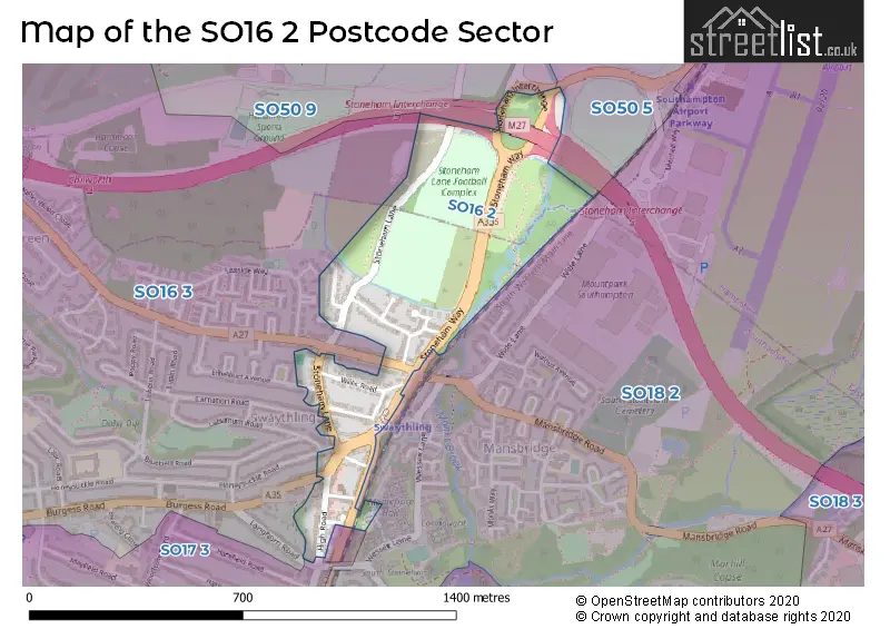
House Prices in the SO16 2 Postcode Sector
| Type of Property | 2018 Average | 2018 Sales | 2017 Average | 2017 Sales | 2016 Average | 2016 Sales | 2015 Average | 2015 Sales |
|---|---|---|---|---|---|---|---|---|
| Detached | £286,750 | 4 | £324,180 | 5 | £405,000 | 2 | £325,000 | 1 |
| Semi-Detached | £248,400 | 5 | £314,375 | 4 | £280,893 | 7 | £247,500 | 2 |
| Terraced | £217,000 | 1 | £0 | 0 | £230,000 | 1 | £179,665 | 3 |
| Flats | £182,000 | 3 | £146,000 | 3 | £164,000 | 2 | £150,417 | 6 |
Important Postcodes SO16 2 in the Postcode Sector
SO16 2HA is the postcode for BLOCK C, 110, High Road, BLOCK B EXCLUDING RETAIL AREAS, 110, High Road, BLOCK A EXCLUDING RETAIL AREAS, 110, High Road, BLOCK C, CITY GATEWAY, 110 HIGH ROAD, and BLOCK D EXCLUDING RETAIL AREA AND MEDICAL CENTRE, 110, High Road
SO16 2JA is the postcode for Stoneham Lane Surgery, Parkville Road
| The SO16 2 Sector is within these Local Authorities |
|
|---|---|
| The SO16 2 Sector is within these Counties |
|
| The SO16 2 Sector is within these Water Company Areas |
|