The SO16 5 postcode sector is within the county of Hampshire.
Did you know? According to the 2021 Census, the SO16 5 postcode sector is home to a bustling 7,457 residents!
Given that each sector allows for 400 unique postcode combinations. Letters C, I, K, M, O and V are not allowed in the last two letters of a postcode. With 165 postcodes already in use, this leaves 235 units available.
The SO16 5 postal code covers the settlement of SOUTHAMPTON.
The SO16 5 Postcode shares a border with SO16 6 (SOUTHAMPTON), SO16 7 (SOUTHAMPTON, Chilworth), SO16 8 (SOUTHAMPTON, Rownhams, Nursling) and SO16 9 (SOUTHAMPTON).
The sector is within the post town of SOUTHAMPTON.
SO16 5 is a postcode sector within the SO16 postcode district which is within the SO Southampton postcode area.
The Royal Mail delivery office for the SO16 5 postal sector is the Shirley (so) Delivery Office.
The area of the SO16 5 postcode sector is 0.52 square miles which is 1.34 square kilometres or 331.83 square acres.
Waterways within the SO16 5 postcode sector include the Tanners Brook.

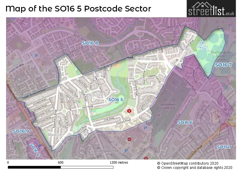
Map of the SO16 5 Postcode Sector
Explore the SO16 5 postcode sector by using our free interactive map.
| S | O | 1 | 6 | - | 5 | X | X |
| S | O | 1 | 6 | Space | 5 | Letter | Letter |
Official List of Streets
SOUTHAMPTON (52 Streets)
Unofficial Streets or Alternative Spellings
SOUTHAMPTON
COXFORD CLOSE DUNKIRK CLOSE DUNKIRK ROAD LONGLEAT GARDENS LORDSWOOD ROAD LOWER BROWNHILL ROAD OAKWOOD DRIVE ORION CLOSE PETWORTH GARDENS ROBINIA GREEN TANGMERE DRIVE THORNDIKE ROAD TREMONA ROAD WARREN AVENUE WITTERING ROAD ALDERMOOR TURNING CIRCLE BIG KIDS LINE DUEL JEX BLAKE CLOSE LORDS HILL CENTRE EAST LORDS HILL WAY LORDSDALE GREENWAY PUMP TRACK ROWNHAMS COURT WILLOW COURTNursling
ROMSEY ROADSchools and Places of Education Within the SO16 5 Postcode Sector
Rosewood Free School
Free schools special
Aldermoor Road, Southampton, Hampshire, SO16 5NA
Head: Zoe Evans
Ofsted Rating: Outstanding
Inspection: 2023-10-12 (224 days ago)
Website: Visit Rosewood Free School Website
Phone: 02380571050
Number of Pupils: 65
House Prices in the SO16 5 Postcode Sector
| Type of Property | 2018 Average | 2018 Sales | 2017 Average | 2017 Sales | 2016 Average | 2016 Sales | 2015 Average | 2015 Sales |
|---|---|---|---|---|---|---|---|---|
| Detached | £270,375 | 8 | £277,056 | 9 | £242,000 | 5 | £237,500 | 4 |
| Semi-Detached | £216,772 | 34 | £209,627 | 31 | £200,157 | 51 | £181,234 | 37 |
| Terraced | £217,967 | 30 | £197,303 | 28 | £180,672 | 23 | £161,465 | 32 |
| Flats | £138,997 | 15 | £148,230 | 15 | £139,843 | 23 | £120,448 | 20 |
Important Postcodes SO16 5 in the Postcode Sector
SO16 5AF is the postcode for NATIONAL BLOOD SERVICE, COXFORD ROAD, SOUTHAMPTON, and National Blood Service, Southampton Centre, Coxford Road
SO16 5LH is the postcode for 315, Coxford Road
SO16 5ST is the postcode for Aldermoor Health Centre, Aldermoor Close
SO16 5YA is the postcode for PRINCESS ANNE HOSPITAL, COXFORD ROAD, SOUTHAMPTON, and Princess Anne Hospital, Coxford Road
| The SO16 5 Sector is within these Local Authorities |
|
|---|---|
| The SO16 5 Sector is within these Counties |
|
| The SO16 5 Sector is within these Water Company Areas |
|