The SO22 6 postcode sector is within the county of Hampshire.
Did you know? According to the 2021 Census, the SO22 6 postcode sector is home to a bustling 10,829 residents!
Given that each sector allows for 400 unique postcode combinations. Letters C, I, K, M, O and V are not allowed in the last two letters of a postcode. With 254 postcodes already in use, this leaves 146 units available.
The largest settlements in the SO22 6 postal code are WINCHESTER and Littleton.
The SO22 6 Postcode shares a border with SO22 5 (WINCHESTER, Pitt), SO23 8 (WINCHESTER), SO21 2 (Otterbourne, Hursley, Compton) and SO23 7 (WINCHESTER, Kings Worthy, Headbourne Worthy).
The sector is within the post town of WINCHESTER.
SO22 6 is a postcode sector within the SO22 postcode district which is within the SO Southampton postcode area.
The Royal Mail delivery office for the SO22 6 postal sector is the Winchester Delivery Office.
The area of the SO22 6 postcode sector is 3.38 square miles which is 8.75 square kilometres or 2,163.15 square acres.
The SO22 6 postcode sector is crossed by the A34 Major A road.

Map of the SO22 6 Postcode Sector
Explore the SO22 6 postcode sector by using our free interactive map.
| S | O | 2 | 2 | - | 6 | X | X |
| S | O | 2 | 2 | Space | 6 | Letter | Letter |
Official List of Streets
WINCHESTER (128 Streets)
Littleton (30 Streets)
Harestock (1 Streets)
Headbourne Worthy (1 Streets)
Unofficial Streets or Alternative Spellings
WINCHESTER
BURNETT CLOSE CHERITON ROAD ELM ROAD FORDINGTON ROAD GODWIN CLOSE SALTERS LANE THE FIRS WESTERN ROADHeadbourne Worthy
DOWN FARM LANESparsholt
STOCKBRIDGE ROAD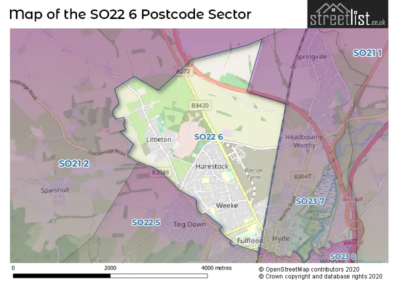
House Prices in the SO22 6 Postcode Sector
| Type of Property | 2018 Average | 2018 Sales | 2017 Average | 2017 Sales | 2016 Average | 2016 Sales | 2015 Average | 2015 Sales |
|---|---|---|---|---|---|---|---|---|
| Detached | £815,979 | 52 | £777,964 | 54 | £834,701 | 56 | £652,767 | 60 |
| Semi-Detached | £554,994 | 49 | £496,462 | 41 | £490,627 | 39 | £395,035 | 39 |
| Terraced | £464,132 | 51 | £507,357 | 65 | £475,835 | 30 | £397,971 | 60 |
| Flats | £323,639 | 32 | £294,500 | 16 | £257,826 | 21 | £316,694 | 24 |
Important Postcodes SO22 6 in the Postcode Sector
SO22 6AB is the postcode for MAIN BUILDING, Milesdown, Winton Close, and Four Chimneys, Winton Close
SO22 6AJ is the postcode for Lanterns Children Centre, Bereweeke Road
SO22 6DR is the postcode for Weeke Primary School, Stoney Lane, and Adult & Higher Education, Stoney Lane
SO22 6EL is the postcode for The Friarsgate Practice, Stockbridge Road
SO22 6JJ is the postcode for G BLOCK, Henry Beaufort School, Harestock, Henry Beaufort School, Harestock, T BLOCK, Henry Beaufort School, Harestock, PRAGUE, Henry Beaufort School, Harestock, W BLOCK AND TEACHING BLOCK, Henry Beaufort School, Harestock, W BLOCK, Henry Beaufort School, Harestock, COMMUNITY MUSIC BLOCK, Henry Beaufort School, Harestock, PERFORMING ARTS BLOCK, Henry Beaufort School, Harestock, S BLOCK, Henry Beaufort School, Harestock, MATHS BLOCK, Henry Beaufort School, Harestock, WINCHESTER BLOCK, Henry Beaufort School, Harestock, and SPORTS HALL, Henry Beaufort School, Harestock
SO22 6LU is the postcode for Harestock Primary School, Bramshaw Close
SO22 6RX is the postcode for THE HOPKINS BUILDING, Peter Symonds College, Owens Road, COLLEGE CENTRE, Peter Symonds College, Owens Road, ASHURST, Peter Symonds College, Owens Road, PAUL WOODHOUSE CENTRE, Peter Symonds College, Owens Road, SCIENCE CENTRE, Peter Symonds College, Owens Road, NORTHBROOK, Peter Symonds College, Owens Road, MERCERS SPORTS HALL, Peter Symonds College, Owens Road, SCHOOL HOUSE RESIDENTIAL, Peter Symonds College, Owens Road, CONLAN BUILDING, Peter Symonds College, Owens Road, PRODUCT DESIGN, Peter Symonds College, Owens Road, KELSO, Peter Symonds College, Owens Road, VARLEY, Peter Symonds College, Owens Road, ART BUILDING, Peter Symonds College, Owens Road, JOHN SHIELDS BUILDING, Peter Symonds College, Owens Road, FALKLANDS LODGE RESIDENTIAL, Peter Symonds College, Owens Road, FREEMAN, Peter Symonds College, Owens Road, SCIENCE ANNEXE, Peter Symonds College, Owens Road, NICHOLLS PAVILLION, Peter Symonds College, Owens Road, and WYKE LODGE, Peter Symonds College, Owens Road
| The SO22 6 Sector is within these Local Authorities |
|
|---|---|
| The SO22 6 Sector is within these Counties |
|
| The SO22 6 Sector is within these Water Company Areas |
|