The SS17 8 postcode sector is within the county of Essex.
Did you know? According to the 2021 Census, the SS17 8 postcode sector is home to a bustling 8,968 residents!
Given that each sector allows for 400 unique postcode combinations. Letters C, I, K, M, O and V are not allowed in the last two letters of a postcode. With 185 postcodes already in use, this leaves 215 units available.
The largest settlement in the SS17 8 postal code is STANFORD-LE-HOPE followed by Horndon-on-the-Hill, and Corringham.
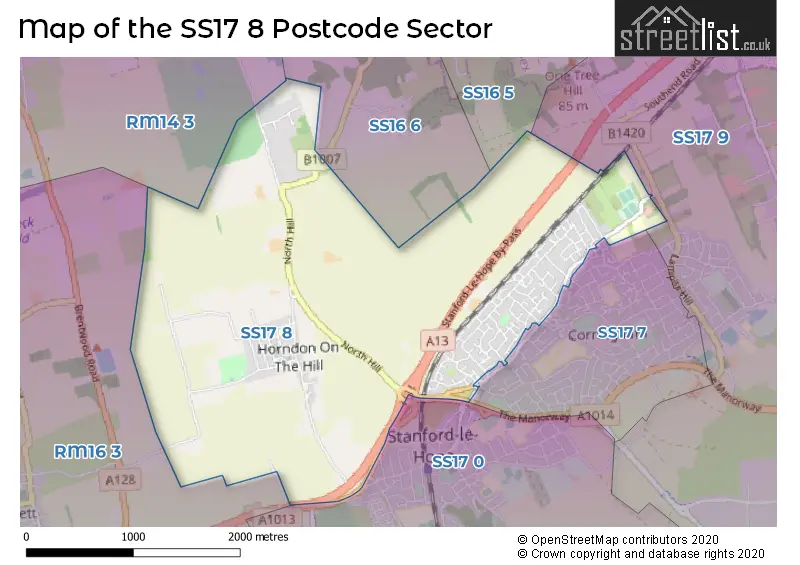
The SS17 8 Postcode shares a border with SS16 5 (BASILDON, Langdon Hills, Vange), SS16 6 (Langdon Hills, BASILDON), RM14 3 (UPMINSTER, Bulphan, NORTH OCKENDON), RM16 3 (Orsett, CHADWELL ST MARY, NORTH STIFFORD), SS17 0 (STANFORD-LE-HOPE, Linford), SS17 7 (Corringham, STANFORD-LE-HOPE) and SS17 9 (Corringham, STANFORD-LE-HOPE, Fobbing).
The sector is within the post town of STANFORD-LE-HOPE.
SS17 8 is a postcode sector within the SS17 postcode district which is within the SS Southend-on-Sea postcode area.
The Royal Mail delivery office for the SS17 8 postal sector is the Stanford Le Hope Delivery Office.
The area of the SS17 8 postcode sector is 4.03 square miles which is 10.44 square kilometres or 2,580.55 square acres.

Map of the SS17 8 Postcode Sector
Explore the SS17 8 postcode sector by using our free interactive map.
| S | S | 1 | 7 | - | 8 | X | X |
| S | S | 1 | 7 | Space | 8 | Letter | Letter |
Official List of Streets
STANFORD-LE-HOPE (74 Streets)
Horndon-on-the-Hill (26 Streets)
Unofficial Streets or Alternative Spellings
Corringham
ASHDOWN CLOSE MACKLEY DRIVE SPRINGHOUSE ROAD THE MANORWAY WILLIAMSONS WAYOrsett
STANFORD ROAD 29-37 ODD FRANCIS CLOSE BENTON GARDENS BRANKSOME PARK FP 213 FP 85 FP86 KIRKHAM AVENUE KIRKHAM SHAW LEONARD MEWS MALVINA CLOSE MORLEY LINK NORTHLANDS FARM CHASE SAFFRON GARDENS STANFORD-LE-HOPE BY-PASS STANS WALK WILLOWHILLSTANFORD-LE-HOPE
LONDON ROADHorndon-on-the-Hill
BY-PASS ROADLangdon Hills
SOUTH HILLBulphan
FARRIERS WAY LOWER DUNTON ROADSchools and Places of Education Within the SS17 8 Postcode Sector
Horndon-On-the-Hill CofE Primary School
Academy converter
Hillcrest Road, Stanford-le-Hope, Essex, SS17 8LR
Head: Deborah Bradley
Ofsted Rating: Good
Inspection: 2023-09-27 (239 days ago)
Website: Visit Horndon-On-the-Hill CofE Primary School Website
Phone: 01375673260
Number of Pupils: 237
Ortu Gable Hall School
Academy converter
Southend Road, Stanford-le-Hope, Essex, SS17 8JT
Head: Mr Gary Lewis
Ofsted Rating: Serious Weaknesses
Inspection: 2022-05-05 (749 days ago)
Website: Visit Ortu Gable Hall School Website
Phone: 01375400800
Number of Pupils: 1318
House Prices in the SS17 8 Postcode Sector
| Type of Property | 2018 Average | 2018 Sales | 2017 Average | 2017 Sales | 2016 Average | 2016 Sales | 2015 Average | 2015 Sales |
|---|---|---|---|---|---|---|---|---|
| Detached | £525,250 | 20 | £532,763 | 19 | £478,289 | 19 | £492,708 | 18 |
| Semi-Detached | £321,107 | 42 | £327,800 | 50 | £318,254 | 55 | £276,640 | 42 |
| Terraced | £275,307 | 48 | £270,775 | 38 | £257,760 | 48 | £224,640 | 39 |
| Flats | £167,498 | 3 | £180,654 | 13 | £147,769 | 8 | £153,438 | 8 |
Important Postcodes SS17 8 in the Postcode Sector
SS17 8JT is the postcode for Gable Hall School, Southend Road, TECHNOLOGY (WORKSHOPS) BLOCK, Gable Hall School, Southend Road, SIXTH FROM BLOCK, Gable Hall School, Southend Road, and SPORTS HALL, Gable Hall School, Southend Road
SS17 8LR is the postcode for Main Building, Horndon-on-the-Hill C of E Primary School, Hillcrest Road, and Horndon-on-the-Hill C of E Primary School, Hillcrest Road
| The SS17 8 Sector is within these Local Authorities |
|
|---|---|
| The SS17 8 Sector is within these Counties |
|
| The SS17 8 Sector is within these Water Company Areas |
|