The ST3 1 postcode sector is within the county of Staffordshire.
Did you know? According to the 2021 Census, the ST3 1 postcode sector is home to a bustling 5,483 residents!
Given that each sector allows for 400 unique postcode combinations. Letters C, I, K, M, O and V are not allowed in the last two letters of a postcode. With 210 postcodes already in use, this leaves 190 units available.
The largest settlements in the ST3 1 postal code are STOKE-ON-TRENT and Longton.
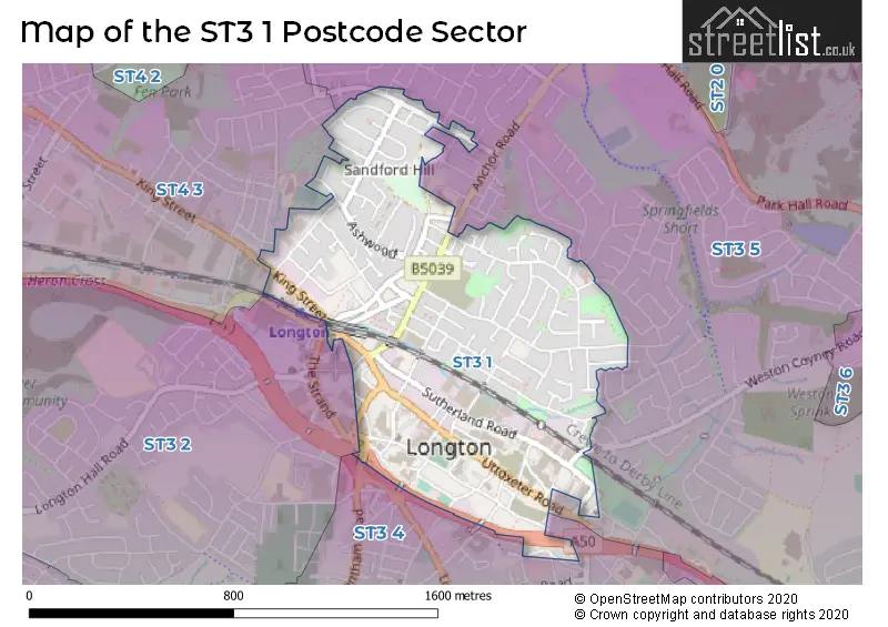
The ST3 1 Postcode shares a border with ST3 2 (STOKE-ON-TRENT, Longton), ST3 4 (STOKE-ON-TRENT), ST3 5 (STOKE-ON-TRENT, Weston Coyney) and ST4 3 (STOKE-ON-TRENT).
The sector is within the post town of STOKE-ON-TRENT.
ST3 1 is a postcode sector within the ST3 postcode district which is within the ST Stoke-on-Trent postcode area.
The Royal Mail delivery office for the ST3 1 postal sector is the Longton Delivery Office.
The area of the ST3 1 postcode sector is 0.55 square miles which is 1.43 square kilometres or 352.57 square acres.
The ST3 1 postcode sector is crossed by the A50 Major A road.

Map of the ST3 1 Postcode Sector
Explore the ST3 1 postcode sector by using our free interactive map.
| S | T | 3 | - | 1 | X | X |
| S | T | 3 | Space | 1 | Letter | Letter |
Official List of Streets
STOKE-ON-TRENT (125 Streets)
Unofficial Streets or Alternative Spellings
STOKE-ON-TRENT
BATHS ROAD CORINA WAY DEANSCROFT WAY FURNACE ROAD GOLDENHILL ROAD HATHERSAGE CLOSE LINNBURN ROAD MELBOURNE STREET MOSSLAND ROAD PEVENSEY GROVE PITSFORD STREET SPEEDWALL STREET THE STRAND WESTON COYNEY ROAD BARLOW STREET BEECH STREET BENNION STREET CHURCH GARDENS COTTONWOOD GROVE GOWER STREET HAIG STREET HARBER STREET HEATHS PASSAGE HERBERT STREET KINGCROSS STREET LIGHTWOOD BRIDGE LOWER CROSS STREET LOWS PASSAGE MARCH ROAD MEIRHAY ROAD MILLFIELD FOOTBRIDGE MOULTON ROAD PALMER STREET RAILWAY TERRACE SANDFORD STREET SHEAF PASSAGE SMITHY LANE SPEERMAN BRIDGE ST MARTINS LANEBlythe Bridge
UTTOXETER ROADWeather Forecast for ST3 1
Press Button to Show Forecast for Longton
| Time Period | Icon | Description | Temperature | Rain Probability | Wind |
|---|---|---|---|---|---|
| 15:00 to 18:00 | Cloudy | 12.0°C (feels like 8.0°C) | 16.00% | S 20 mph | |
| 18:00 to 21:00 | Cloudy | 11.0°C (feels like 7.0°C) | 46.00% | S 18 mph | |
| 21:00 to 00:00 | Overcast | 10.0°C (feels like 7.0°C) | 19.00% | S 16 mph |
Press Button to Show Forecast for Longton
| Time Period | Icon | Description | Temperature | Rain Probability | Wind |
|---|---|---|---|---|---|
| 00:00 to 03:00 | Cloudy | 9.0°C (feels like 6.0°C) | 7.00% | SSE 13 mph | |
| 03:00 to 06:00 | Cloudy | 8.0°C (feels like 5.0°C) | 5.00% | SE 13 mph | |
| 06:00 to 09:00 | Cloudy | 8.0°C (feels like 4.0°C) | 4.00% | SE 16 mph | |
| 09:00 to 12:00 | Partly cloudy (day) | 11.0°C (feels like 8.0°C) | 1.00% | SSE 18 mph | |
| 12:00 to 15:00 | Partly cloudy (day) | 15.0°C (feels like 11.0°C) | 5.00% | SSE 18 mph | |
| 15:00 to 18:00 | Cloudy | 15.0°C (feels like 12.0°C) | 9.00% | SSE 16 mph | |
| 18:00 to 21:00 | Cloudy | 13.0°C (feels like 11.0°C) | 13.00% | S 9 mph | |
| 21:00 to 00:00 | Overcast | 10.0°C (feels like 9.0°C) | 13.00% | SE 7 mph |
Press Button to Show Forecast for Longton
| Time Period | Icon | Description | Temperature | Rain Probability | Wind |
|---|---|---|---|---|---|
| 00:00 to 03:00 | Overcast | 10.0°C (feels like 8.0°C) | 14.00% | SSE 7 mph | |
| 03:00 to 06:00 | Cloudy | 9.0°C (feels like 7.0°C) | 11.00% | SE 4 mph | |
| 06:00 to 09:00 | Cloudy | 8.0°C (feels like 7.0°C) | 6.00% | SE 4 mph | |
| 09:00 to 12:00 | Cloudy | 11.0°C (feels like 10.0°C) | 6.00% | SSE 4 mph | |
| 12:00 to 15:00 | Cloudy | 13.0°C (feels like 13.0°C) | 10.00% | SSE 4 mph | |
| 15:00 to 18:00 | Cloudy | 15.0°C (feels like 14.0°C) | 10.00% | ESE 4 mph | |
| 18:00 to 21:00 | Cloudy | 14.0°C (feels like 13.0°C) | 11.00% | NNE 4 mph | |
| 21:00 to 00:00 | Cloudy | 11.0°C (feels like 10.0°C) | 11.00% | N 7 mph |
Press Button to Show Forecast for Longton
| Time Period | Icon | Description | Temperature | Rain Probability | Wind |
|---|---|---|---|---|---|
| 00:00 to 03:00 | Cloudy | 10.0°C (feels like 9.0°C) | 14.00% | N 7 mph | |
| 03:00 to 06:00 | Cloudy | 10.0°C (feels like 8.0°C) | 13.00% | NNW 7 mph | |
| 06:00 to 09:00 | Cloudy | 10.0°C (feels like 8.0°C) | 11.00% | NNW 7 mph | |
| 09:00 to 12:00 | Cloudy | 12.0°C (feels like 11.0°C) | 12.00% | NNW 9 mph | |
| 12:00 to 15:00 | Cloudy | 15.0°C (feels like 13.0°C) | 8.00% | NNW 11 mph | |
| 15:00 to 18:00 | Cloudy | 16.0°C (feels like 14.0°C) | 7.00% | N 11 mph | |
| 18:00 to 21:00 | Partly cloudy (day) | 15.0°C (feels like 13.0°C) | 4.00% | N 11 mph | |
| 21:00 to 00:00 | Clear night | 11.0°C (feels like 9.0°C) | 1.00% | N 9 mph |
House Prices in the ST3 1 Postcode Sector
| Type of Property | 2018 Average | 2018 Sales | 2017 Average | 2017 Sales | 2016 Average | 2016 Sales | 2015 Average | 2015 Sales |
|---|---|---|---|---|---|---|---|---|
| Detached | £155,875 | 4 | £141,681 | 8 | £105,333 | 3 | £131,000 | 6 |
| Semi-Detached | £114,089 | 44 | £108,129 | 59 | £109,238 | 47 | £105,764 | 38 |
| Terraced | £78,385 | 31 | £83,899 | 45 | £81,191 | 34 | £68,605 | 22 |
| Flats | £44,500 | 1 | £80,000 | 1 | £0 | 0 | £0 | 0 |
Important Postcodes ST3 1 in the Postcode Sector
ST3 1BS is the postcode for 54-58 MARKET STREET, LONGTON
ST3 1BZ is the postcode for Longton Town Hall, Times Square
ST3 1EQ is the postcode for Longton Health Centre, Drayton Road
ST3 1HH is the postcode for AMENITIES, Staffordshire Police, Police Station, Sutherland Road, LONGTON POLICE STATION, SUTHERLAND ROAD, LONGTON, and Staffordshire Police, Police Station, Sutherland Road
ST3 1NS is the postcode for Staffordshire Fire & Rescue, Longton Community Fire Station, Uttoxeter Road, and Staffordshire Fire & Rescue Service, Fire Station, Uttoxeter Road
ST3 1QZ is the postcode for Westfield Nursery School, Queensberry Road
| The ST3 1 Sector is within these Local Authorities |
|
|---|---|
| The ST3 1 Sector is within these Counties |
|
| The ST3 1 Sector is within these Water Company Areas |
|