The TN14 6 postcode sector is within the county of Kent.
Did you know? According to the 2021 Census, the TN14 6 postcode sector is home to a bustling 3,462 residents!
Given that each sector allows for 400 unique postcode combinations. Letters C, I, K, M, O and V are not allowed in the last two letters of a postcode. With 156 postcodes already in use, this leaves 244 units available.
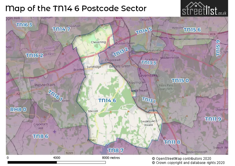
The largest settlement in the TN14 6 postal code is SUNDRIDGE followed by Weald, and IDE HILL.
The TN14 6 Postcode shares a border with TN13 1 (SEVENOAKS), TN13 2 (RIVERHEAD, SEVENOAKS, DUNTON GREEN), TN11 8 (Penshurst, Leigh, Hildenborough), TN15 0 (SEAL, Plaxtol, SEVENOAKS), TN16 1 (WESTERHAM , BRASTED ), TN8 6 (EDENBRIDGE, CROCKHAM HILL, Four Elms), TN8 7 (Cowden, Hever, Chiddingstone) and TN14 7 (HALSTEAD, Knockholt, SHOREHAM).
The sector is within the post town of SEVENOAKS.
TN14 6 is a postcode sector within the TN14 postcode district which is within the TN Tonbridge postcode area.
The Royal Mail delivery office for the TN14 6 postal sector is the Sevenoaks Delivery Office.
The area of the TN14 6 postcode sector is 14.61 square miles which is 37.83 square kilometres or 9,348.10 square acres.
The TN14 6 postcode sector is crossed by the M25 motorway.
The TN14 6 postcode sector is crossed by the M26 motorway.
The TN14 6 postcode sector is crossed by the A21 Major A road.
Waterways within the TN14 6 postcode sector include the Darenth.


Map of the TN14 6 Postcode Sector
Explore the TN14 6 postcode sector by using our free interactive map.
| T | N | 1 | 4 | - | 6 | X | X |
| T | N | 1 | 4 | Space | 6 | Letter | Letter |
Official List of Streets
Ide Hill (17 Streets)
SEVENOAKS (4 Streets)
Weald (22 Streets)
Sundridge (16 Streets)
Chevening (2 Streets)
Dunton Green (3 Streets)
Unofficial Streets or Alternative Spellings
SEVENOAKS
COLD ARBOR ROAD OAK LANE WESTERHAM ROADChiddingstone
HALE OAK ROADKnockholt
SUNDRIDGE HILLWeather Forecast for TN14 6
Press Button to Show Forecast for Emmetts Garden
| Time Period | Icon | Description | Temperature | Rain Probability | Wind |
|---|---|---|---|---|---|
| 06:00 to 09:00 | Sunny day | 7.0°C (feels like 4.0°C) | 1.00% | S 11 mph | |
| 09:00 to 12:00 | Partly cloudy (day) | 10.0°C (feels like 7.0°C) | 0.00% | SSW 16 mph | |
| 12:00 to 15:00 | Sunny day | 12.0°C (feels like 9.0°C) | 1.00% | SSW 18 mph | |
| 15:00 to 18:00 | Sunny day | 12.0°C (feels like 9.0°C) | 0.00% | SSW 16 mph | |
| 18:00 to 21:00 | Sunny day | 11.0°C (feels like 9.0°C) | 0.00% | SSW 9 mph | |
| 21:00 to 00:00 | Clear night | 8.0°C (feels like 6.0°C) | 0.00% | SE 9 mph |
Press Button to Show Forecast for Emmetts Garden
| Time Period | Icon | Description | Temperature | Rain Probability | Wind |
|---|---|---|---|---|---|
| 00:00 to 03:00 | Clear night | 8.0°C (feels like 5.0°C) | 0.00% | SE 9 mph | |
| 03:00 to 06:00 | Clear night | 7.0°C (feels like 4.0°C) | 0.00% | SE 9 mph | |
| 06:00 to 09:00 | Sunny day | 8.0°C (feels like 6.0°C) | 1.00% | SE 9 mph | |
| 09:00 to 12:00 | Sunny day | 13.0°C (feels like 11.0°C) | 1.00% | SSE 11 mph | |
| 12:00 to 15:00 | Cloudy | 14.0°C (feels like 12.0°C) | 8.00% | SSE 11 mph | |
| 15:00 to 18:00 | Cloudy | 13.0°C (feels like 11.0°C) | 11.00% | SSE 11 mph | |
| 18:00 to 21:00 | Partly cloudy (day) | 13.0°C (feels like 11.0°C) | 7.00% | SSE 9 mph | |
| 21:00 to 00:00 | Partly cloudy (night) | 10.0°C (feels like 8.0°C) | 8.00% | SE 7 mph |
Press Button to Show Forecast for Emmetts Garden
| Time Period | Icon | Description | Temperature | Rain Probability | Wind |
|---|---|---|---|---|---|
| 00:00 to 03:00 | Cloudy | 9.0°C (feels like 7.0°C) | 9.00% | SSE 7 mph | |
| 03:00 to 06:00 | Cloudy | 8.0°C (feels like 7.0°C) | 11.00% | S 4 mph | |
| 06:00 to 09:00 | Cloudy | 8.0°C (feels like 8.0°C) | 10.00% | N 4 mph | |
| 09:00 to 12:00 | Cloudy | 11.0°C (feels like 11.0°C) | 12.00% | NNW 4 mph | |
| 12:00 to 15:00 | Cloudy | 14.0°C (feels like 13.0°C) | 18.00% | ENE 4 mph | |
| 15:00 to 18:00 | Cloudy | 14.0°C (feels like 13.0°C) | 14.00% | NW 7 mph | |
| 18:00 to 21:00 | Cloudy | 13.0°C (feels like 12.0°C) | 15.00% | N 9 mph | |
| 21:00 to 00:00 | Cloudy | 11.0°C (feels like 10.0°C) | 19.00% | WNW 7 mph |
Press Button to Show Forecast for Emmetts Garden
| Time Period | Icon | Description | Temperature | Rain Probability | Wind |
|---|---|---|---|---|---|
| 00:00 to 03:00 | Light rain shower (night) | 10.0°C (feels like 8.0°C) | 37.00% | WNW 9 mph | |
| 03:00 to 06:00 | Overcast | 9.0°C (feels like 8.0°C) | 15.00% | NW 9 mph | |
| 06:00 to 09:00 | Overcast | 10.0°C (feels like 8.0°C) | 16.00% | WNW 9 mph | |
| 09:00 to 12:00 | Overcast | 12.0°C (feels like 10.0°C) | 16.00% | WNW 9 mph | |
| 12:00 to 15:00 | Cloudy | 15.0°C (feels like 13.0°C) | 11.00% | NW 9 mph | |
| 15:00 to 18:00 | Cloudy | 16.0°C (feels like 14.0°C) | 12.00% | NW 9 mph | |
| 18:00 to 21:00 | Partly cloudy (day) | 15.0°C (feels like 13.0°C) | 8.00% | NNW 9 mph | |
| 21:00 to 00:00 | Partly cloudy (night) | 12.0°C (feels like 10.0°C) | 4.00% | NNW 9 mph |
Schools and Places of Education Within the TN14 6 Postcode Sector
Ide Hill Church of England Primary School
Voluntary aided school
Sundridge Road, Sevenoaks, Kent, TN14 6JT
Head: Mrs Louisa Hillman
Ofsted Rating: Good
Inspection: 2019-04-04 (1852 days ago)
Website: Visit Ide Hill Church of England Primary School Website
Phone: 01732750389
Number of Pupils: 153
Sundridge and Brasted Church of England Voluntary Controlled Primary School
Voluntary controlled school
Church Road, Sevenoaks, Kent, TN14 6EA
Head: Mr Tom Hardwick
Ofsted Rating: Good
Inspection: 2023-10-12 (200 days ago)
Website: Visit Sundridge and Brasted Church of England Voluntary Controlled Primary School Website
Phone: 01959562694
Number of Pupils: 60
Weald Community Primary School
Community school
Long Barn Road, Sevenoaks, Kent, TN14 6PY
Head: Mr David Pyle
Ofsted Rating: Good
Inspection: 2020-03-04 (1517 days ago)
Website: Visit Weald Community Primary School Website
Phone: 01732463307
Number of Pupils: 126
House Prices in the TN14 6 Postcode Sector
| Type of Property | 2018 Average | 2018 Sales | 2017 Average | 2017 Sales | 2016 Average | 2016 Sales | 2015 Average | 2015 Sales |
|---|---|---|---|---|---|---|---|---|
| Detached | £778,120 | 19 | £833,869 | 16 | £817,463 | 20 | £1,010,012 | 27 |
| Semi-Detached | £424,624 | 11 | £441,800 | 10 | £426,974 | 19 | £388,931 | 8 |
| Terraced | £317,429 | 8 | £472,045 | 10 | £536,133 | 6 | £391,071 | 14 |
| Flats | £517,333 | 6 | £380,908 | 6 | £0 | 0 | £917,500 | 2 |
Important Postcodes TN14 6 in the Postcode Sector
TN14 6EA is the postcode for SUNDRIDGE AND BRASTED C OF E PRIMARY SCHOOL, CHURCH ROAD
TN14 6EP is the postcode for Council Yard, Main Road
TN14 6JT is the postcode for Ide Hill School, Sundridge Road
TN14 6PY is the postcode for Weald Community Primary School, Long Barn Road, Weald
| The TN14 6 Sector is within these Local Authorities |
|
|---|---|
| The TN14 6 Sector is within these Counties |
|
| The TN14 6 Sector is within these Water Company Areas |
|