The TR18 5 postcode sector is within the county of Cornwall.
Did you know? According to the 2021 Census, the TR18 5 postcode sector is home to a bustling 3,356 residents!
Given that each sector allows for 400 unique postcode combinations. Letters C, I, K, M, O and V are not allowed in the last two letters of a postcode. With 185 postcodes already in use, this leaves 215 units available.
The TR18 5 postal code covers the settlement of Newlyn.
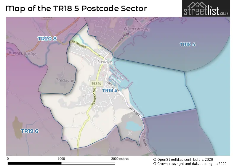
The TR18 5 Postcode shares a border with TR18 4 (PENZANCE, Tredarvah), TR19 6 (St. Buryan, Mousehole, St. Levan) and TR20 8 (Long Rock, Ludgvan, Crowlas).
The sector is within the post town of PENZANCE.
TR18 5 is a postcode sector within the TR18 postcode district which is within the TR Truro postcode area.
The Royal Mail delivery office for the TR18 5 postal sector is the Penzance Delivery Office.
The area of the TR18 5 postcode sector is 0.85 square miles which is 2.21 square kilometres or 546.48 square acres.

Map of the TR18 5 Postcode Sector
Explore the TR18 5 postcode sector by using our free interactive map.
| T | R | 1 | 8 | - | 5 | X | X |
| T | R | 1 | 8 | Space | 5 | Letter | Letter |
Official List of Streets
Newlyn (92 Streets)
Unofficial Streets or Alternative Spellings
Schools and Places of Education Within the TR18 5 Postcode Sector
Newlyn School
Academy converter
Carne Road, Penzance, Cornwall, TR18 5QA
Head: Ms Lauren Connolly
Ofsted Rating: Good
Inspection: 2023-06-15 (353 days ago)
Website: Visit Newlyn School Website
Phone: 01736363509
Number of Pupils: 129
House Prices in the TR18 5 Postcode Sector
| Type of Property | 2018 Average | 2018 Sales | 2017 Average | 2017 Sales | 2016 Average | 2016 Sales | 2015 Average | 2015 Sales |
|---|---|---|---|---|---|---|---|---|
| Detached | £329,353 | 17 | £294,896 | 23 | £339,123 | 20 | £315,825 | 20 |
| Semi-Detached | £231,675 | 20 | £203,438 | 16 | £194,818 | 14 | £229,222 | 9 |
| Terraced | £203,528 | 35 | £193,335 | 37 | £172,552 | 42 | £166,754 | 46 |
| Flats | £149,625 | 4 | £162,700 | 5 | £187,000 | 2 | £145,625 | 4 |
Important Postcodes TR18 5 in the Postcode Sector
TR18 5QA is the postcode for Newlyn School, Carne Road, and Newlyn School, Carne Road, Newlyn
| The TR18 5 Sector is within these Local Authorities |
|
|---|---|
| The TR18 5 Sector is within these Counties |
|
| The TR18 5 Sector is within these Water Company Areas |
|