The TS13 4 postcode sector is within the county of North Yorkshire.
Did you know? According to the 2021 Census, the TS13 4 postcode sector is home to a bustling 7,823 residents!
Given that each sector allows for 400 unique postcode combinations. Letters C, I, K, M, O and V are not allowed in the last two letters of a postcode. With 269 postcodes already in use, this leaves 131 units available.
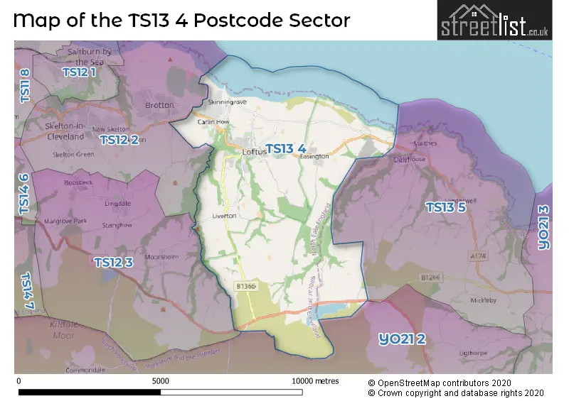
The largest settlement in the TS13 4 postal code is Loftus followed by Easington, and Carlin How.
The TS13 4 Postcode shares a border with TS13 5 (Staithes, Hinderwell, Runswick), TS12 2 (Skelton-in-Cleveland, Brotton), TS12 3 (Lingdale, Boosbeck, Moorsholm) and YO21 2 (Glaisdale, Danby, Castleton).
The sector is within the post town of SALTBURN-BY-THE-SEA.
TS13 4 is a postcode sector within the TS13 postcode district which is within the TS Teeside postcode area.
The Royal Mail delivery office for the TS13 4 postal sector is the Skelton-in-cleveland Delivery Office.
The area of the TS13 4 postcode sector is 17.54 square miles which is 45.43 square kilometres or 11,225.27 square acres.

Map of the TS13 4 Postcode Sector
Explore the TS13 4 postcode sector by using our free interactive map.
| T | S | 1 | 3 | - | 4 | X | X |
| T | S | 1 | 3 | Space | 4 | Letter | Letter |
Official List of Streets
Easington (19 Streets)
Skinningrove (16 Streets)
Loftus (83 Streets)
Carlin How (22 Streets)
Liverton (22 Streets)
Scaling (2 Streets)
SALTBURN-BY-THE-SEA (1 Streets)
Unofficial Streets or Alternative Spellings
Loftus
CO-OPERATIVE TERRACE VICTORIA TERRACESALTBURN-BY-THE-SEA
THE YARDDanby
WEST LANEBrotton
KILTON LANESchools and Places of Education Within the TS13 4 Postcode Sector
Hummersea Primary School
Community school
Westfield Way, Saltburn-by-the-Sea, North Yorkshire, TS13 4XD
Head: Mrs Claire Grainger
Ofsted Rating: Outstanding
Inspection: 2015-07-02 (3248 days ago)
Website: Visit Hummersea Primary School Website
Phone: 01287641781
Number of Pupils: 315
Saint Joseph's Catholic Primary School, A Catholic Voluntary Academy
Academy converter
Rosecroft Lane, Saltburn-by-the-Sea, North Yorkshire, TS13 4PZ
Head: Mr Simon Geaves
Ofsted Rating: Outstanding
Inspection: 2017-09-28 (2429 days ago)
Website: Visit Saint Joseph's Catholic Primary School, A Catholic Voluntary Academy Website
Phone: 01287640613
Number of Pupils: 177
Whitecliffe Academy
Academy converter
Mill Lane, Saltburn-By-The-Sea, North Yorkshire, TS13 4AD
Head: Mr Rob Cole
Ofsted Rating: Good
Inspection: 2019-07-11 (1778 days ago)
Website: Visit Whitecliffe Academy Website
Phone: 01287640414
Number of Pupils: 113
House Prices in the TS13 4 Postcode Sector
| Type of Property | 2018 Average | 2018 Sales | 2017 Average | 2017 Sales | 2016 Average | 2016 Sales | 2015 Average | 2015 Sales |
|---|---|---|---|---|---|---|---|---|
| Detached | £189,121 | 14 | £194,821 | 14 | £148,264 | 10 | £178,250 | 8 |
| Semi-Detached | £112,143 | 21 | £114,592 | 24 | £120,406 | 16 | £105,841 | 22 |
| Terraced | £62,281 | 70 | £60,535 | 80 | £61,306 | 72 | £71,858 | 50 |
| Flats | £33,750 | 2 | £53,250 | 2 | £35,500 | 2 | £63,000 | 2 |
Important Postcodes TS13 4 in the Postcode Sector
TS13 4AD is the postcode for Whitecliffe Primary Academy, Carlin How
TS13 4HG is the postcode for Loftus Town Hall, High Street
TS13 4PR is the postcode for Youth Club, Duncan Place
TS13 4PZ is the postcode for St Joseph's VA Primary Academy, Rosecroft Lane, and St Joseph's VA Primary Academy, Rosecroft Lane, Loftus
TS13 4RF is the postcode for Jobcentre Plus, 52-53 West Road
TS13 4RL is the postcode for BLUE SITE, Handale Primary School, West Park Avenue, and Handale Primary School, West Park Avenue
TS13 4RS is the postcode for Loftus Leisure Centre, Deepdale Road, Loftus, and Loftus Leisure Centre, Deepdale Road
TS13 4SW is the postcode for Cleveland Fire Brigade, Fire Station, Coronation Road
TS13 4XD is the postcode for Hummersea Primary School, Westfield Way
| The TS13 4 Sector is within these Local Authorities |
|
|---|---|
| The TS13 4 Sector is within these Counties |
|
| The TS13 4 Sector is within these Water Company Areas |
|