The TS13 5 postcode sector is within the county of North Yorkshire.
Did you know? According to the 2021 Census, the TS13 5 postcode sector is home to a bustling 2,134 residents!
Given that each sector allows for 400 unique postcode combinations. Letters C, I, K, M, O and V are not allowed in the last two letters of a postcode. With 121 postcodes already in use, this leaves 279 units available.
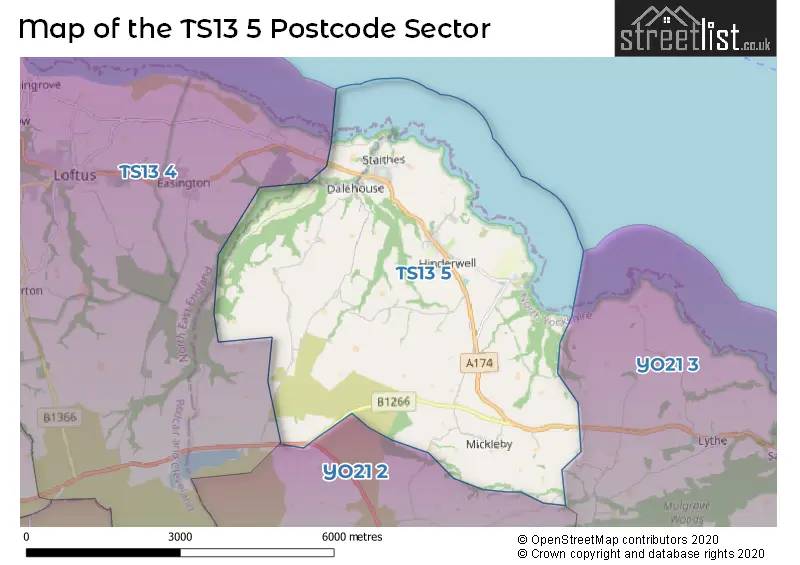
The largest settlement in the TS13 5 postal code is Staithes followed by Hinderwell, and Runswick.
The TS13 5 Postcode shares a border with TS13 4 (Loftus, Easington, Carlin How), YO21 2 (Glaisdale, Danby, Castleton) and YO21 3 (WHITBY, Sandsend, Lythe).
The sector is within the post town of SALTBURN-BY-THE-SEA.
TS13 5 is a postcode sector within the TS13 postcode district which is within the TS Teeside postcode area.
The Royal Mail delivery office for the TS13 5 postal sector is the Skelton-in-cleveland Delivery Office.
The area of the TS13 5 postcode sector is 12.75 square miles which is 33.02 square kilometres or 8,158.58 square acres.


Map of the TS13 5 Postcode Sector
Explore the TS13 5 postcode sector by using our free interactive map.
| T | S | 1 | 3 | - | 5 | X | X |
| T | S | 1 | 3 | Space | 5 | Letter | Letter |
Official List of Streets
Staithes (34 Streets)
Hinderwell (14 Streets)
Runswick (6 Streets)
Borrowby (1 Streets)
Port Mulgrave (5 Streets)
Ellerby (1 Streets)
Unofficial Streets or Alternative Spellings
West Barnby
SCAR LANEStaithes
BOATHOUSE YARDLythe
HIGH STREETScaling
RIDGE LANEEasington
WHITBY ROADUgthorpe
BROOM HOUSE LANESchools and Places of Education Within the TS13 5 Postcode Sector
Staithes, Seton Community Primary School
Community school
Seaton Close, Saltburn-by-the-Sea, North Yorkshire, TS13 5AU
Head: Mrs Helen Isaac
Ofsted Rating: Good
Inspection: 2018-09-19 (2087 days ago)
Website: Visit Staithes, Seton Community Primary School Website
Phone: 01947840257
Number of Pupils: 78
House Prices in the TS13 5 Postcode Sector
| Type of Property | 2018 Average | 2018 Sales | 2017 Average | 2017 Sales | 2016 Average | 2016 Sales | 2015 Average | 2015 Sales |
|---|---|---|---|---|---|---|---|---|
| Detached | £317,677 | 7 | £283,119 | 8 | £189,583 | 6 | £240,864 | 11 |
| Semi-Detached | £158,367 | 15 | £144,091 | 11 | £193,375 | 12 | £160,500 | 11 |
| Terraced | £219,215 | 23 | £195,227 | 15 | £170,870 | 27 | £174,128 | 31 |
| Flats | £173,667 | 3 | £70,000 | 1 | £140,000 | 1 | £147,500 | 2 |
Important Postcodes TS13 5 in the Postcode Sector
TS13 5AU is the postcode for Seton Community Primary school, Seaton Close, Staithes, and Seton Community Primary School, Seaton Close
TS13 5AY is the postcode for Staithes Surgery, Seaton Crescent
TS13 5HA is the postcode for Oakridge Cp School, Coronation Avenue, Hinderwell, and Oakridge Cp School, Coronation Avenue
| The TS13 5 Sector is within these Local Authorities |
|
|---|---|
| The TS13 5 Sector is within these Counties |
|
| The TS13 5 Sector is within these Water Company Areas |
|