The TS4 2 postcode sector is within the county of North Yorkshire.
Did you know? According to the 2021 Census, the TS4 2 postcode sector is home to a bustling 9,817 residents!
Given that each sector allows for 400 unique postcode combinations. Letters C, I, K, M, O and V are not allowed in the last two letters of a postcode. With 239 postcodes already in use, this leaves 161 units available.
The TS4 2 postal code covers the settlement of MIDDLESBROUGH.
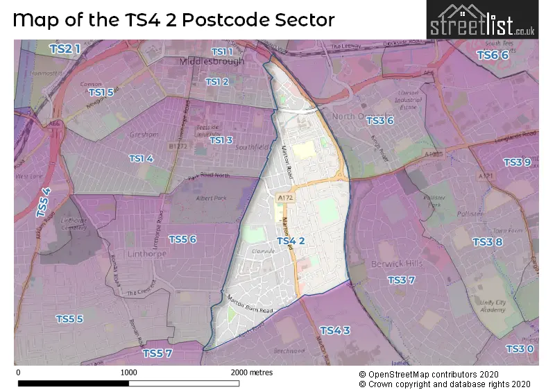
The TS4 2 Postcode shares a border with TS1 2 (MIDDLESBROUGH), TS1 3 (MIDDLESBROUGH), TS3 6 (MIDDLESBROUGH, North Ormesby), TS3 7 (MIDDLESBROUGH), TS5 6 (MIDDLESBROUGH), TS4 3 (MIDDLESBROUGH) and TS5 7 (MIDDLESBROUGH).
The sector is within the post town of MIDDLESBROUGH.
TS4 2 is a postcode sector within the TS4 postcode district which is within the TS Teeside postcode area.
The Royal Mail delivery office for the TS4 2 postal sector is the Middlesbrough Delivery Office.
The area of the TS4 2 postcode sector is 0.67 square miles which is 1.73 square kilometres or 427.57 square acres.

Map of the TS4 2 Postcode Sector
Explore the TS4 2 postcode sector by using our free interactive map.
| T | S | 4 | - | 2 | X | X |
| T | S | 4 | Space | 2 | Letter | Letter |
Official List of Streets
MIDDLESBROUGH (125 Streets)
Unofficial Streets or Alternative Spellings
MIDDLESBROUGH
BEECH GROVE ROAD CARGO FLEET ROAD CROYDON ROAD CUMBERLAND ROAD EASTBOURNE ROAD EMERSON AVENUE FALMOUTH STREET GRANGE ROAD HOLLYHURST AVENUE NEWLANDS ROAD PARK LANE PARK ROAD NORTH SOUTHFIELD ROAD STAMFORD STREET SYCAMORE ROAD TALBOT STREET VICTORIA ROAD WATERLOO ROAD YORK ROAD BELLE VUE ROUNDABOUT BYRNESIDE AVENUE CASTLE WAY CRAGGS STREET CROFTON AVENUE CROSTHWAITE AVENUE HAWTHORNE AVENUE HEADINGHAM CLOSE HILLSIDE AVENUE HOLYROOD CLOSE HORSEFIELD STREET KILDALE ROAD LANGTON CLOSE MAPLE AVENUE MARTON ROAD INTERCHANGE MEADOWFIELD AVENUE NEWLANDS ROAD OLD COVENT GARDENS ROSECROFT AVENUE STONE STREET SUNNYSIDE AVENUE THE VALE WOODSIDE STREETSchools and Places of Education Within the TS4 2 Postcode Sector
St Joseph's Catholic Primary School
Academy converter
Marton Road, Middlesbrough, , TS4 2NT
Head: Mrs Jill Manders
Ofsted Rating: Good
Inspection: 2019-05-09 (1841 days ago)
Website: Visit St Joseph's Catholic Primary School Website
Phone: 01642819252
Number of Pupils: 376
House Prices in the TS4 2 Postcode Sector
| Type of Property | 2018 Average | 2018 Sales | 2017 Average | 2017 Sales | 2016 Average | 2016 Sales | 2015 Average | 2015 Sales |
|---|---|---|---|---|---|---|---|---|
| Detached | £181,126 | 23 | £180,897 | 15 | £171,150 | 31 | £167,425 | 10 |
| Semi-Detached | £119,987 | 51 | £116,623 | 45 | £112,758 | 49 | £104,209 | 43 |
| Terraced | £74,288 | 41 | £76,082 | 19 | £75,351 | 36 | £76,853 | 30 |
| Flats | £65,317 | 3 | £47,250 | 2 | £111,650 | 6 | £46,115 | 6 |
Important Postcodes TS4 2 in the Postcode Sector
TS4 2AF is the postcode for Thirteen Group, Rivers House
TS4 2DS is the postcode for Breckon Hill Primary School, Breckon Hill Road
TS4 2NT is the postcode for St. Josephs RC Primary School, Marton Road
TS4 2QT is the postcode for The Orchard, Lansdowne Road
TS4 2QX is the postcode for Lothian Road Day Centre, 90-92 Lothian Road
TS4 2RF is the postcode for Marton Grove Primary School, Lambton Road
TS4 2RP is the postcode for Grove Hill Youth & Community, Bishopton Road
| The TS4 2 Sector is within these Local Authorities |
|
|---|---|
| The TS4 2 Sector is within these Counties |
|
| The TS4 2 Sector is within these Water Company Areas |
|