The TS6 0 postcode sector is within the county of North Yorkshire.
Did you know? According to the 2021 Census, the TS6 0 postcode sector is home to a bustling 10,776 residents!
Given that each sector allows for 400 unique postcode combinations. Letters C, I, K, M, O and V are not allowed in the last two letters of a postcode. With 252 postcodes already in use, this leaves 148 units available.
The largest settlement in the TS6 0 postal code is MIDDLESBROUGH followed by Normanby, and Eston.
The TS6 0 Postcode shares a border with TS3 0 (MIDDLESBROUGH), TS3 9 (MIDDLESBROUGH), TS6 9 (MIDDLESBROUGH, Eston, Normanby), TS7 9 (Ormesby), TS14 6 (GUISBOROUGH, Dunsdale), TS6 6 (MIDDLESBROUGH, South Bank, Skippers Lane Industrial Estate) and TS7 0 (Nunthorpe).
The sector is within the post town of MIDDLESBROUGH.
TS6 0 is a postcode sector within the TS6 postcode district which is within the TS Teeside postcode area.
The Royal Mail delivery office for the TS6 0 postal sector is the South Bank Delivery Office.
The area of the TS6 0 postcode sector is 2.13 square miles which is 5.51 square kilometres or 1,362.56 square acres.
The TS6 0 postcode sector is crossed by the A174 Major A road.

Map of the TS6 0 Postcode Sector
Explore the TS6 0 postcode sector by using our free interactive map.
| T | S | 6 | - | 0 | X | X |
| T | S | 6 | Space | 0 | Letter | Letter |
Official List of Streets
MIDDLESBROUGH (116 Streets)
Normanby (30 Streets)
Eston (9 Streets)
South Bank (2 Streets)
Unofficial Streets or Alternative Spellings
MIDDLESBROUGH
OCCUPATION ROAD ORCHARD GROVEEston
TRUNK ROAD CRABTREE WALK FALL WAY PARRINGTON STREET THE BEECHES THE PARKWAY WOOLGARTHSouth Bank
NORMANBY ROADNunthorpe
FLATTS LANEOrmesby
NORMANBY ROAD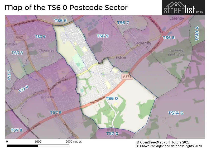
House Prices in the TS6 0 Postcode Sector
| Type of Property | 2018 Average | 2018 Sales | 2017 Average | 2017 Sales | 2016 Average | 2016 Sales | 2015 Average | 2015 Sales |
|---|---|---|---|---|---|---|---|---|
| Detached | £224,303 | 18 | £204,798 | 49 | £199,931 | 36 | £187,717 | 42 |
| Semi-Detached | £125,331 | 92 | £121,630 | 105 | £127,247 | 125 | £126,627 | 82 |
| Terraced | £78,103 | 34 | £75,436 | 32 | £74,729 | 24 | £77,241 | 28 |
| Flats | £52,833 | 3 | £45,333 | 3 | £62,083 | 3 | £58,500 | 3 |
Important Postcodes TS6 0 in the Postcode Sector
TS6 0BZ is the postcode for Teesville Primary School, Lime Road
TS6 0DD is the postcode for Teesville Infant School, The Avenue, and Archway, Learning Lane
TS6 0EE is the postcode for Ravensworth Junior School, Ravensworth Avenue, and Teesville Primary School, Ravensworth Avenue
TS6 0HA is the postcode for MANOR HOUSE SURGERY, Dr McKeown & Partners, Braidwood Road
TS6 0NP is the postcode for WEST BUILDING, Normanby Primary Academy, Flatts Lane, Bankfield Court Hospital, Flatts Lane, EAST BUILDING, Normanby Primary Academy, Flatts Lane, Tees, Esk and Wear Valleys NHS Trust, Bankfields Court Stephen Knox, and Normanby Primary Academy, Flatts Lane
TS6 0RZ is the postcode for WEST BUILDING, Bankfields Primary School, Mansfield Road, and EAST BUILDING, Bankfields Primary School, Mansfield Road
TS6 0SZ is the postcode for Flatts Lane Centre, Flatts Lane, Tees, Esk & Wear Valleys NHS Foundation Trust, Flatts Lane Centre, Flatts Lane, and Tees, Esk & Wear Valleys NHS Foundation Trust, Flatts Lane Centre
| The TS6 0 Sector is within these Local Authorities |
|
|---|---|
| The TS6 0 Sector is within these Counties |
|
| The TS6 0 Sector is within these Water Company Areas |
|