The TW10 5 postcode sector is within the county of Greater London.
Did you know? According to the 2021 Census, the TW10 5 postcode sector is home to a bustling 3,430 residents!
Given that each sector allows for 400 unique postcode combinations. Letters C, I, K, M, O and V are not allowed in the last two letters of a postcode. With 91 postcodes already in use, this leaves 309 units available.
The largest settlement in the TW10 5 postal code is RICHMOND followed by HAM , and EAST SHEEN .
The TW10 5 Postcode shares a border with SW15 5 (LONDON , BARNES ), SW14 7 (EAST SHEEN , MORTLAKE ), SW14 8 (EAST SHEEN , MORTLAKE ), SW15 3 (LONDON , KINGSTON VALE ), SW15 4 (LONDON ), TW10 6 (RICHMOND ), TW9 1 (RICHMOND ), TW9 4 (KEW , RICHMOND ), TW10 7 (HAM , PETERSHAM ), KT2 5 (KINGSTON UPON THAMES , HAM COMMON ) and KT2 7 (KINGSTON UPON THAMES ).
The sector is within the post town of RICHMOND.
TW10 5 is a postcode sector within the TW10 postcode district which is within the TW Twickenham postcode area.
The Royal Mail delivery office for the TW10 5 postal sector is the Richmond (tw).
The area of the TW10 5 postcode sector is 3.13 square miles which is 8.12 square kilometres or 2,005.35 square acres.
Waterways within the TW10 5 postcode sector include the Beverly Brook.

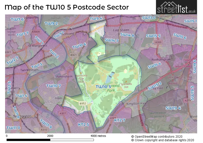
Map of the TW10 5 Postcode Sector
Explore the TW10 5 postcode sector by using our free interactive map.
| T | W | 1 | 0 | - | 5 | X | X |
| T | W | 1 | 0 | Space | 5 | Letter | Letter |
Official List of Streets
RICHMOND (24 Streets)
Unofficial Streets or Alternative Spellings
RICHMOND
HAM COMMON MANOR ROADKINGSTON UPON THAMES
BARNFIELD GARDENS COWPER ROAD LATCHMERE LANEKINGSTON UPON THAMES,
UPPER HAM ROADRichmond upon Thames
CHRISTCHURCH ROAD CLIFFORD AVENUE LANGDALE CLOSE STANLEY ROAD UPPER RICHMOND ROAD WESTSchools and Places of Education Within the TW10 5 Postcode Sector
Holy Trinity Church of England Primary School
Voluntary aided school
Carrington Road, Richmond, Surrey, TW10 5AA
Head: Mrs Alison Bateman
Ofsted Rating: Outstanding
Inspection: 2015-07-09 (3241 days ago)
Website: Visit Holy Trinity Church of England Primary School Website
Phone: 02089402730
Number of Pupils: 412
House Prices in the TW10 5 Postcode Sector
| Type of Property | 2018 Average | 2018 Sales | 2017 Average | 2017 Sales | 2016 Average | 2016 Sales | 2015 Average | 2015 Sales |
|---|---|---|---|---|---|---|---|---|
| Detached | £2,113,125 | 8 | £2,246,667 | 3 | £1,881,250 | 4 | £3,064,167 | 6 |
| Semi-Detached | £1,392,278 | 9 | £1,044,750 | 16 | £1,268,867 | 9 | £1,167,045 | 11 |
| Terraced | £972,842 | 12 | £749,447 | 7 | £1,715,288 | 4 | £835,000 | 3 |
| Flats | £519,878 | 27 | £495,476 | 23 | £513,909 | 34 | £463,789 | 32 |
Important Postcodes TW10 5 in the Postcode Sector
TW10 5AA is the postcode for A - MAIN SCHOOL HOLY TRINITY CE PRIMARY SCHOOL, Holy Trinity CE Primary School, Carrington Road, Holy Trinity CE Primary and Nursery School, Carrington Rd, and Holy Trinity CE Primary School, Carrington Road
TW10 5HH is the postcode for Latchmere House, Church Road
| The TW10 5 Sector is within these Local Authorities |
|
|---|---|
| The TW10 5 Sector is within these Counties |
|
| The TW10 5 Sector is within these Water Company Areas |
|