The TW3 4 postcode sector is within the county of Greater London.
Did you know? According to the 2021 Census, the TW3 4 postcode sector is home to a bustling 10,334 residents!
Given that each sector allows for 400 unique postcode combinations. Letters C, I, K, M, O and V are not allowed in the last two letters of a postcode. With 133 postcodes already in use, this leaves 267 units available.
The largest settlements in the TW3 4 postal code are HOUNSLOW and ISLEWORTH .
The TW3 4 Postcode shares a border with TW3 3 (HOUNSLOW , WHITTON ), TW4 7 (HOUNSLOW ), TW5 0 (HOUNSLOW , BRENTFORD , ISLEWORTH ), TW7 4 (ISLEWORTH , BRENTFORD ) and TW3 1 (HOUNSLOW , ISLEWORTH ).
The sector is within the post town of HOUNSLOW.
TW3 4 is a postcode sector within the TW3 postcode district which is within the TW Twickenham postcode area.
The Royal Mail delivery office for the TW3 4 postal sector is the Hounslow Delivery Office.
The area of the TW3 4 postcode sector is 0.51 square miles which is 1.31 square kilometres or 323.58 square acres.

Map of the TW3 4 Postcode Sector
Explore the TW3 4 postcode sector by using our free interactive map.
| T | W | 3 | - | 4 | X | X |
| T | W | 3 | Space | 4 | Letter | Letter |
Official List of Streets
HOUNSLOW (59 Streets)
Unofficial Streets or Alternative Spellings
HOUNSLOW
AMBASSADOR CLOSE POOLE COURT ROAD RENFREW ROADHOUNSLOW,
JERSEY ROAD SPRING GROVE ROAD CIVIC CORNER HESTON WAY ISELWORTH GREEN ISEWORTH STREET LAMPTON WALK THE SHORT HEDGESHammersmith and Fulham
GREAT WEST ROAD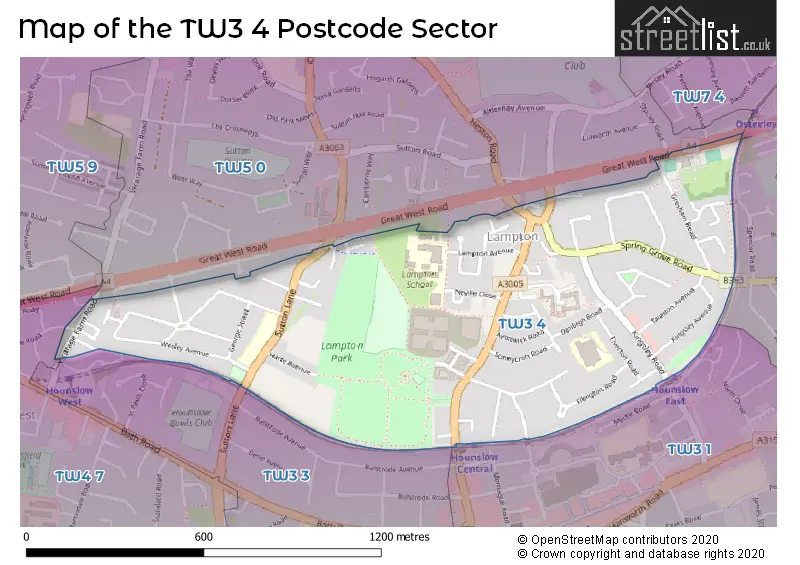
House Prices in the TW3 4 Postcode Sector
| Type of Property | 2018 Average | 2018 Sales | 2017 Average | 2017 Sales | 2016 Average | 2016 Sales | 2015 Average | 2015 Sales |
|---|---|---|---|---|---|---|---|---|
| Detached | £0 | 0 | £452,500 | 2 | £0 | 0 | £409,667 | 3 |
| Semi-Detached | £470,667 | 9 | £452,692 | 13 | £453,511 | 18 | £416,271 | 33 |
| Terraced | £441,797 | 17 | £396,375 | 8 | £442,441 | 11 | £368,175 | 14 |
| Flats | £254,529 | 17 | £272,596 | 13 | £263,000 | 17 | £222,600 | 14 |
Important Postcodes TW3 4 in the Postcode Sector
TW3 4DN is the postcode for London Borough of Hounslow, Civic Centre, Lampton Road
TW3 4DU is the postcode for Alexandra Junior School, Denbigh Road, Alexandra Primary School, Denbigh Road, and Alexandra Nursery & Infant School, Denbigh Road
TW3 4DW is the postcode for HOUNSLOW REGISTER OFFICE, London Borough of Hounslow, 88 Lampton Road
TW3 4EP is the postcode for LAMPTON SCHOOL, LAMPTON AVENUE, HOUNSLOW, SIXTH FORM CENTRE, Lampton School, Lampton Avenue, SPRING GROVE - PEARS BUILDING, Lampton School, Lampton Avenue, Lampton Sports Centre, Lampton Avenue, and MAIN BUILDING, Lampton School, Lampton Avenue
TW3 4JG is the postcode for Lampton Childrens Centre, Neville Close
TW3 4LB is the postcode for Wellington Primary School, Sutton Lane, and NURSERY, Wellington Primary School, Sutton Lane
| The TW3 4 Sector is within these Local Authorities |
|
|---|---|
| The TW3 4 Sector is within these Counties |
|
| The TW3 4 Sector is within these Water Company Areas |
|