The TW5 9 postcode sector is within the county of Greater London.
Did you know? According to the 2021 Census, the TW5 9 postcode sector is home to a bustling 17,647 residents!
Given that each sector allows for 400 unique postcode combinations. Letters C, I, K, M, O and V are not allowed in the last two letters of a postcode. With 215 postcodes already in use, this leaves 185 units available.
The largest settlement in the TW5 9 postal code is HOUNSLOW followed by CRANFORD , and BRENTFORD .
The TW5 9 Postcode shares a border with TW4 6 (HOUNSLOW ), TW4 7 (HOUNSLOW ), TW5 0 (HOUNSLOW , BRENTFORD , ISLEWORTH ), TW6 2 (LONDON HEATHROW AIRPORT , HEATHROW ), UB3 4 (HAYES ), UB3 5 (HAYES , HARLINGTON , HEATHROW ) and UB2 5 (SOUTHALL ).
The sector is within the post town of HOUNSLOW.
TW5 9 is a postcode sector within the TW5 postcode district which is within the TW Twickenham postcode area.
The Royal Mail delivery office for the TW5 9 postal sector is the Hounslow Delivery Office.
The area of the TW5 9 postcode sector is 1.74 square miles which is 4.52 square kilometres or 1,116.74 square acres.
The TW5 9 postcode sector is crossed by the M4 motorway.
The TW5 9 postcode sector is crossed by the A312 Major A road.
Waterways within the TW5 9 postcode sector include the River Crane.

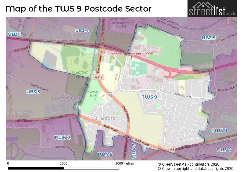
Map of the TW5 9 Postcode Sector
Explore the TW5 9 postcode sector by using our free interactive map.
| T | W | 5 | - | 9 | X | X |
| T | W | 5 | Space | 9 | Letter | Letter |
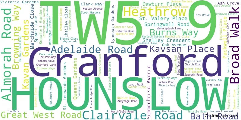
Official List of Streets
HOUNSLOW (80 Streets)
Unofficial Streets or Alternative Spellings
Hammersmith and Fulham
GREAT WEST ROADHOUNSLOW
BASILDENE ROAD BERKELEY AVENUE BURNHAM GARDENS DAWBURN PLACE ORCHARD AVENUE RECTORY ROAD TRAVELLERS WAY VICARAGE FARM ROAD WOODFIELD ROADHOUNSLOW,
NORTH HYDE LANEBedfont
GREAT SOUTH WEST ROADSOUTHALL
CONVENT WAYHarlington
CRANFORD LANE HIGH STREETColnbrook
BATH ROADWeather Forecast for TW5 9
Press Button to Show Forecast for Hayes
| Time Period | Icon | Description | Temperature | Rain Probability | Wind |
|---|---|---|---|---|---|
| 12:00 to 15:00 | Cloudy | 14.0°C (feels like 11.0°C) | 4.00% | SSW 16 mph | |
| 15:00 to 18:00 | Cloudy | 15.0°C (feels like 11.0°C) | 3.00% | SSW 16 mph | |
| 18:00 to 21:00 | Sunny day | 14.0°C (feels like 11.0°C) | 0.00% | SSW 11 mph | |
| 21:00 to 00:00 | Clear night | 11.0°C (feels like 9.0°C) | 0.00% | SSE 7 mph |
Press Button to Show Forecast for Hayes
| Time Period | Icon | Description | Temperature | Rain Probability | Wind |
|---|---|---|---|---|---|
| 00:00 to 03:00 | Clear night | 9.0°C (feels like 8.0°C) | 0.00% | SSE 7 mph | |
| 03:00 to 06:00 | Clear night | 8.0°C (feels like 7.0°C) | 0.00% | SE 7 mph | |
| 06:00 to 09:00 | Sunny day | 9.0°C (feels like 7.0°C) | 0.00% | SE 4 mph | |
| 09:00 to 12:00 | Sunny day | 14.0°C (feels like 13.0°C) | 1.00% | SSE 9 mph | |
| 12:00 to 15:00 | Partly cloudy (day) | 17.0°C (feels like 14.0°C) | 3.00% | SSE 13 mph | |
| 15:00 to 18:00 | Partly cloudy (day) | 17.0°C (feels like 14.0°C) | 7.00% | SSE 11 mph | |
| 18:00 to 21:00 | Partly cloudy (day) | 15.0°C (feels like 14.0°C) | 7.00% | SSE 7 mph | |
| 21:00 to 00:00 | Partly cloudy (night) | 11.0°C (feels like 10.0°C) | 7.00% | SE 4 mph |
Press Button to Show Forecast for Hayes
| Time Period | Icon | Description | Temperature | Rain Probability | Wind |
|---|---|---|---|---|---|
| 00:00 to 03:00 | Cloudy | 11.0°C (feels like 10.0°C) | 9.00% | SE 4 mph | |
| 03:00 to 06:00 | Cloudy | 10.0°C (feels like 9.0°C) | 8.00% | S 4 mph | |
| 06:00 to 09:00 | Cloudy | 10.0°C (feels like 9.0°C) | 9.00% | N 2 mph | |
| 09:00 to 12:00 | Cloudy | 13.0°C (feels like 12.0°C) | 10.00% | NNW 2 mph | |
| 12:00 to 15:00 | Cloudy | 15.0°C (feels like 15.0°C) | 13.00% | E 2 mph | |
| 15:00 to 18:00 | Cloudy | 16.0°C (feels like 15.0°C) | 13.00% | NE 4 mph | |
| 18:00 to 21:00 | Cloudy | 15.0°C (feels like 14.0°C) | 15.00% | NE 4 mph | |
| 21:00 to 00:00 | Cloudy | 13.0°C (feels like 12.0°C) | 19.00% | N 7 mph |
Press Button to Show Forecast for Hayes
| Time Period | Icon | Description | Temperature | Rain Probability | Wind |
|---|---|---|---|---|---|
| 00:00 to 03:00 | Light rain shower (night) | 12.0°C (feels like 11.0°C) | 39.00% | N 4 mph | |
| 03:00 to 06:00 | Light rain | 11.0°C (feels like 10.0°C) | 43.00% | NNW 4 mph | |
| 06:00 to 09:00 | Overcast | 11.0°C (feels like 10.0°C) | 17.00% | NW 7 mph | |
| 09:00 to 12:00 | Overcast | 13.0°C (feels like 12.0°C) | 16.00% | NW 7 mph | |
| 12:00 to 15:00 | Cloudy | 16.0°C (feels like 15.0°C) | 9.00% | NW 7 mph | |
| 15:00 to 18:00 | Partly cloudy (day) | 18.0°C (feels like 16.0°C) | 8.00% | NW 9 mph | |
| 18:00 to 21:00 | Cloudy | 17.0°C (feels like 16.0°C) | 10.00% | NNW 9 mph | |
| 21:00 to 00:00 | Partly cloudy (night) | 14.0°C (feels like 13.0°C) | 5.00% | NNW 9 mph |
Schools and Places of Education Within the TW5 9 Postcode Sector
Cranford Community College
Academy converter
High Street, Hounslow, Middlesex, TW5 9PD
Head: Mr Robert Ind & Ms Rita Berndt
Ofsted Rating: Good
Inspection: 2022-03-10 (781 days ago)
Website: Visit Cranford Community College Website
Phone: 02088972001
Number of Pupils: 1491
The Cedars Primary School
Community special school
High Street, Hounslow, Middlesex, TW5 9RU
Head: Mr Gavin Winters
Ofsted Rating: Outstanding
Inspection: 2023-01-11 (474 days ago)
Website: Visit The Cedars Primary School Website
Phone: 02082300015
Number of Pupils: 62
Unique Academy
Other independent school
Ground Floor, Hounslow, , TW5 9WA
Head: Mrs Hawwa Mbombo
Ofsted Rating: Good
Inspection: 2022-05-27 (703 days ago)
Website: Visit Unique Academy Website
Phone: 02080045481
Number of Pupils: 44
House Prices in the TW5 9 Postcode Sector
| Type of Property | 2018 Average | 2018 Sales | 2017 Average | 2017 Sales | 2016 Average | 2016 Sales | 2015 Average | 2015 Sales |
|---|---|---|---|---|---|---|---|---|
| Detached | £557,500 | 3 | £1,146,650 | 3 | £592,000 | 5 | £751,000 | 3 |
| Semi-Detached | £472,095 | 37 | £445,517 | 35 | £423,902 | 32 | £423,284 | 35 |
| Terraced | £420,041 | 22 | £397,310 | 29 | £356,623 | 29 | £334,242 | 37 |
| Flats | £264,864 | 11 | £220,679 | 19 | £237,367 | 19 | £249,145 | 59 |
Important Postcodes TW5 9 in the Postcode Sector
TW5 9BJ is the postcode for 2 Shelley Crescent
TW5 9EF is the postcode for Springwell School (Lower School /EYFS/KS1), Speart Lane, Heston, and Springwell Infant & Nursery School, Speart Lane
TW5 9EP is the postcode for The Berkeley Centre, 27, Cranford Lane
TW5 9ER is the postcode for Heston Health Clinic, 25 Cranford Lane
TW5 9HQ is the postcode for Berkeley Academy, Cranford Lane
TW5 9PD is the postcode for FRONT BUILDING, Cranford Community College, High Street, THE SUPER DOME, Cranford Community College, High Street, REAR BUILDING, Cranford Community College, High Street, and STUDY CENTRE 1, Cranford Community College, High Street
TW5 9PQ is the postcode for MAIN BUILDING, Concorde Centre, Crane Lodge Road
TW5 9QX is the postcode for Meadowbank, 680 Bath Road
TW5 9RU is the postcode for The Cedars Primary School, High Street, The Cedars Primary School, High Street, Cranford, and THE CEDARS SCHOOL HOUSE, THE CEDARS PRIMARY SCHOOL, HIGH STREET
TW5 9TL is the postcode for Cranford Library, Bath Road, and London Borough of Hounslow, Cranford Library, Bath Road
| The TW5 9 Sector is within these Local Authorities |
|
|---|---|
| The TW5 9 Sector is within these Counties |
|
| The TW5 9 Sector is within these Water Company Areas |
|