The WA16 0 postcode sector is within the county of Cheshire.
Did you know? According to the 2021 Census, the WA16 0 postcode sector is home to a bustling 5,890 residents!
Given that each sector allows for 400 unique postcode combinations. Letters C, I, K, M, O and V are not allowed in the last two letters of a postcode. With 254 postcodes already in use, this leaves 146 units available.
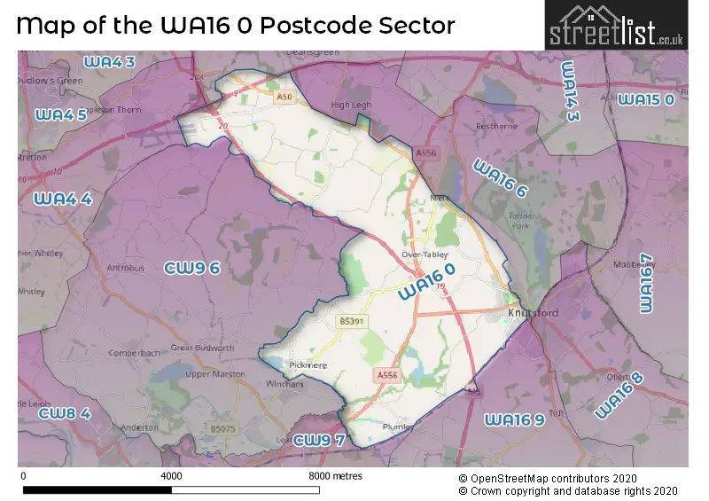
The largest settlement in the WA16 0 postal code is KNUTSFORD followed by Pickmere, and High Legh.
The WA16 0 Postcode shares a border with WA13 0 (LYMM), WA16 6 (KNUTSFORD, High Legh, Mere), CW9 6 (Wincham, Antrobus, Comberbach), CW9 7 (NORTHWICH, Rudheath, Lostock Gralam), WA4 4 (Appleton Thorn, Daresbury, Dutton) and WA16 9 (KNUTSFORD, Allostock, Lower Peover).
The sector is within the post town of KNUTSFORD.
WA16 0 is a postcode sector within the WA16 postcode district which is within the WA Warrington postcode area.
The Royal Mail delivery office for the WA16 0 postal sector is the Knutsford Delivery Office.
The area of the WA16 0 postcode sector is 16.16 square miles which is 41.86 square kilometres or 10,344.67 square acres.
The WA16 0 postcode sector is crossed by the M6 motorway.
The WA16 0 postcode sector is crossed by the A556 Major A road.
The WA16 0 postcode sector is crossed by the M56 motorway.

Map of the WA16 0 Postcode Sector
Explore the WA16 0 postcode sector by using our free interactive map.
| W | A | 1 | 6 | - | 0 | X | X |
| W | A | 1 | 6 | Space | 0 | Letter | Letter |
Official List of Streets
KNUTSFORD (47 Streets)
Plumley (14 Streets)
Pickmere (19 Streets)
Mere (10 Streets)
High Legh (16 Streets)
Tabley (9 Streets)
Unofficial Streets or Alternative Spellings
Bucklow Hill
CHESTER ROADKNUTSFORD
ALBERT STREET CANUTE PLACE CHURCH HILL GARDEN ROAD GREEN STREET MARCLIFF GROVE PRINCESS STREET QUEEN STREET VICTORIA STREET WILLOW GREEN WINDSOR WAYMere
CLAMHUNGER LANE MEREHEATH LANE MERESIDE ROAD BENTLEYHURST LANE BUCKLOWHILL LANE CHESTER ROAD ROUNDABOUT CROWLEY LANE DOBB LANE GREEN BRIDGE HIGH LEGH BR8 HILLTOP PARK HOLLOWOOD LANE HOOGREEN LANE HULSEHEATH LANE JETTY KNUTSFORD SERVICES NORTHBOUND KNUTSFORD SERVICES SOUTHBOUND LITTLE ROWLEY LANE MERE HEYS LANE MERE JUNCTION MERE VIEW MILLEY LANE MOSS BROW LANE OAK WOOD ROAD OLD HALL LANE EAST OLD HALL LANE WEST SPINK LANE SWAINS WALK TABLEY BROOK ROUNDABOUT TABLEY INTERCHANGE TABLEY JUNCTIONHigh Legh
CANDELAN WAY CRABTREE LANE WEST LANE WOODLANDS CRESCENT WRENSHOT LANEToft
TOFT ROADLower Peover
PLUMLEY MOOR ROADLostock Gralam
MANCHESTER ROADWincham
LINNARDS LANEAston By Budworth
CANN LANEWeather Forecast for WA16 0
Press Button to Show Forecast for Arley Hall
| Time Period | Icon | Description | Temperature | Rain Probability | Wind |
|---|---|---|---|---|---|
| 15:00 to 18:00 | Cloudy | 15.0°C (feels like 12.0°C) | 8.00% | S 13 mph | |
| 18:00 to 21:00 | Cloudy | 14.0°C (feels like 11.0°C) | 9.00% | S 13 mph | |
| 21:00 to 00:00 | Cloudy | 12.0°C (feels like 10.0°C) | 13.00% | SSE 7 mph |
Press Button to Show Forecast for Arley Hall
| Time Period | Icon | Description | Temperature | Rain Probability | Wind |
|---|---|---|---|---|---|
| 00:00 to 03:00 | Cloudy | 10.0°C (feels like 9.0°C) | 20.00% | SE 7 mph | |
| 03:00 to 06:00 | Cloudy | 10.0°C (feels like 9.0°C) | 11.00% | ESE 4 mph | |
| 06:00 to 09:00 | Cloudy | 11.0°C (feels like 10.0°C) | 4.00% | E 4 mph | |
| 09:00 to 12:00 | Cloudy | 14.0°C (feels like 13.0°C) | 7.00% | SE 4 mph | |
| 12:00 to 15:00 | Cloudy | 16.0°C (feels like 15.0°C) | 16.00% | E 7 mph | |
| 15:00 to 18:00 | Light rain | 16.0°C (feels like 15.0°C) | 51.00% | NE 4 mph | |
| 18:00 to 21:00 | Cloudy | 15.0°C (feels like 14.0°C) | 23.00% | NNE 7 mph | |
| 21:00 to 00:00 | Cloudy | 13.0°C (feels like 12.0°C) | 5.00% | NNE 7 mph |
Press Button to Show Forecast for Arley Hall
| Time Period | Icon | Description | Temperature | Rain Probability | Wind |
|---|---|---|---|---|---|
| 00:00 to 03:00 | Cloudy | 11.0°C (feels like 10.0°C) | 5.00% | NNE 9 mph | |
| 03:00 to 06:00 | Cloudy | 10.0°C (feels like 9.0°C) | 4.00% | NNE 9 mph | |
| 06:00 to 09:00 | Cloudy | 11.0°C (feels like 9.0°C) | 4.00% | NNE 9 mph | |
| 09:00 to 12:00 | Partly cloudy (day) | 14.0°C (feels like 12.0°C) | 1.00% | NE 11 mph | |
| 12:00 to 15:00 | Sunny day | 18.0°C (feels like 16.0°C) | 0.00% | NE 13 mph | |
| 15:00 to 18:00 | Sunny day | 19.0°C (feels like 17.0°C) | 1.00% | ENE 13 mph | |
| 18:00 to 21:00 | Sunny day | 17.0°C (feels like 15.0°C) | 2.00% | NE 11 mph | |
| 21:00 to 00:00 | Partly cloudy (night) | 12.0°C (feels like 11.0°C) | 0.00% | NE 9 mph |
Press Button to Show Forecast for Arley Hall
| Time Period | Icon | Description | Temperature | Rain Probability | Wind |
|---|---|---|---|---|---|
| 00:00 to 03:00 | Partly cloudy (night) | 11.0°C (feels like 10.0°C) | 1.00% | NE 7 mph | |
| 03:00 to 06:00 | Cloudy | 10.0°C (feels like 10.0°C) | 6.00% | NNE 4 mph | |
| 06:00 to 09:00 | Overcast | 11.0°C (feels like 10.0°C) | 10.00% | N 2 mph | |
| 09:00 to 12:00 | Cloudy | 13.0°C (feels like 12.0°C) | 10.00% | NW 4 mph | |
| 12:00 to 15:00 | Overcast | 15.0°C (feels like 14.0°C) | 13.00% | NNW 7 mph | |
| 15:00 to 18:00 | Overcast | 16.0°C (feels like 15.0°C) | 15.00% | NNW 7 mph | |
| 18:00 to 21:00 | Overcast | 15.0°C (feels like 14.0°C) | 17.00% | WNW 7 mph | |
| 21:00 to 00:00 | Overcast | 13.0°C (feels like 12.0°C) | 15.00% | WSW 7 mph |
Press Button to Show Forecast for Arley Hall
| Time Period | Icon | Description | Temperature | Rain Probability | Wind |
|---|---|---|---|---|---|
| 00:00 to 03:00 | Overcast | 12.0°C (feels like 11.0°C) | 13.00% | WSW 4 mph | |
| 03:00 to 06:00 | Overcast | 11.0°C (feels like 10.0°C) | 13.00% | SW 4 mph | |
| 06:00 to 09:00 | Cloudy | 11.0°C (feels like 10.0°C) | 11.00% | S 4 mph | |
| 09:00 to 12:00 | Cloudy | 13.0°C (feels like 12.0°C) | 11.00% | S 4 mph | |
| 12:00 to 15:00 | Cloudy | 16.0°C (feels like 14.0°C) | 11.00% | WSW 7 mph | |
| 15:00 to 18:00 | Cloudy | 17.0°C (feels like 15.0°C) | 11.00% | SW 7 mph | |
| 18:00 to 21:00 | Cloudy | 16.0°C (feels like 14.0°C) | 12.00% | SW 7 mph | |
| 21:00 to 00:00 | Partly cloudy (night) | 13.0°C (feels like 12.0°C) | 5.00% | SW 7 mph |
Schools and Places of Education Within the WA16 0 Postcode Sector
Cheshire Studio School
Studio schools
Bexton Road, Knutsford, Cheshire, WA16 0EA
Head: Mrs Karen Key
Ofsted Rating: Good
Inspection: 2023-03-02 (425 days ago)
Website: Visit Cheshire Studio School Website
Phone: 01565633294
Number of Pupils: 120
Egerton Primary School
Academy converter
Bexton Road, Knutsford, Cheshire, WA16 0EE
Head: Mrs Caroline Lowe
Ofsted Rating: Good
Inspection: 2023-01-12 (474 days ago)
Website: Visit Egerton Primary School Website
Phone: 01565213127
Number of Pupils: 209
Knutsford Academy
Academy converter
Bexton Road, Knutsford, Cheshire, WA16 0EA
Head: Mrs Karen Key
Ofsted Rating: Good
Inspection: 2021-11-04 (908 days ago)
Website: Visit Knutsford Academy Website
Phone: 01565633294
Number of Pupils: 1267
House Prices in the WA16 0 Postcode Sector
| Type of Property | 2018 Average | 2018 Sales | 2017 Average | 2017 Sales | 2016 Average | 2016 Sales | 2015 Average | 2015 Sales |
|---|---|---|---|---|---|---|---|---|
| Detached | £567,014 | 38 | £606,333 | 39 | £512,151 | 39 | £576,515 | 33 |
| Semi-Detached | £346,807 | 27 | £397,188 | 28 | £350,945 | 29 | £289,058 | 29 |
| Terraced | £464,041 | 29 | £355,104 | 35 | £348,122 | 48 | £348,118 | 34 |
| Flats | £177,698 | 21 | £156,090 | 20 | £146,332 | 14 | £103,288 | 20 |
Important Postcodes WA16 0 in the Postcode Sector
WA16 0BA is the postcode for Knutsford County Lower School, Westfield Drive
WA16 0BL is the postcode for Knutsford Leisure Centre, Westfield Drive, and Knutsford Academy, School Buildings
WA16 0BT is the postcode for East Cheshire NHS Trust, Knutsford & District Community Hospital, and Knutsford & District Community Hospital, Bexton Road
WA16 0BX is the postcode for Cheshire East Council, Stanley House, Cheshire County Council, Stanley House, Bexton Road, and The Stanley Centre, Bexton Road
WA16 0BZ is the postcode for Bexton Court, Bexton Road
WA16 0EA is the postcode for SCHOOL BUILDINGS, Knutsford Academy, Bexton Road, SIXTH FORM BLOCK ., Knutsford Academy, Bexton Road, COLLEGE BUILDINGS ., Knutsford Academy, Bexton Road, Knutsford Academy, Bexton Road, and THE STUDIO, Knutsford Academy, Bexton Road
WA16 0EE is the postcode for Egerton Primary School, Bexton Road
WA16 0LY is the postcode for Manchester Road Medical Centre, 27-31 Manchester Road
WA16 0PA is the postcode for Cheshire Constabulary, Toft Road
WA16 0PB is the postcode for The Courthouse Hotel, Toft Road
WA16 0PE is the postcode for Macclesfield Borough Council, Knutsford Civic Centre, Toft Road, and Knutsford Civic Centre, Toft Road
WA16 0PG is the postcode for Cheshire County Council, Knutsford Library, Toft Road
| The WA16 0 Sector is within these Local Authorities |
|
|---|---|
| The WA16 0 Sector is within these Counties |
|
| The WA16 0 Sector is within these Water Company Areas |
|