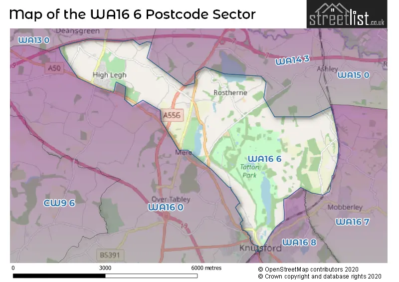
The WA16 6 postcode sector is within the county of Cheshire.
Did you know? According to the 2021 Census, the WA16 6 postcode sector is home to a bustling 3,297 residents!
Given that each sector allows for 400 unique postcode combinations. Letters C, I, K, M, O and V are not allowed in the last two letters of a postcode. With 211 postcodes already in use, this leaves 189 units available.
The largest settlement in the WA16 6 postal code is KNUTSFORD followed by High Legh, and Mere.
The WA16 6 Postcode shares a border with WA14 3 (Bowdon, Hale, Ashley), WA13 0 (LYMM), WA16 0 (KNUTSFORD, Pickmere, High Legh), WA16 7 (Mobberley, Marthall, KNUTSFORD), WA16 8 (KNUTSFORD, Ollerton, Over Peover) and WA16 9 (KNUTSFORD, Allostock, Lower Peover).
The sector is within the post town of KNUTSFORD.
WA16 6 is a postcode sector within the WA16 postcode district which is within the WA Warrington postcode area.
The Royal Mail delivery office for the WA16 6 postal sector is the Knutsford Delivery Office.
The area of the WA16 6 postcode sector is 8.90 square miles which is 23.06 square kilometres or 5,698.87 square acres.
The WA16 6 postcode sector is crossed by the A556 Major A road.
The WA16 6 postcode sector is crossed by the M56 motorway.

Map of the WA16 6 Postcode Sector
Explore the WA16 6 postcode sector by using our free interactive map.
| W | A | 1 | 6 | - | 6 | X | X |
| W | A | 1 | 6 | Space | 6 | Letter | Letter |
Official List of Streets
KNUTSFORD (36 Streets)
High Legh (33 Streets)
Mere (8 Streets)
Mobberley (8 Streets)
Bucklow Hill (4 Streets)
Rostherne (5 Streets)
Rostherne Village (1 Streets)
Unofficial Streets or Alternative Spellings
Ashley
ASHLEY ROAD CHERRY TREE LANE MOBBERLEY ROADMobberley
BREACH HOUSE LANE HOBCROFT LANEKNUTSFORD
KING EDWARD ROAD PARKGATE LANE STANLEY ROADMere
MANCHESTER ROAD BACK LANE BUCKLOWHILL LANE CHURCH WALK CICELY MILL LANE COTTON SHOP YARD CRESCENT ROAD ELIZABETH GASKELL COURT HERITAGE WAY HULSEHEATH LANE KELLHOUSE LANE KNUTSFORD DRIVE LIMETREE LANE MERE COURT MERE MILL LANE MEREHEATH DRIVE MILLINGTON ROUNDABOUT ROSTHERNE DRIVE SLATERS COURT TATTON COURT THE CIRCLE WHISTON CLOSEMillington
MILLINGTON HALL LANE MILLINGTON LANE THOWLER LANEParkgate Industrial Estate
HAIG ROADToft
TOFT ROADAgden
AGDEN LANE BOOTHBANK LANEWeather Forecast for WA16 6
Press Button to Show Forecast for Tatton Park
| Time Period | Icon | Description | Temperature | Rain Probability | Wind |
|---|---|---|---|---|---|
| 12:00 to 15:00 | Cloudy | 15.0°C (feels like 12.0°C) | 5.00% | SSE 16 mph | |
| 15:00 to 18:00 | Cloudy | 17.0°C (feels like 13.0°C) | 5.00% | SSE 16 mph | |
| 18:00 to 21:00 | Cloudy | 14.0°C (feels like 12.0°C) | 6.00% | S 11 mph | |
| 21:00 to 00:00 | Cloudy | 12.0°C (feels like 10.0°C) | 6.00% | S 9 mph |
Press Button to Show Forecast for Tatton Park
| Time Period | Icon | Description | Temperature | Rain Probability | Wind |
|---|---|---|---|---|---|
| 00:00 to 03:00 | Cloudy | 11.0°C (feels like 10.0°C) | 12.00% | ESE 7 mph | |
| 03:00 to 06:00 | Cloudy | 10.0°C (feels like 9.0°C) | 7.00% | ESE 4 mph | |
| 06:00 to 09:00 | Cloudy | 11.0°C (feels like 10.0°C) | 4.00% | E 4 mph | |
| 09:00 to 12:00 | Cloudy | 14.0°C (feels like 13.0°C) | 5.00% | S 4 mph | |
| 12:00 to 15:00 | Cloudy | 16.0°C (feels like 16.0°C) | 11.00% | NE 7 mph | |
| 15:00 to 18:00 | Cloudy | 17.0°C (feels like 16.0°C) | 15.00% | NE 7 mph | |
| 18:00 to 21:00 | Cloudy | 15.0°C (feels like 14.0°C) | 14.00% | NNE 7 mph | |
| 21:00 to 00:00 | Cloudy | 14.0°C (feels like 13.0°C) | 6.00% | NNE 7 mph |
Press Button to Show Forecast for Tatton Park
| Time Period | Icon | Description | Temperature | Rain Probability | Wind |
|---|---|---|---|---|---|
| 00:00 to 03:00 | Cloudy | 11.0°C (feels like 9.0°C) | 5.00% | NNE 9 mph | |
| 03:00 to 06:00 | Cloudy | 10.0°C (feels like 8.0°C) | 5.00% | NNE 11 mph | |
| 06:00 to 09:00 | Cloudy | 11.0°C (feels like 9.0°C) | 4.00% | NNE 9 mph | |
| 09:00 to 12:00 | Partly cloudy (day) | 14.0°C (feels like 12.0°C) | 1.00% | NE 11 mph | |
| 12:00 to 15:00 | Sunny day | 19.0°C (feels like 16.0°C) | 0.00% | ENE 13 mph | |
| 15:00 to 18:00 | Sunny day | 20.0°C (feels like 17.0°C) | 3.00% | ENE 11 mph | |
| 18:00 to 21:00 | Partly cloudy (day) | 17.0°C (feels like 15.0°C) | 2.00% | ENE 11 mph | |
| 21:00 to 00:00 | Partly cloudy (night) | 12.0°C (feels like 11.0°C) | 1.00% | NE 7 mph |
Press Button to Show Forecast for Tatton Park
| Time Period | Icon | Description | Temperature | Rain Probability | Wind |
|---|---|---|---|---|---|
| 00:00 to 03:00 | Partly cloudy (night) | 10.0°C (feels like 9.0°C) | 1.00% | NNE 4 mph | |
| 03:00 to 06:00 | Cloudy | 10.0°C (feels like 9.0°C) | 8.00% | NNE 4 mph | |
| 06:00 to 09:00 | Overcast | 11.0°C (feels like 10.0°C) | 10.00% | NNE 2 mph | |
| 09:00 to 12:00 | Cloudy | 13.0°C (feels like 12.0°C) | 12.00% | WNW 4 mph | |
| 12:00 to 15:00 | Cloudy | 14.0°C (feels like 13.0°C) | 12.00% | NW 7 mph | |
| 15:00 to 18:00 | Light rain | 15.0°C (feels like 14.0°C) | 44.00% | NW 7 mph | |
| 18:00 to 21:00 | Light rain | 14.0°C (feels like 13.0°C) | 46.00% | W 7 mph | |
| 21:00 to 00:00 | Overcast | 12.0°C (feels like 11.0°C) | 17.00% | WSW 7 mph |
Press Button to Show Forecast for Tatton Park
| Time Period | Icon | Description | Temperature | Rain Probability | Wind |
|---|---|---|---|---|---|
| 00:00 to 03:00 | Light rain | 11.0°C (feels like 10.0°C) | 42.00% | SW 7 mph | |
| 03:00 to 06:00 | Overcast | 10.0°C (feels like 9.0°C) | 15.00% | SW 7 mph | |
| 06:00 to 09:00 | Cloudy | 10.0°C (feels like 9.0°C) | 10.00% | S 7 mph | |
| 09:00 to 12:00 | Overcast | 12.0°C (feels like 11.0°C) | 13.00% | SSW 7 mph | |
| 12:00 to 15:00 | Cloudy | 15.0°C (feels like 14.0°C) | 11.00% | SW 7 mph | |
| 15:00 to 18:00 | Cloudy | 17.0°C (feels like 15.0°C) | 11.00% | SW 7 mph | |
| 18:00 to 21:00 | Cloudy | 15.0°C (feels like 14.0°C) | 10.00% | W 7 mph | |
| 21:00 to 00:00 | Partly cloudy (night) | 12.0°C (feels like 11.0°C) | 5.00% | W 7 mph |
Schools and Places of Education Within the WA16 6 Postcode Sector
High Legh Primary School
Community school
Wrenshot Lane, Knutsford, Cheshire, WA16 6NW
Head: Mrs Louise Tottle
Ofsted Rating: Good
Inspection: 2022-07-19 (651 days ago)
Website: Visit High Legh Primary School Website
Phone: 01925753713
Number of Pupils: 158
House Prices in the WA16 6 Postcode Sector
| Type of Property | 2018 Average | 2018 Sales | 2017 Average | 2017 Sales | 2016 Average | 2016 Sales | 2015 Average | 2015 Sales |
|---|---|---|---|---|---|---|---|---|
| Detached | £936,647 | 17 | £678,188 | 24 | £590,517 | 30 | £587,185 | 28 |
| Semi-Detached | £363,283 | 10 | £342,499 | 9 | £364,850 | 7 | £326,619 | 8 |
| Terraced | £387,684 | 16 | £378,291 | 17 | £488,460 | 29 | £322,356 | 18 |
| Flats | £218,800 | 15 | £205,112 | 13 | £149,264 | 15 | £147,462 | 16 |
Important Postcodes WA16 6 in the Postcode Sector
WA16 6NW is the postcode for High Legh Primary School, Wrenshot Lane, and High Legh School, Wrenshot Lane
WA16 6TA is the postcode for Knutsford Town Council, Council Offices, Toft Road
| The WA16 6 Sector is within these Local Authorities |
|
|---|---|
| The WA16 6 Sector is within these Counties |
|
| The WA16 6 Sector is within these Water Company Areas |
|
Tourist Attractions within the WA16 6 Postcode Area
We found 2 visitor attractions within the WA16 postcode area
| Tatton Park |
|---|
| Historic Properties |
| Historic House / House and Garden / Palace |
| View Tatton Park on Google Maps |
| Knutsford Heritage Centre |
| Visitor Centres |
| Heritage / Visitor Centre |
| View Knutsford Heritage Centre on Google Maps |