The WA16 9 postcode sector is within the county of Cheshire.
Did you know? According to the 2021 Census, the WA16 9 postcode sector is home to a bustling 3,948 residents!
Given that each sector allows for 400 unique postcode combinations. Letters C, I, K, M, O and V are not allowed in the last two letters of a postcode. With 207 postcodes already in use, this leaves 193 units available.
The largest settlement in the WA16 9 postal code is KNUTSFORD followed by Allostock, and Lower Peover.
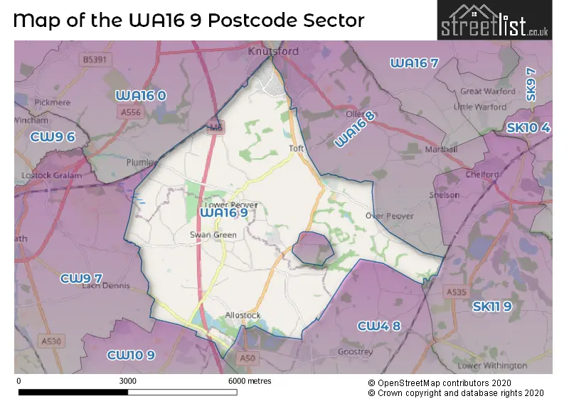
The WA16 9 Postcode shares a border with SK11 9 (Chelford, Gawsworth, Lower Withington), WA16 6 (KNUTSFORD, High Legh, Mere), CW9 7 (NORTHWICH, Rudheath, Lostock Gralam), CW10 9 (MIDDLEWICH, Byley, Bostock), WA16 0 (KNUTSFORD, Pickmere, High Legh), WA16 8 (KNUTSFORD, Ollerton, Over Peover) and CW4 8 (Goostrey, Holmes Chapel, Cranage).
The sector is within the post town of KNUTSFORD.
WA16 9 is a postcode sector within the WA16 postcode district which is within the WA Warrington postcode area.
The Royal Mail delivery office for the WA16 9 postal sector is the Knutsford Delivery Office.
The area of the WA16 9 postcode sector is 13.11 square miles which is 33.94 square kilometres or 8,387.73 square acres.
The WA16 9 postcode sector is crossed by the M6 motorway.
Waterways within the WA16 9 postcode sector include the Peover Eye.

Map of the WA16 9 Postcode Sector
Explore the WA16 9 postcode sector by using our free interactive map.
| W | A | 1 | 6 | - | 9 | X | X |
| W | A | 1 | 6 | Space | 9 | Letter | Letter |
Official List of Streets
KNUTSFORD (25 Streets)
Lower Peover (20 Streets)
Plumley (7 Streets)
Allostock (15 Streets)
Over Peover (6 Streets)
Toft (4 Streets)
Cranage (1 Streets)
Unofficial Streets or Alternative Spellings
Over Peover
CLAY LANE PATTON CLOSEKNUTSFORD
ADAMS HILL CROFT LANE STANLEY ROAD WOODVALE ROADTabley
SUDLOW LANEGoostrey
BLACKDEN LANECranage
SANDY LANE ALLOSTOCK 20 ALLOSTOCK 21 ALLOSTOCK 22 ALLOSTOCK 23 BARROWS BROW BEGGAR MANS LANE BOOTHBED LANE BOOTS GREEN CAPE LANE CHURCH WALK GOOSTREY LANE GOUGHS LANE KINGS LANE MERRY LANE MILL LANE WITHINGTON LANEByley
BYLEY LANEChelford
BATEMILL LANEToft
SANDY LANEOllerton
SEVEN SISTERS LANELach Dennis
COMMON LANEWeather Forecast for WA16 9
Press Button to Show Forecast for Knutsford
| Time Period | Icon | Description | Temperature | Rain Probability | Wind |
|---|---|---|---|---|---|
| 18:00 to 21:00 | Cloudy | 14.0°C (feels like 12.0°C) | 6.00% | S 11 mph | |
| 21:00 to 00:00 | Cloudy | 12.0°C (feels like 10.0°C) | 8.00% | S 7 mph |
Press Button to Show Forecast for Knutsford
| Time Period | Icon | Description | Temperature | Rain Probability | Wind |
|---|---|---|---|---|---|
| 00:00 to 03:00 | Cloudy | 11.0°C (feels like 10.0°C) | 12.00% | SE 7 mph | |
| 03:00 to 06:00 | Partly cloudy (night) | 10.0°C (feels like 9.0°C) | 4.00% | ESE 7 mph | |
| 06:00 to 09:00 | Partly cloudy (day) | 11.0°C (feels like 10.0°C) | 2.00% | ESE 4 mph | |
| 09:00 to 12:00 | Cloudy | 14.0°C (feels like 14.0°C) | 5.00% | SSE 4 mph | |
| 12:00 to 15:00 | Cloudy | 17.0°C (feels like 16.0°C) | 10.00% | NE 7 mph | |
| 15:00 to 18:00 | Cloudy | 17.0°C (feels like 16.0°C) | 34.00% | ENE 7 mph | |
| 18:00 to 21:00 | Cloudy | 15.0°C (feels like 14.0°C) | 14.00% | NE 9 mph | |
| 21:00 to 00:00 | Cloudy | 13.0°C (feels like 12.0°C) | 6.00% | NNE 9 mph |
Press Button to Show Forecast for Knutsford
| Time Period | Icon | Description | Temperature | Rain Probability | Wind |
|---|---|---|---|---|---|
| 00:00 to 03:00 | Cloudy | 11.0°C (feels like 9.0°C) | 5.00% | NE 11 mph | |
| 03:00 to 06:00 | Cloudy | 10.0°C (feels like 8.0°C) | 4.00% | NNE 9 mph | |
| 06:00 to 09:00 | Cloudy | 11.0°C (feels like 9.0°C) | 4.00% | NE 9 mph | |
| 09:00 to 12:00 | Partly cloudy (day) | 14.0°C (feels like 12.0°C) | 1.00% | NE 13 mph | |
| 12:00 to 15:00 | Sunny day | 19.0°C (feels like 16.0°C) | 0.00% | ENE 13 mph | |
| 15:00 to 18:00 | Partly cloudy (day) | 19.0°C (feels like 16.0°C) | 1.00% | ENE 13 mph | |
| 18:00 to 21:00 | Partly cloudy (day) | 16.0°C (feels like 14.0°C) | 2.00% | ENE 11 mph | |
| 21:00 to 00:00 | Partly cloudy (night) | 12.0°C (feels like 10.0°C) | 1.00% | NE 11 mph |
Press Button to Show Forecast for Knutsford
| Time Period | Icon | Description | Temperature | Rain Probability | Wind |
|---|---|---|---|---|---|
| 00:00 to 03:00 | Partly cloudy (night) | 10.0°C (feels like 9.0°C) | 1.00% | ENE 4 mph | |
| 03:00 to 06:00 | Cloudy | 10.0°C (feels like 9.0°C) | 6.00% | NE 4 mph | |
| 06:00 to 09:00 | Cloudy | 11.0°C (feels like 10.0°C) | 9.00% | NE 2 mph | |
| 09:00 to 12:00 | Cloudy | 13.0°C (feels like 12.0°C) | 11.00% | NW 4 mph | |
| 12:00 to 15:00 | Cloudy | 14.0°C (feels like 13.0°C) | 12.00% | NW 7 mph | |
| 15:00 to 18:00 | Light rain | 14.0°C (feels like 13.0°C) | 44.00% | NW 7 mph | |
| 18:00 to 21:00 | Overcast | 14.0°C (feels like 12.0°C) | 19.00% | WNW 7 mph | |
| 21:00 to 00:00 | Overcast | 12.0°C (feels like 11.0°C) | 16.00% | WSW 7 mph |
Press Button to Show Forecast for Knutsford
| Time Period | Icon | Description | Temperature | Rain Probability | Wind |
|---|---|---|---|---|---|
| 00:00 to 03:00 | Overcast | 11.0°C (feels like 10.0°C) | 15.00% | SW 7 mph | |
| 03:00 to 06:00 | Overcast | 10.0°C (feels like 9.0°C) | 15.00% | SW 4 mph | |
| 06:00 to 09:00 | Cloudy | 10.0°C (feels like 9.0°C) | 13.00% | SSW 4 mph | |
| 09:00 to 12:00 | Overcast | 12.0°C (feels like 11.0°C) | 13.00% | SSW 7 mph | |
| 12:00 to 15:00 | Cloudy | 15.0°C (feels like 13.0°C) | 11.00% | SW 7 mph | |
| 15:00 to 18:00 | Cloudy | 16.0°C (feels like 15.0°C) | 10.00% | SW 7 mph | |
| 18:00 to 21:00 | Cloudy | 15.0°C (feels like 13.0°C) | 10.00% | W 9 mph | |
| 21:00 to 00:00 | Cloudy | 12.0°C (feels like 11.0°C) | 7.00% | W 7 mph |
Schools and Places of Education Within the WA16 9 Postcode Sector
Bexton Primary School
Academy converter
Blackhill Lane, Knutsford, Cheshire, WA16 9DB
Head: Mrs Emily Armstrong
Ofsted Rating: Good
Inspection: 2023-04-19 (377 days ago)
Website: Visit Bexton Primary School Website
Phone: 01565632816
Number of Pupils: 477
Lower Peover CofE Primary School
Voluntary aided school
The Cobbles, Knutsford, Cheshire, WA16 9PZ
Head: Mrs Sharon Dean
Ofsted Rating: Outstanding
Inspection: 2013-05-15 (4003 days ago)
Website: Visit Lower Peover CofE Primary School Website
Phone: 01625467623
Number of Pupils: 204
House Prices in the WA16 9 Postcode Sector
| Type of Property | 2018 Average | 2018 Sales | 2017 Average | 2017 Sales | 2016 Average | 2016 Sales | 2015 Average | 2015 Sales |
|---|---|---|---|---|---|---|---|---|
| Detached | £558,859 | 37 | £628,340 | 44 | £630,911 | 41 | £518,628 | 39 |
| Semi-Detached | £407,300 | 5 | £467,409 | 11 | £468,375 | 8 | £358,281 | 16 |
| Terraced | £289,250 | 4 | £421,000 | 4 | £590,250 | 6 | £226,538 | 4 |
| Flats | £340,000 | 1 | £625,000 | 1 | £0 | 0 | £0 | 0 |
Important Postcodes WA16 9 in the Postcode Sector
WA16 9DB is the postcode for Bexton Primary School and nursery., Blackhill Lane, THE TOFT BUILDING, Bexton Primary School, Blackhill Lane, and Bexton Primary School, Blackhill Lane
WA16 9DX is the postcode for Toft Road Surgery, Toft Road
WA16 9PZ is the postcode for Lower Peover C of E Primary School, The Cobbles, and LOWER PEOVER CHURCH OF ENGLAND PRIMARY SCHOOL, THE COBBLES, NETHER PEOVER
| The WA16 9 Sector is within these Local Authorities |
|
|---|---|
| The WA16 9 Sector is within these Counties |
|
| The WA16 9 Sector is within these Water Company Areas |
|