The WA5 9 postcode sector is within the county of Cheshire.
Did you know? According to the 2021 Census, the WA5 9 postcode sector is home to a bustling 5,328 residents!
Given that each sector allows for 400 unique postcode combinations. Letters C, I, K, M, O and V are not allowed in the last two letters of a postcode. With 87 postcodes already in use, this leaves 313 units available.
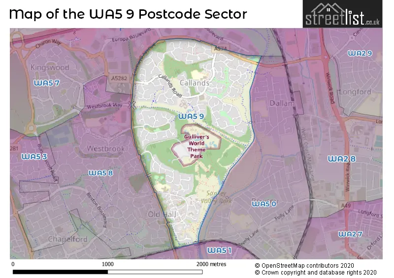
The largest settlements in the WA5 9 postal code are Callands and Old Hall.
The WA5 9 Postcode shares a border with WA5 0 (WARRINGTON, Bewsey), WA5 8 (Great Sankey, Old Hall, Westbrook), WA5 1 (Great Sankey, WARRINGTON) and WA5 7 (Westbrook).
The sector is within the post town of WARRINGTON.
WA5 9 is a postcode sector within the WA5 postcode district which is within the WA Warrington postcode area.
The Royal Mail delivery office for the WA5 9 postal sector is the Warrington Delivery Office.
The area of the WA5 9 postcode sector is 0.78 square miles which is 2.02 square kilometres or 499.37 square acres.
Waterways within the WA5 9 postcode sector include the Sankey Brook, St Helens Canal.

Map of the WA5 9 Postcode Sector
Explore the WA5 9 postcode sector by using our free interactive map.
| W | A | 5 | - | 9 | X | X |
| W | A | 5 | Space | 9 | Letter | Letter |
Official List of Streets
Callands (46 Streets)
Old Hall (20 Streets)
Bewsey (1 Streets)
Unofficial Streets or Alternative Spellings
Schools and Places of Education Within the WA5 9 Postcode Sector
Callands Community Primary School
Community school
Callands Road, Warrington, Cheshire, WA5 9RJ
Head: Mrs Siobhan Bentley
Ofsted Rating: Outstanding
Inspection: 2023-06-15 (343 days ago)
Website: Visit Callands Community Primary School Website
Phone: 01925444795
Number of Pupils: 409
Westbrook Old Hall Primary School
Academy converter
Old Hall Road, Warrington, Cheshire, WA5 9QA
Head: Mrs Mary Lythall-Brennan
Ofsted Rating: Good
Inspection: 2022-05-05 (749 days ago)
Website: Visit Westbrook Old Hall Primary School Website
Phone: 01925415544
Number of Pupils: 380
House Prices in the WA5 9 Postcode Sector
| Type of Property | 2018 Average | 2018 Sales | 2017 Average | 2017 Sales | 2016 Average | 2016 Sales | 2015 Average | 2015 Sales |
|---|---|---|---|---|---|---|---|---|
| Detached | £242,686 | 37 | £225,242 | 38 | £222,441 | 33 | £216,357 | 43 |
| Semi-Detached | £152,887 | 31 | £142,598 | 25 | £151,494 | 18 | £131,167 | 15 |
| Terraced | £110,200 | 5 | £115,300 | 10 | £111,371 | 12 | £87,944 | 9 |
| Flats | £92,988 | 4 | £114,488 | 4 | £112,279 | 7 | £154,000 | 2 |
Important Postcodes WA5 9 in the Postcode Sector
WA5 9PB is the postcode for Bewsey Barn Community Centre, Bewsey Barn Close
WA5 9QA is the postcode for Westbrook Old Hall Community Primary School, Old Hall Road, Old Hall, and Westbrook Old Hall Community Primary School, Old Hall Road
WA5 9RJ is the postcode for Callands Community Primary School, Callands Road, Burtonwood And Westbrook, Callands Primary School, Callands Road, Callands, Callands Primary School, Callands Road, Woodleigh Residential Home, Callands Road, and Callands Cp School, Callands Road
| The WA5 9 Sector is within these Local Authorities |
|
|---|---|
| The WA5 9 Sector is within these Counties |
|
| The WA5 9 Sector is within these Water Company Areas |
|