The WA6 8 postcode sector is within the county of Cheshire.
Did you know? According to the 2021 Census, the WA6 8 postcode sector is home to a bustling 2,230 residents!
Given that each sector allows for 400 unique postcode combinations. Letters C, I, K, M, O and V are not allowed in the last two letters of a postcode. With 149 postcodes already in use, this leaves 251 units available.
The largest settlements in the WA6 8 postal code are Kingsley and Norley.
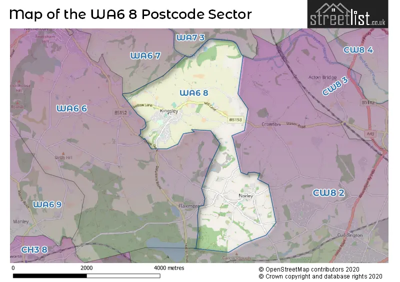
The WA6 8 Postcode shares a border with WA6 6 (FRODSHAM, Norley, Kingswood), CW8 2 (Cuddington, Sandiway, Oakmere), WA6 7 (FRODSHAM, Bradley) and WA7 3 (Beechwood, Sutton Weaver, Preston Brook).
The sector is within the post town of FRODSHAM.
WA6 8 is a postcode sector within the WA6 postcode district which is within the WA Warrington postcode area.
The Royal Mail delivery office for the WA6 8 postal sector is the Frodsham Delivery Office.
The area of the WA6 8 postcode sector is 4.10 square miles which is 10.62 square kilometres or 2,623.23 square acres.
Waterways within the WA6 8 postcode sector include the River Weaver, Small Brook.

Map of the WA6 8 Postcode Sector
Explore the WA6 8 postcode sector by using our free interactive map.
| W | A | 6 | - | 8 | X | X |
| W | A | 6 | Space | 8 | Letter | Letter |
Official List of Streets
Kingsley (34 Streets)
Norley (29 Streets)
Unofficial Streets or Alternative Spellings
Crowton
BAG LANE CREWOOD COMMON ROAD KINGSLEY ROAD MARSH LANE NORLEY LANENorley
CROWTON VIEWCuddington
DUTTON LANE NORLEY ROAD CHAMBERBROOK LANE FINGER POST LANE GUEST SLACK HIGH BANK ROAD HURST MEWS PYTCHELEY HOLLOW STANNYBROOK LANE THE WOB YEARSLEYS LANEKingsley
BEECH LANE COOKS HILL NORLEY ROADFRODSHAM
DEPMORE LANESchools and Places of Education Within the WA6 8 Postcode Sector
Kingsley St John's CofE (VA) Primary School
Voluntary aided school
Hollow Lane, Frodsham, Cheshire, WA6 8EF
Head: Mrs Rachel Jones
Ofsted Rating: Good
Inspection: 2023-11-14 (167 days ago)
Website: Visit Kingsley St John's CofE (VA) Primary School Website
Phone: 01244738434
Number of Pupils: 71
House Prices in the WA6 8 Postcode Sector
| Type of Property | 2018 Average | 2018 Sales | 2017 Average | 2017 Sales | 2016 Average | 2016 Sales | 2015 Average | 2015 Sales |
|---|---|---|---|---|---|---|---|---|
| Detached | £411,893 | 14 | £448,271 | 24 | £456,134 | 22 | £387,781 | 16 |
| Semi-Detached | £350,075 | 10 | £340,000 | 6 | £317,955 | 11 | £326,542 | 6 |
| Terraced | £140,000 | 2 | £379,000 | 1 | £275,333 | 3 | £312,250 | 3 |
| Flats | £0 | 0 | £0 | 0 | £0 | 0 | £0 | 0 |
Important Postcodes WA6 8 in the Postcode Sector
WA6 8EF is the postcode for St. Johns C of E Primary School, Hollow Lane
WA6 8JZ is the postcode for Norley C of E Primary School, Hough Lane
| The WA6 8 Sector is within these Local Authorities |
|
|---|---|
| The WA6 8 Sector is within these Counties |
|
| The WA6 8 Sector is within these Water Company Areas |
|