The WF17 6 postcode sector is within the county of West Yorkshire.
Did you know? According to the 2021 Census, the WF17 6 postcode sector is home to a bustling 6,823 residents!
Given that each sector allows for 400 unique postcode combinations. Letters C, I, K, M, O and V are not allowed in the last two letters of a postcode. With 173 postcodes already in use, this leaves 227 units available.
The largest settlement in the WF17 6 postal code is BATLEY followed by Soothill, and Hanging Heaton.
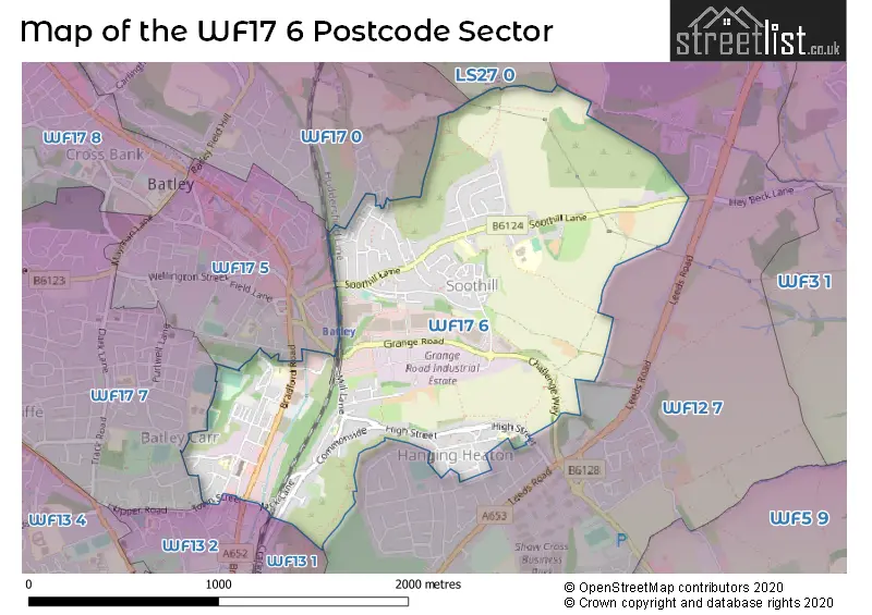
The WF17 6 Postcode shares a border with WF13 1 (DEWSBURY, Crackenedge), WF13 2 (DEWSBURY, Westtown, Batley Carr), WF17 7 (BATLEY), WF12 7 (DEWSBURY, Earlsheaton, Shaw Cross Business Park), WF17 0 (BATLEY, Birstall, Soothill), WF17 5 (BATLEY) and LS27 0 (Morley).
The sector is within the post town of BATLEY.
WF17 6 is a postcode sector within the WF17 postcode district which is within the WF Wakefield postcode area.
The Royal Mail delivery office for the WF17 6 postal sector is the Batley Delivery Office.
The area of the WF17 6 postcode sector is 1.21 square miles which is 3.13 square kilometres or 772.63 square acres.

Map of the WF17 6 Postcode Sector
Explore the WF17 6 postcode sector by using our free interactive map.
| W | F | 1 | 7 | - | 6 | X | X |
| W | F | 1 | 7 | Space | 6 | Letter | Letter |
Official List of Streets
BATLEY (54 Streets)
Soothill (41 Streets)
Unofficial Streets or Alternative Spellings
BATLEY
HERITAGE ROAD HYRSTLANDS ROAD PRIMROSE HILL ROUSE MILL LANE ROYD STREET BACK MOUNT AVENUE BACK WARWICK TERRACE CHALLENGE WAY CROSSMOUNT STREET GROVE FARM JENKINSON STREET RINK STREET SYKES LANE UPPER WEST STREETBATLEY,
BENNETT LANE CROFTLANDS SAVILE STREETBirstall
BRADFORD ROADDEWSBURY
CRACKENEDGE LANE DERWENT ROAD MILTON GROVEBatley Carr
TOWN STREETSchools and Places of Education Within the WF17 6 Postcode Sector
Hanging Heaton Church of England Voluntary Controlled Junior and Infant School
Voluntary controlled school
High Street, Batley, West Yorkshire, WF17 6DW
Head: Mrs Janet Potter
Ofsted Rating: Good
Inspection: 2022-12-14 (532 days ago)
Website: Visit Hanging Heaton Church of England Voluntary Controlled Junior and Infant School Website
Phone: 01924463035
Number of Pupils: 134
Lydgate Junior and Infant School
Community school
Lydgate Road, Batley, West Yorkshire, WF17 6EY
Head: Mrs Anita Kishore
Ofsted Rating: Good
Inspection: 2019-10-16 (1687 days ago)
Website: Visit Lydgate Junior and Infant School Website
Phone: 01924476218
Number of Pupils: 276
Mill Lane Primary School
Community school
Mill Lane, Batley, West Yorkshire, WF17 6EG
Head: Ms Christine Barlow
Ofsted Rating: Requires improvement
Inspection: 2022-05-20 (740 days ago)
Website: Visit Mill Lane Primary School Website
Phone: 01924477544
Number of Pupils: 162
Warwick Road Primary School
Community school
Warwick Road, Batley, West Yorkshire, WF17 6BS
Head: Mrs Shamsa Qureshi
Ofsted Rating: Good
Inspection: 2019-03-12 (1905 days ago)
Website: Visit Warwick Road Primary School Website
Phone: 01924455593
Number of Pupils: 384
House Prices in the WF17 6 Postcode Sector
| Type of Property | 2018 Average | 2018 Sales | 2017 Average | 2017 Sales | 2016 Average | 2016 Sales | 2015 Average | 2015 Sales |
|---|---|---|---|---|---|---|---|---|
| Detached | £172,691 | 11 | £202,278 | 9 | £228,679 | 7 | £178,333 | 6 |
| Semi-Detached | £142,680 | 25 | £143,016 | 29 | £131,688 | 24 | £133,088 | 20 |
| Terraced | £85,737 | 53 | £94,056 | 57 | £91,506 | 37 | £73,727 | 22 |
| Flats | £67,000 | 1 | £53,400 | 5 | £89,750 | 2 | £76,313 | 4 |
Important Postcodes WF17 6 in the Postcode Sector
WF17 6BS is the postcode for Warwick Road Junior Infant & Nursery School, Warwick Road
WF17 6DW is the postcode for Hanging Heaton C of E School, High Street
WF17 6EG is the postcode for Mill Lane Junior & Infant School, Mill Lane
WF17 6ER is the postcode for Annexe 4, Batley Business Park, and Main Building, Batley Business Park
WF17 6EY is the postcode for Lydgate Junior & Infant School, Lydgate Road, and LYDGATE JUNIOR AND INFANT SCHOOL, LYDGATE ROAD, SOOTHILL
| The WF17 6 Sector is within these Local Authorities |
|
|---|---|
| The WF17 6 Sector is within these Counties |
|
| The WF17 6 Sector is within these Water Company Areas |
|