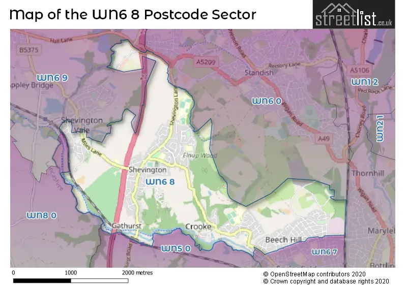
The WN6 8 postcode sector stands on the Greater Manchester and Lancashire border.
Did you know? According to the 2021 Census, the WN6 8 postcode sector is home to a bustling 11,683 residents!
Given that each sector allows for 400 unique postcode combinations. Letters C, I, K, M, O and V are not allowed in the last two letters of a postcode. With 219 postcodes already in use, this leaves 181 units available.
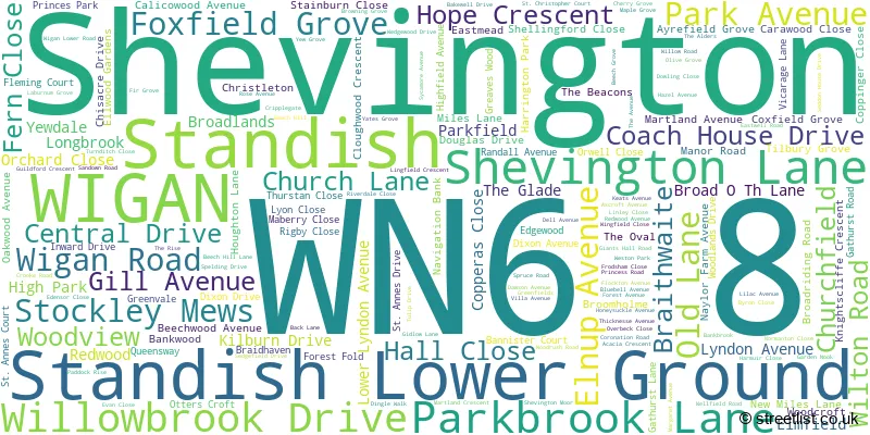
The largest settlement in the WN6 8 postal code is Shevington followed by WIGAN, and Standish Lower Ground.
The WN6 8 Postcode shares a border with WN5 0 (WIGAN, Orrell, Martland Park), WN6 7 (WIGAN), WN1 2 (WIGAN, Standish, Haigh), WN5 8 (Orrell, WIGAN, Pemberton), WN6 0 (Standish), WN6 9 (Appley Bridge, Wrightington) and WN8 0 (Upholland, SKELMERSDALE, Roby Mill).
The sector is within the post town of WIGAN.
WN6 8 is a postcode sector within the WN6 postcode district which is within the WN Wigan postcode area.
The Royal Mail delivery office for the WN6 8 postal sector is the Wigan Delivery Office.
The area of the WN6 8 postcode sector is 3.02 square miles which is 7.82 square kilometres or 1,933.53 square acres.
The WN6 8 postcode sector is crossed by the M6 motorway.
Waterways within the WN6 8 postcode sector include the River Douglas, Leeds and Liverpool Canal.

Map of the WN6 8 Postcode Sector
Explore the WN6 8 postcode sector by using our free interactive map.
| W | N | 6 | - | 8 | X | X |
| W | N | 6 | Space | 8 | Letter | Letter |
Official List of Streets
WIGAN (43 Streets)
Shevington (90 Streets)
Standish (2 Streets)
Standish Lower Ground (29 Streets)
Unofficial Streets or Alternative Spellings
WIGAN
BEECH HILL AVENUE SPRINGFIELD ROAD WOODHOUSE DRIVE WOODHOUSE LANE BLUE BELL AVENUE COXFIELD CRIPPLE GATE CROOKE BRIDGE GATHURST VIADUCT HARRTINGTON PARK NAYLORFARM AVENUE SANDALWOOD DRIVE SHAFTSBURY STREET SHEVINGTON INTERCHANGE STANDISH WOOD LANE WOOD VIEWAppley Bridge
ABBEYDALE ASH CLOSE BACK LANE MILES LANEWrightington
CROW ORCHARD ROAD MOSSY LEA ROADStandish
SOUTH WHITEACREOrrell
GATHURST ROADSchools and Places of Education Within the WN6 8 Postcode Sector
Millbrook Primary School
Community school
Elmfield, Wigan, Lancashire, WN6 8DL
Head: Mrs Karen Tomlinson
Ofsted Rating: Good
Inspection: 2022-07-14 (679 days ago)
Website: Visit Millbrook Primary School Website
Phone: 01257404552
Number of Pupils: 205
Shevington High School
Community school
Shevington Lane, Wigan, Lancashire, WN6 8AB
Head: Mr Julian Grant
Ofsted Rating: Good
Inspection: 2022-03-16 (799 days ago)
Website: Visit Shevington High School Website
Phone: 01257400990
Number of Pupils: 841
St Bernadette's Catholic Primary School
Voluntary aided school
Church Lane, Wigan, Lancashire, WN6 8BD
Head: Mrs Helen Crowder
Ofsted Rating: Good
Inspection: 2023-07-12 (316 days ago)
Website: Visit St Bernadette's Catholic Primary School Website
Phone: 01257401125
Number of Pupils: 182
Standish Lower Ground St Anne's CofE Primary School
Voluntary aided school
Wigan Lower Road, Wigan, Lancashire, WN6 8JP
Head: Mr Philip Ivory
Ofsted Rating: Good
Inspection: 2019-09-12 (1715 days ago)
Website: Visit Standish Lower Ground St Anne's CofE Primary School Website
Phone: 01942511348
Number of Pupils: 153
House Prices in the WN6 8 Postcode Sector
| Type of Property | 2018 Average | 2018 Sales | 2017 Average | 2017 Sales | 2016 Average | 2016 Sales | 2015 Average | 2015 Sales |
|---|---|---|---|---|---|---|---|---|
| Detached | £227,418 | 25 | £248,289 | 53 | £217,201 | 52 | £235,860 | 68 |
| Semi-Detached | £146,111 | 80 | £140,009 | 107 | £141,104 | 99 | £137,798 | 88 |
| Terraced | £109,932 | 30 | £111,330 | 36 | £118,618 | 38 | £127,339 | 39 |
| Flats | £42,875 | 2 | £56,000 | 2 | £33,000 | 1 | £0 | 0 |
Important Postcodes WN6 8 in the Postcode Sector
WN6 8AB is the postcode for MAIN BLOCK, Shevington County High School, Shevington Lane, Shevington County High School, Shevington Lane, SPORTS HALL, Shevington County High School, Shevington Lane, SCIENCE BLOCK, Shevington County High School, Shevington Lane, and DINING / MATHS BLOCK, Shevington County High School, Shevington Lane
WN6 8BD is the postcode for St. Bernadettes RC Primary School, Church Lane, Shevington, and St. Bernadettes RC Primary School, Church Lane
WN6 8DL is the postcode for Millbrook Cp School, Elmfield, Shevington, and Millbrook Cp School, Elmfield
WN6 8ET is the postcode for Shevington Surgery, 1 Houghton Lane
WN6 8EW is the postcode for Shevington Clinic, 77 Miles Lane, Shevington, INFANTS BLOCK, Shevington Cp School, Miles Lane, Shevington Cp School, Miles Lane, and JUNIOR BLOCK, Shevington Cp School, Miles Lane
WN6 8HA is the postcode for Shevington Library, Gathurst Lane
WN6 8JP is the postcode for St Annes C of E Primary School, Wigan Lower Road
| The WN6 8 Sector is within these Local Authorities |
|
|---|---|
| The WN6 8 Sector is within these Counties |
|
| The WN6 8 Sector is within these Water Company Areas |
|