The WR5 1 postcode sector is within the county of Worcestershire.
Did you know? According to the 2021 Census, the WR5 1 postcode sector is home to a bustling 11,388 residents!
Given that each sector allows for 400 unique postcode combinations. Letters C, I, K, M, O and V are not allowed in the last two letters of a postcode. With 236 postcodes already in use, this leaves 164 units available.
The largest settlement in the WR5 1 postal code is WORCESTER followed by Whittington, and Spetchley.
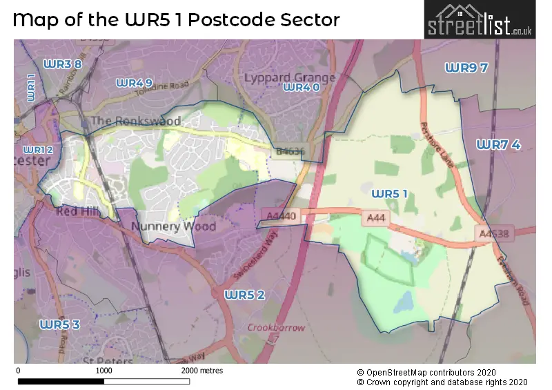
The WR5 1 Postcode shares a border with WR9 7 (DROITWICH, Wychbold, Copcut), WR7 4 (Inkberrow, Crowle, Upton Snodsbury), WR1 2 (WORCESTER), WR4 0 (WORCESTER, Lyppard Hanford, Long Meadow), WR4 9 (WORCESTER, Warndon) and WR5 2 (WORCESTER, Norton, Whittington).
The sector is within the post town of WORCESTER.
WR5 1 is a postcode sector within the WR5 postcode district which is within the WR Worcester postcode area.
The Royal Mail delivery office for the WR5 1 postal sector is the Worcester City Delivery Office and Worcester Apc.
The area of the WR5 1 postcode sector is 2.99 square miles which is 7.75 square kilometres or 1,915.79 square acres.
The WR5 1 postcode sector is crossed by the M5 motorway.
Waterways within the WR5 1 postcode sector include the Worcester & Birmingham Canal.

Map of the WR5 1 Postcode Sector
Explore the WR5 1 postcode sector by using our free interactive map.
| W | R | 5 | - | 1 | X | X |
| W | R | 5 | Space | 1 | Letter | Letter |
Official List of Streets
WORCESTER (117 Streets)
Whittington (14 Streets)
Spetchley (1 Streets)
Unofficial Streets or Alternative Spellings
Egdon
EVESHAM ROADHindlip
PERSHORE LANEWORCESTER
DON ROAD FOUNDRY STREET GEORGE STREET LARK HILL ROAD LONDON ROAD NUNNERY WAY PERRY WOOD WALK RONKSWOOD HILL SHERRIFF STREET VICTORIA PLACE WOODSIDE ROAD BRENT WOOD CLOSE DOLTONS YARD FOUNDRY ROAD HORNHILL ROAD LITTLE PARK STREET OAKMOUNT DRIVE ROSE AVENUE ROSE BANK SWINESHERD WAY WOODGREEN DRIVE WYE CLOSESchools and Places of Education Within the WR5 1 Postcode Sector
Abigail's Place
Other independent special school
St. Ann's School, , , WR5 1RS
Head: Mrs Nina Stone
Ofsted Rating: Good
Inspection: 2022-07-14 (679 days ago)
Website: Visit Abigail's Place Website
Phone: 01905622322
Number of Pupils: 9
Fort Royal
Community special school
Wyld's Lane, Worcester, Worcestershire, WR5 1DR
Head: Mr Edward Francis
Ofsted Rating: Good
Inspection: 2021-09-29 (967 days ago)
Website: Visit Fort Royal Website
Phone: 01905355525
Number of Pupils: 242
Newbridge School
Academy alternative provision sponsor led
Midland Road, Worcester, Worcestershire, WR5 1DS
Head: Headteacher Ian Enwright
Ofsted Rating: Good
Inspection: 2023-10-19 (217 days ago)
Website: Visit Newbridge School Website
Phone: 01905763580
Number of Pupils: 38
Nunnery Wood Primary School
Academy converter
Prestwich Avenue, Worcester, Worcestershire, WR5 1QE
Head: Mrs Rachel Higgins
Ofsted Rating: Good
Inspection: 2022-10-19 (582 days ago)
Website: Visit Nunnery Wood Primary School Website
Phone: 01905354154
Number of Pupils: 405
Perry Wood Primary and Nursery School
Academy sponsor led
St Albans Close, Worcester, Worcestershire, WR5 1PP
Head: Mrs Suzanne Beston
Ofsted Rating: Good
Inspection: 2019-02-13 (1926 days ago)
Website: Visit Perry Wood Primary and Nursery School Website
Phone: 01905354800
Number of Pupils: 413
Stanley Road Primary School
Academy converter
Stanley Road, Worcester, Worcestershire, WR5 1BD
Head: Mrs Lorraine Adams
Ofsted Rating: Requires improvement
Inspection: 2023-06-21 (337 days ago)
Website: Visit Stanley Road Primary School Website
Phone: 01905355043
Number of Pupils: 322
House Prices in the WR5 1 Postcode Sector
| Type of Property | 2018 Average | 2018 Sales | 2017 Average | 2017 Sales | 2016 Average | 2016 Sales | 2015 Average | 2015 Sales |
|---|---|---|---|---|---|---|---|---|
| Detached | £354,142 | 26 | £295,203 | 18 | £284,667 | 12 | £287,875 | 44 |
| Semi-Detached | £190,046 | 67 | £185,036 | 54 | £182,405 | 57 | £176,101 | 74 |
| Terraced | £202,544 | 45 | £161,999 | 38 | £164,333 | 43 | £151,963 | 55 |
| Flats | £130,167 | 15 | £107,000 | 10 | £116,615 | 13 | £107,923 | 13 |
Important Postcodes WR5 1 in the Postcode Sector
WR5 1AQ is the postcode for Duckworth Engineering Centre, Units A, B & C, Central Park, Great Western Avenue, Units A B And C, Central Park, Great Western Avenue, and Duckworth Engineering Centre, Units A, B & C, Central Park
WR5 1BD is the postcode for STANLEY ROAD PRIMARY SCHOOL, STANLEY ROAD, WORCESTER, and Stanley Road Primary School, Stanley Road
WR5 1DD is the postcode for Worcestershire Acute Hospitals NHS Trust, Worcestershire Royal Hospital, ACONBURY, Worcestershire Acute Hospitals NHS Trust, Worcestershire Royal Hospital, Worcestershire Acute Hospitals NHS Trust, Worcestershire Royal Hospital, Charles Hastings Way, CHEC, Worcestershire Acute Hospitals NHS Trust, Worcestershire Royal Hospital, ACONBURY (EAST & WEST BLOCKS), Worcestershire Acute Hospitals NHS Trust, Worcestershire Royal Hospital, and RADIOTHERAPY, Worcestershire Acute Hospitals NHS Trust, Worcestershire Royal Hospital
WR5 1DR is the postcode for Fort Royal Community Primary School, Wylds Lane
WR5 1DS is the postcode for Newbridge Secondary School, Midland Road, Newbridge School, Midland Road, Newbridge School, Midland Road, Worcester, and The Perryfields Centre, Midland Road
WR5 1HG is the postcode for Turnpike House Medical Centre, 37 Newtown Road
WR5 1JG is the postcode for ACONBURY NORTH, Worcester Royal Hospital, Newtown Road, Worcestershire Mental Health Partnership NHS Trust, Elgar Unit (oasu) Newtown (wri), NEWTOWN, Worcester Royal Hospital, Newtown Road, ELGAR UNIT, Worcester Royal Hospital, Newtown Road, and Worcestershire Mental Health Partnership NHS Trust, Acute Mental Health Wards (wri)
WR5 1JR is the postcode for Hereford & Worcester Fire & Rescue Service, Fire Station Unit, 2 Charles Hastings Way, Kings Court Business Park
WR5 1PP is the postcode for Perry Wood Primary & Nursery School, St Alban's Close
WR5 1QE is the postcode for Nunnery Wood Primary School, Prestwich Avenue
| The WR5 1 Sector is within these Local Authorities |
|
|---|---|
| The WR5 1 Sector is within these Counties |
|
| The WR5 1 Sector is within these Water Company Areas |
|