The WR5 3 postcode sector is within the county of Worcestershire.
Did you know? According to the 2021 Census, the WR5 3 postcode sector is home to a bustling 13,831 residents!
Given that each sector allows for 400 unique postcode combinations. Letters C, I, K, M, O and V are not allowed in the last two letters of a postcode. With 320 postcodes already in use, this leaves 80 units available.
The largest settlement in the WR5 3 postal code is WORCESTER followed by Kempsey, and Broomhall.
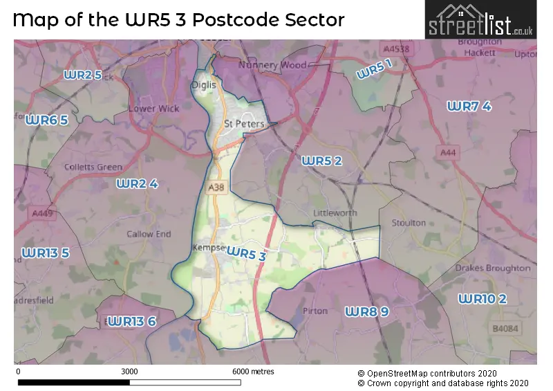
The WR5 3 Postcode shares a border with WR7 4 (Inkberrow, Crowle, Upton Snodsbury), WR8 9 (Severn Stoke, Defford, Earls Croome), WR1 2 (WORCESTER), WR2 4 (WORCESTER, Powick, Callow End) and WR5 2 (WORCESTER, Norton, Whittington).
The sector is within the post town of WORCESTER.
WR5 3 is a postcode sector within the WR5 postcode district which is within the WR Worcester postcode area.
The Royal Mail delivery office for the WR5 3 postal sector is the Worcester City Delivery Office and Worcester Apc.
The area of the WR5 3 postcode sector is 6.20 square miles which is 16.06 square kilometres or 3,968.49 square acres.
The WR5 3 postcode sector is crossed by the M5 motorway.
Waterways within the WR5 3 postcode sector include the River Severn, Worcester & Birmingham Canal, Diglis Basin.

Map of the WR5 3 Postcode Sector
Explore the WR5 3 postcode sector by using our free interactive map.
| W | R | 5 | - | 3 | X | X |
| W | R | 5 | Space | 3 | Letter | Letter |
Official List of Streets
Kempsey (73 Streets)
WORCESTER (144 Streets)
Unofficial Streets or Alternative Spellings
WORCESTER
BATTENHALL ROAD BOLSTON ROAD MILL STREET RED HILL LANE THE HILL AVENUE TIMBERDINE AVENUE TIMBERDINE CLOSEPirton
WORCESTER ROAD ACLE WALK ALDERSEY PEDWAY ALTON WALK ARRAN PEDWAY BARNES PLACE BATSFORD PEDWAY BICTON COURT BITTERN PEDWAY BLAKENEY WALK BLOSSOM FIELD DRIVE BLOSSOMFIELD WAY BLUEBELL PEDWAY BRADLEY COURT BROOMHALL BROOMHALL WAY BULLFINCH WALK CELANDINE PEDWAY COLTISHALL WALK COMMANDERY ROAD CRANESBILL PEDWAY CROOKBARROW WAY DEER PEDWAY DEREHAM PEDWAY DERRINGTON MEWS DIGLIS BRIDGE DIGLIS PARADE DRAYCOTT LANE DUCK BROOK PEDWAY EAGLE PEDWAY EDEN COURT FALCON WALK FOX LANE FOX WALK FOXGLOVE PEDWAY GREEN HILL BATH ROAD GREENWAY DRIVE HILL SIDE HYACINTH WALK HYDRANGEA PEDWAY JASMINE WALK KETCH ROUNDABOUT KITE PEDWAY LARKSPUR PEDWAY LEVEN PEDWAY MALVERN PEDWAY MOLE PEDWAY NORTON ROUNDABOUT ORCHID WALK OSPRAY WALK OTTER WALK PARTRIDGE WALK PEAR TREE DRIVE PETUNIA PEDWAY POLLARD COURT PRIMROSE DRIVE RAVEN WALK RAVENSHILL PEDWAY ROACH WALK ROSE PEDWAY SAINT MARKS CLOSE SAINT MARKS COURT SAINT MARYS CLOSE SAINT PETERS HILL SALTWELLS PEDWAY SHERINGHAM WALK SHREW PEDWAY SPARROW WALK SQUIRREL WALK ST DUNSTANS CLOSE STALHAM PEDWAY STARLING PEDWAY STROMA WALK SWAFFHAM PEDWAY SWALLOW WALK TEMESIDE WAY THE FREELANDS THE GLADE THISTLE PEDWAY TIREE WALK TREFOIL PEDWAY WOODBRIDGE PEDWAY WORCESTER ROADBroomhall
BROOMHALL GREEN BROOMHALL LANE NORTON ROAD TAYLORS LANESchools and Places of Education Within the WR5 3 Postcode Sector
Kempsey Primary School
Academy converter
Ellsdon, Worcester, Worcestershire, WR5 3NT
Head: Mrs Bryony Baynes
Ofsted Rating: Good
Inspection: 2020-01-29 (1588 days ago)
Website: Visit Kempsey Primary School Website
Phone: 01905820262
Number of Pupils: 361
House Prices in the WR5 3 Postcode Sector
| Type of Property | 2018 Average | 2018 Sales | 2017 Average | 2017 Sales | 2016 Average | 2016 Sales | 2015 Average | 2015 Sales |
|---|---|---|---|---|---|---|---|---|
| Detached | £345,900 | 137 | £348,476 | 150 | £290,352 | 137 | £307,299 | 87 |
| Semi-Detached | £217,592 | 91 | £208,329 | 91 | £196,593 | 80 | £197,954 | 55 |
| Terraced | £182,200 | 57 | £186,105 | 70 | £185,345 | 83 | £164,849 | 73 |
| Flats | £182,887 | 39 | £162,398 | 68 | £168,643 | 69 | £173,647 | 85 |
Important Postcodes WR5 3 in the Postcode Sector
WR5 3DY is the postcode for Cherry Orchard Vocational Training Centre, Orchard Street
WR5 3NT is the postcode for Kempsey Primary School, Ellsdon, NEW BUILDING, KEMPSEY PRIMARY SCHOOL, ELLSDON, and MAIN BUILDING, KEMPSEY PRIMARY SCHOOL, ELLSDON
| The WR5 3 Sector is within these Local Authorities |
|
|---|---|
| The WR5 3 Sector is within these Counties |
|
| The WR5 3 Sector is within these Water Company Areas |
|